
Established 1865 Elevation 333 m Postal code 5374 | Postcode(s) 5374 BuchananBagot Well Hansborough Founded 1865 Federal division Division of Wakefield | |
 | ||
Location 100 km (62 mi) NE of Adelaide18 km (11 mi) NE of Kapunda9 km (6 mi) SW of Eudunda LGA(s) | ||
Hansborough is a locality along the former Morgan railway line adjacent to the Thiele Highway, in South Australia's Mid North region. It is situated 9 kilometres south-west of Eudunda and 18 kilometres north-east of Kapunda. The Light River runs through the locality.
Map of Hansborough SA 5374, Australia
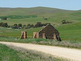
The town was originally surveyed in July 1865 and is named after early pastoralist and overlander Frederick Hansborough Dutton (1812-1890), who founded Anlaby Station, near Kapunda. Today it is virtually a ghost town, with a number of ruins at the site.
The Hundred of Neales School, later Freshwater Creek School, opened in 1927 in a former manager's residence on the Kingscourt property and closed in 1940.
References
Hansborough, South Australia Wikipedia(Text) CC BY-SA