
- elevation 1,500 m (4,921 ft) Basin area 277,100 km² Discharge 2,434 m³/s Country Canada | - elevation 120 m (394 ft) Length 1,115 km Basin area 277,100 km² | |
 | ||
- left Frances River (Yukon), Hyland River, Coal River (Canada), Smith River (British Columbia), Graying River, Scatter River, Beaver River (Laird River), South Nahanni River - right Meister River, Rancheria River (Yukon), Dease River, Kechika River, Rabbit River, Vents River, Trout River (British Columbia), Toad River, Fort Nelson River - average 2,434 m/s (85,956 cu ft/s) | ||
Drivelapse alaska highway liard river hotsprings provincial park to fireside bc
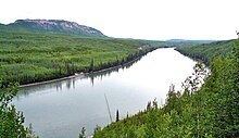
The Liard River flows through Yukon, British Columbia and the Northwest Territories, Canada. Rising in the Saint Cyr Range of the Pelly Mountains in southeastern Yukon, it flows 1,115 kilometres (693 mi) southeast through British Columbia, marking the northern end of the Rocky Mountains and then curving northeast back into the Yukon and Northwest Territories, draining into the Mackenzie River at Fort Simpson, Northwest Territories. The river drains approximately 277,100 square kilometres (107,000 sq mi) of boreal forest and muskeg.
Contents
- Drivelapse alaska highway liard river hotsprings provincial park to fireside bc
- Map of Liard River Canada
- Geography
- History
- Features
- Yukon
- British Columbia
- Northwest Territories
- Tributaries
- Communities
- References
Map of Liard River, Canada
Geography
The river habitats are a subsection of the Lower Mackenzie Freshwater Ecoregion. The area around the river in the Yukon Territory is called the Liard River Valley, and the Alaska Highway follows the river for part of its route. This surrounding area is also referred to as the Liard Plain, and is a physiographic section of the larger Yukon–Tanana Uplands province, which in turn is part of the larger Intermontane Plateaus physiographic division.
The Liard River is a crossing area for Nahanni wood bison.
History
The origin of the river's name is obscure, but is derived from the French word for "Eastern Cottonwood" (a kind of poplar) which grow in abundance along sections of the river. Among the early fur traders, the Liard above the Fort Nelson River was referred to as the "West Branch," while the Fort Nelson River was the "East Branch."
The first European to traverse most of the river was John McLeod of the Hudson's Bay Company (HBC). Leaving Fort Simpson on June 28, 1831, McLeod and eight others ascended the river, reaching and naming the Dease River in just over six weeks. Four days later, they reached the Frances River, and mistakenly ascended it, thinking it was the Liard's main branch. Nine years later, another HBC employee, Robert Campbell, journeyed to the source of the Liard in the St. Cyr Range, renaming the river McLeod had ascended for Frances Ramsay Simpson, the wife of the Sir George Simpson, the HBC's governor who had authorised both expeditions.
Features
Yukon
The Liard River originates in south-eastern part of the Yukon, on the slopes of Mount Lewis, at 61.23654°N 131.62738°W / 61.23654; -131.62738, at an elevation of 1,500 meters (4,900 ft). It flows south and east, between the ranges of Pelly Mountains, then south through the Yukon Plateau, where it receives the waters of Prospect Creek. It turns east after it receives the waters of the Caribou Creek from Caribou Lakes, then the Swede and Junkers Creek. It then follows the southern rim of the St. Cyr Range of the Pelly Mountains, where the Ings River flows into it. It follows the southern edge of the Simpson Range, receiving the waters of the Old Gold Creek, Rainbow Creek, Dome Creek, Quartz Creek and Scurvy Creek. The Liard River continues south-east, north of the Cassiar Mountains, from where it receives the Sayyea Creek and Cabin Creek while the Eckman Creek,Black River and Hasselberg Creek flow in from the north. It continues in a south-east direction, receiving the Sambo Creek, False Pass Creek, Meister River, Frances River, Rancheria River, Tom Creek, Watson Creek and Albert Creek before it flows through Upper Liard, west of Watson Lake, where it is crossed by the Alaska Highway. It receives the waters of Cormier Creek, then flows through the Liard Canyon and into British Columbia.
British Columbia
It flows south-east and east along the Alaska Highway, receiving the waters of Dease River, Kloye Creek, Trepanier Creek and Black Angus Creek. It continues east through the Dease Forest, where it receives the waters of the Hyland River south of Hyland River Provincial Park, then receives the Malcolm Creek, Tatisno Creek and Nustlo Creek. It flows along the Yukon border, where the Alaska Highway once again follows the Liard and receives the Cosh Creek, Contact Creek, Scoby Creek and Sandin Brook, then turns south around Mount Sandin, receiving water from Tsia Creek, Tsinitla Creek, Tatzille Creek and Leguil Creek. It turns eastwards along the northern margin of the Liard Plateau, where it receives the Kechika River near Skooks Landing, Niloil Creek from Niloil Lake and Coal River by Coal River. It continues east and south-east, south of Mount Reid, still followed by the Alaska Highway, receiving the waters of Geddes Creek, Grant Creek, Smith River, Lapie Creek, Teeter Creek, Mould Creek and Hoole Creek.
It enters the Liard River Hot Springs Provincial Park, where the Trout River empties into the Liard. Alaska Highway runs south along the Trout River, while the Liard flows east through the Liard River Corridor Provincial Park and Protected Area, south of the Sentinel Range of the Muskwa Ranges, receiving the waters of Deer River and Canyon Creek in the Grand Canyon of the Liard. It continues south-east between the Barricade Range and Mount Rothenberg of the Sentinel Range, where the Moule Creek and Sulphur Creek flow in the Liard. It flows east, out of the Northern Rockies and through the foothills, where it receives waters from the Brimstone Creek, Crusty Creek, Grayling River, Graybank Creek and Toad River. It turns north-west, receiving the waters from Garbutt Creek, Lepine Creek, Chimney Creek, Ruthie Creek, Scatter River and Beaver River. It then turns south-east, receives the waters from Catkin Creek, Dunedin River and Fort Nelson River. From here it turns north, receiving the waters of Zus Creek, Sandy Creek and La Biche River and crosses into the Northwest Territories, immediately east of the Yukon border.
Northwest Territories
The Liard River continues north, receiving the waters of Big Island Creek, Kotaneelee River and Petitot River. It turns around Mount Coty of the Franklin Mountains near Fort Liard Airfield, where it meets the Liard Highway. It receives the waters of the Muskeg River, Rabbit Creek and Flett Creek as it flows east of the Liard Range and Mount Flett. The Liard meanders east of the Sawmill Mountain and receives waters from the Beaver Water Creek, Netla River and Bay Creek. After receiving the waters of South Nahanni River south of Nahanni Butte and east of the Nahanni National Park Reserve, the Liard turns east and north-east, receiving waters from Grainger River, Blackstone River, Dehdjida Creek, Matou River, Birch River and Poplar River. It then turns north, being followed by the Mackenzie Highway, and receives the Manners Creek before it empties into the Mackenzie River, immediately upstream of Fort Simpson, at Clay Point, at an elevation of 120 meters (390 ft). The Truesdell Island and Franklin-Clarke Island are formed at the river mouth.
Tributaries
From headwater to mouth, the tributaries of the Liard are:
Communities
From mouth to headwater, communities along the river include: