
Area 6.11 km² | Local time Sunday 5:14 AM | |
 | ||
Weather -3°C, Wind W at 5 km/h, 93% Humidity | ||
Alaska tour watson lake yukon terr stop 4
Watson Lake is a town in Yukon, Canada located at mile 635 on the Alaska Highway close to the British Columbia border. Population in 2013 was 1,474 (Yukon Bureau of Statistics). The town is named for Frank Watson, an American-born trapper and prospector, who settled in the area at the end of the nineteenth century.
Contents
Map of Watson Lake, Yukon, Canada
Watson Lake is near the Liard River, at the junction of the Robert Campbell Highway and the Alaska Highway. The Cassiar Highway's northern end is 22 kilometres (14 miles) west of Watson Lake. The town is also served by the Watson Lake Airport; the airport was formerly served by Canadian Pacific Airlines and other local and regional airlines, but now only provides corporate and charter services.
Watson Lake is the main centre of the small forestry industry in Yukon and has been a service centre for the mining industry, especially for the Cassiar asbestos mine in northern British Columbia and the Cantung tungsten mine on the Yukon-Northwest Territories border in the Mackenzie Mountains.
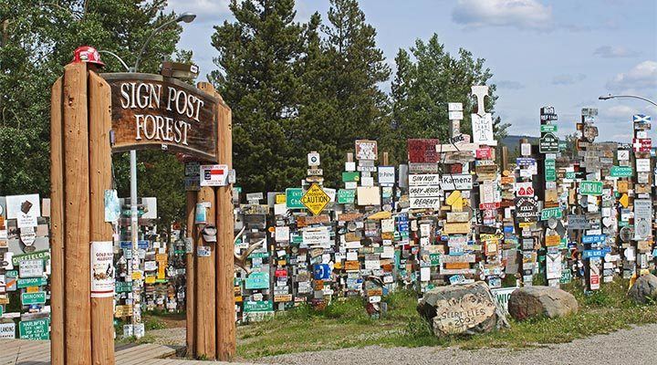
Tourist attractions in Watson Lake include the Northern Lights Centre and the much-imitated original Signpost Forest. The Signpost Forest was started in 1942 by a homesick U.S. Army G.I. working on the Alaska Highway, who put up a sign with the name of his home town and the distance. Others followed suit and the tradition continues to this day. As of August 2010 there are more than 76,000 signs of various types depicting locations across the world. The Signpost Forest is one of four roadside attractions featured on the first series of the Canadian Roadside Attractions Series issued by Canada Post on July 6, 2009.
Watson Lake and the neighbouring Upper Liard settlement are the home of the Liard River First Nation, a member of the Kaska Dena Council. The Two Mile area immediately north of the core of town is a concentrated area of First Nations residents, while the town extends five miles (8 km) out to the turn-off of Airport Road. (Originally, Airport Road extended directly to the Alaska Highway, but most of it is now part of the Campbell highway.)
Climate
Like most of Yukon, Watson Lake has a subarctic climate. Watson Lake experiences annual temperature average daily highs of 21 °C (69.8 °F) in July and average daily lows of −29 °C (−20.2 °F) in January. Record high temperature was 34 °C (93.2 °F) in May 1983 and the lowest was −59 °C (−74.2 °F) in January 1947. Watson Lake has more precipitation than other parts of Yukon with an average annual snowfall of 197 cm (77.6 inches) and 255 mm (10.04 inches) of rainfall, resulting in larger trees and a more viable forest industry.