
Isolation 0.50 mi (0.80 km) Elevation 4,033 m | Easiest route Scramble Prominence 118 m | |
 | ||
Topo map USGS 7.5' topographic mapLa Plata, Colorado Similar Hesperus Mountain, Sharkstooth Peak, Dolores Peak, Turret Peak, South River Peak | ||
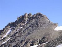
Lavender Peak is a high mountain summit in the La Plata Mountains range of the Rocky Mountains of North America. The 13,233-foot (4,033 m) thirteener is located in San Juan National Forest, 13.5 miles (21.7 km) northeast by east (bearing 61°) of the Town of Mancos in Montezuma County, Colorado, United States. The peak lies 0.53 miles (0.85 km) east-southeast of the higher and more well-known Hesperus Mountain. Lavender Peak was named in honor of Dwight Garrigues Lavender (1911-1934), the author of a 1932 climbing guide to the San Juan Mountains.
Contents
Map of Lavender Peak, Colorado 81326, USA
Historical namesEdit
References
Lavender Peak (Colorado) Wikipedia(Text) CC BY-SA