
Isolation 1.12 mi (1.80 km) Prominence 222 m Parent range San Miguel Mountains | Elevation 4,053 m Parent peak Middle Peak | |
 | ||
Topo map USGS 7.5' topographic mapDolores Peak, Colorado Similar Antora Peak, South River Peak, West Buffalo Peak, Sultan Mountain, Jacque Peak | ||
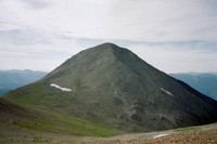
Dolores Peak is a high mountain summit in the San Miguel Mountains range of the Rocky Mountains of North America. The 13,296-foot (4,053 m) thirteener is located in the Lizard Head Wilderness, 16.7 miles (26.9 km) west-southwest (bearing 246°) of the Town of Telluride, Colorado, United States, on the drainage divide separating San Juan National Forest and Dolores County from Uncompahgre National Forest and San Miguel County.
Contents
Map of Dolores Peak, Colorado 81323, USA
Topographic prominenceEdit
Dolores Peak may be higher than neighboring Middle Peak on the same drainage divide. If this is the case, Dolores Peak would be the more topographically prominent of the two summits.
Historical namesEdit
References
Dolores Peak Wikipedia(Text) CC BY-SA