
Country Language spoken Capital Bandar Lampung | University Lampung University Area 35,376 km2 | |
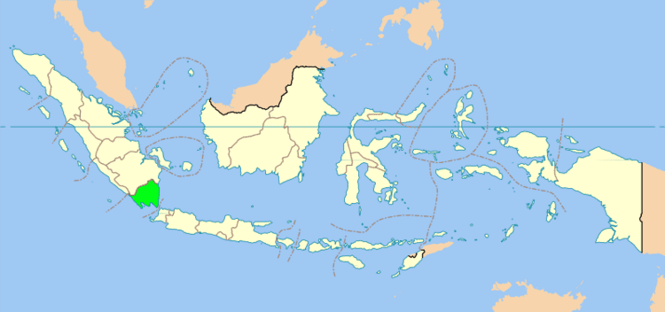 | ||
Map of Lampung
Lampung is a province of Indonesia. It is located on the southern tip of the island of Sumatra and borders the provinces of Bengkulu and South Sumatra which lie to the north. Lampung is the original home of the Lampung people, who speak their own language and have their own script. Its capital is Bandar Lampung.
Contents
- Map of Lampung
- Gopro tanjung putus trip lampung 2014
- History
- Geography
- Administrative divisions
- Agriculture
- Textiles
- Railroads
- Tourism
- Land
- Sea
- Air
- References
The province had a population of 7,596,115 at the 2010 census; the latest official estimate (as at January 2014) is 7,972,246. Three-quarters of the current population of Lampung is descended from migrants from Java, Madura, and Bali. These migrants came on their initiative, in search of more land than was available on the more densely populated islands, and as part of the national government's transmigration program, for which Lampung was one of the earliest and most significant transmigration destinations.
Lampung is commonly known for its geological instability in terms of earthquakes and volcanoes. On 10 May 2005, an earthquake measuring 6.4 on the Richter scale struck the province. The historical volcano blast of Krakatau which occurred in 1883, had disastrous consequences.
Gopro tanjung putus trip lampung 2014
History
In the 7th century, word spread in China about a region located in the far south (Namphang) about a kingdom called "Tolang Pohwang". "To" in Lampung language means "people" while "Lang Pohwang" is the region in what is now called Lampung . There is strong evidence that Lampung was part of the kingdom of Srivijaya, based in Jambi and controlled most parts of Southeast Asia including Lampung and prevail to the 11th century. Srivijaya came to Lampung as this area was once a source of gold and amber.
Relics found in Lampung shows that the region was under the influence of Srivijaya kingdom among others, with the discovery of Palas Pasemah inscriptions and the Batu Bedil inscriptions in the Tenggamus region which was dated from kingdom of Srivijaya. Other smaller kingdoms Tulang Bawang and Scale Brak also once stood at Lampung in about 7–8 century. The center of the Tulang Bawang kingdom was estimated around the Tulang Bawang river. The entry of the Banten Sultanate in Lampung at the 16th century marked the beginning of the spread of Islam in the region. Since the past, Lampung is known for pepper which at that time were much in demand. At that time the Dutch began pressing for control of the region.
The control of pepper production exercised by the Banten Sultanate has made Lampung as one of the greatest and most prosperous harbor in the archipelago. Similarly pepper plants that also attract foreign immigrants from Europe as trading companies of the Dutch East India Company. The trading company in the late 17th century to build a processing plant in Menggala. But the efforts finally Dutch managed to control 1856. The colonial government for the first time introduced the transmigration program to residents on the island of Java, which involved the migration of people from Java to Lampung. The transmigration program was quite well received and many residents of the island of Java origin who moved to the transmigration sites located in the eastern region of Lampung. The transmigration program is then increased again at the time of independence in the 1960s and 1970s. A native of the island of Java have brought along their culture device to Lampung like gamelan and wayang. People on the island of Bali then also came to Lampung to follow this transmigration program. The presence of migrants from other regions in Lampung has made this region as an area with diverse cultures (multi-cultural). Ethnic diversity that there would be a tourist attraction especially in various districts scattered potential of nature tourism, cultural tourism. The existence of art studios and culture as a preserver of art and culture.
The area was part of the Banten Sultanate until it was annexed by the Dutch in 1752 and then became known as Residentie Lampoengse Districten. It was part of the Dutch East Indies.
Geography
Lampung Province has an area of 35,376.50 km2 and lies between the latitudes of 105°45'-103°48 'E and 3°45'-6°45'S. The province borders the Sunda Strait to the southeast and the Java Sea to the east. There are islands located within Lampung Province, which are mostly located in the Bay of Lampung, among them Daro, Legundi, Tegal, Sebuku, Ketagian, Sebesi, Poahawang, Krakatoa, Putus, and Tabuan. There is also Pisang Island at the entrance to the regency of West Lampung.
Lampung natural state, along the coast in the west and the south, is an area of rolling hills connected to the Bukit Barisan range, which runs throughout Sumatra from north to south. In the center of the province is mostly lowland. Close to the coast in the east, along the shores of the Java Sea, further north, is the great waters.
The mountains are high enough at the top, among others:
The rivers that flow in Lampung by length and cathment area (c.a) are:
Great forests in the lowlands can be said to have been exhausted appropriated for development of agriculture, to the migrants who are constantly entering this area. Timber forest products are exported abroad. The forests are still there, where the land can be said not many open lies mostly in the west, in the area of Bukit Barisan Selatan.
Some cities in the provinces of Lampung height of 50 m over sea level is: Tandjungkarang (96 m), Kedaton (100 m), Metro (53), Gisting (480 m), State sakti (100 m), Pringsewu (50 m ), Pekalongan (50 m), Batang (65 m), Punggur (50 m), Padang queen (56 m), Wonosobo (50 m), Kedondong (80 m), Sidomulyo (75 m), Kasui (200 m), Sri Menanti (320 m) and Liwa (850 m).
Administrative divisions
Lampung Province is subdivided into twelve regencies (kabupaten) and two autonomous cities (kota), listed below with their areas and their populations at the 2010 Census and at the most recent (January 2014) estimates. A thirteenth regency – West Pesisir Regency – was formed on 25 October 2012 from part of West Lampung Regency, but no separate statistics are yet available.
* – The area and population for West Pesisir Regency are included in the figures for West Lampung Residency given above.
Agriculture
Some of the major crop in the country includes robusta coffee beans, cocoa beans, coconuts and cloves. This has resulted in a thriving agricultural sector with companies like Nestlé procuring coffee beans from the region. This agriculture has included illegal growing in Bukit Barisan Selatan National Park. In addition, nata de coco is also manufactured in the region by domestic companies like Wong Coco.
Textiles
Up until the 1920s, Lampung had a rich and varied weaving tradition. Lampung weaving used a supplementary weft technique which enabled coloured silk or cotton threads to be superimposed on a plainer cotton background. The most prominent Lampung textile was the Palepai, ownership of which was restricted to the Lampung aristocracy of the Kalianda Bay area. There were two types of smaller cloths, known as tatibin and tampan, which could be owned and used by all levels of Lampungese society. Weaving technologies were spread throughout Lampung. High quality weavings were produced by the Paminggir, Krui, Abung and Pesisir peoples. Production was particularly prolific among the people of the Kalianda Bay area in the south and the Krui aristocracy in the north.
Lampung textiles, Palepai, tatebin and tampan were called 'ship cloths' because ships are a common motif. The ship motif represents the transition from one realm of life to the next, for instances from boyhood to manhood or from being single to married and also represents the final transition to the afterlife.
Traditionally, Lampung textiles were used as part of religious ceremonies such as weddings and circumcisions. For instance, the Palepai cloths were used as long ceremonial wall-hangings behind the bridal party in aristocratic marriages. The smaller, more humble tampan cloths were exchanged between families at the time of weddings.
Production of many fine cloths blossomed in the late nineteenth century as Lampung grew rich on pepper production, but the devastating eruption of Krakatoa in 1883 destroyed many weaving villages in the Kalianda area. By the 1920s the increasing importance of Islam and the collapse of the pepper trade brought production to a halt Today Lampung textiles are highly prized by collectors.
Railroads
A 270 kilometer long rail track is planned from Tanjung Enim to Lampung. This rail track would be used for coal transportation to boost coal exports.
Tourism
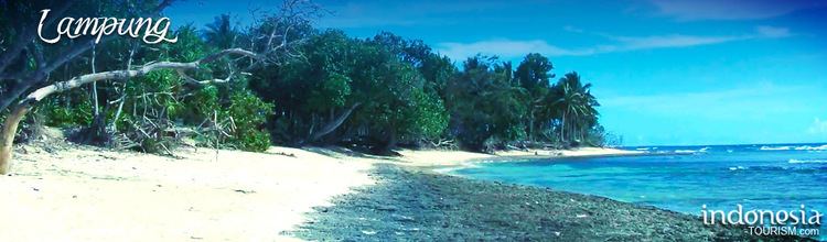
Tourism is not Lampung Province's main income, although the administration will boost tourism by organising a tourism event, Flamboyant Tanjung Setia, to draw tourists to Tanjung Setia Beach which has natural panoramic view and challenging waves for surfing. Another tourist attraction is the Way Kambas National Park, which is popular with local tourists. In 2010, there were 400,000 tourists who visited Lampung Province, including 10,000 foreign tourists who mainly came from Australia and New Zealand.
Way Kambas National Park is a national park and elephant sanctuary located in Lampung, precisely in the district of Labuhan Ratu, East Lampung, Indonesia. In addition to Way Kambas, another elephant school (Elephant Training Centre) can also be found in Minas, Riau. The number of Sumatran elephants (Elephas maximus sumatranus) living in the region is decreasing. Way Kambas National Park was established in 1985 is the first elephant school in Indonesia is expected to become a center for elephant conservation in taming, training, breeding and conservation. Until now, this PKG has trained about 300 elephants that have been deployed to other parts of the country.
In the recent years, the province has been largely popular for snorkeling and diving. Many domestic tourists as well as international ones from various diving communities had been visiting the different spots the province offers, such as Pantai Ringgung, Pulau Tegal, Pulau Pahawang, Pulau Kelagian, Pulau Balak, Pulau Mahitam, and Tanjung Putus.
Land
Up to now there is no highway in the province of Lampung, but the Bakauheni-Bandar Lampung-Terbanggi Besar tollway is currently being built which have begun the construction process since 30 April 2015, from Bakauheni in South Lampung to Terbanggi Besar in Central Lampung along the 139 kilometer which is planned fully operational in 2019.
The regional toll roads Bakauheni-Terbanggi Besar is expected to be completed in four years with funding from the private sector, government, private and government combined. As for the cost of this development, is predicted to reach Rp 53 trillion, including land acquisition and construction of approximately Rp30 trillion. Lampung has a bus terminal is Terminal Rajabasa which is one of the biggest and busiest in Sumatra and Lampung, besides there Talbot terminal that is in Bandar Lampung. Rajabasa airport s terminal at close range, intermediate, and far (AKAP) which has bus routes to cities in Sumatra and Java. Although Terminal Rajabasa has been renovated, but the eerie impression had not fully disappeared. Some passengers are still reluctant to enter the terminal area.
In addition to these two terminals, there are plenty of bus terminals located throughout the capital district in Lampung.
Sea
In this province there are the Port of Panjang which is an import-export harbor and also the Port Srengsem which served the traffic coal distribution from South Sumatra to Java. About 92 kilometers south of Bandar Lampung, there is Bakauheni , which is a port city in the province of Lampung, precisely at the southern tip of Sumatra. Located at the southern end of the Trans-Sumatran Highway, the Bakauheni port connects Sumatra with the Port of Merak in Java via sea transportation.
Air
Radin Inten II Airport is currently the only airport in the province. It serves flights to Jakarta, Medan, Bandung, Palembang, etc.