
Country United States County Belknap Time zone Eastern (UTC-5) Elevation 155 m Population 6,241 (2010) | State New Hampshire Incorporated 1768 Area code(s) 603 Zip code 03253 Local time Sunday 4:12 AM | |
 | ||
Weather -4°C, Wind NE at 6 km/h, 74% Humidity | ||
Welcome to meredith new hampshire
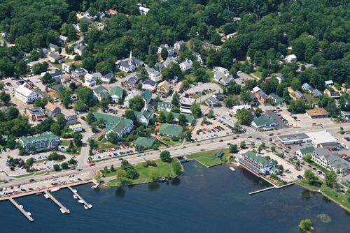
Meredith is a town in Belknap County, New Hampshire, United States. The population was 6,241 at the 2010 census. Meredith is situated beside Lake Winnipesaukee. It is home to the Stonedam Island Natural Area and the Winnipesaukee Scenic Railroad.
Contents
- Welcome to meredith new hampshire
- Map of Meredith NH USA
- History
- Geography
- Demographics
- Meredith village
- Government
- Education
- Notable people
- Sites of interest
- References
Map of Meredith, NH, USA
The primary village in town, where 1,718 people resided at the 2010 census, is defined as the Meredith census-designated place (CDP), and is located at the junction of U.S. Route 3 and New Hampshire Route 25 at the head of Meredith Bay on Lake Winnipesaukee.
Welcome to meredith new hampshire
History
Meredith was first known as Palmer's Town in honor of Samuel Palmer, a teacher of surveying and navigation who laid out much of the land surrounding Lake Winnipesaukee. In 1748, it was one of the first towns to have a charter granted by the Masonian Proprietors. Many grantees were from Salem, Massachusetts, so Palmer's Town was renamed New Salem. It was settled in 1766 by Jacob Eaton and Colonel Ebenezer Smith, then regranted in 1768 by Governor John Wentworth and named after Sir William Meredith, 3rd Baronet, a member of Parliament who opposed taxation on the colonies.
Farmers grew corn, wheat, rye and potatoes, but the area became noted for apple orchards. The outlet of Lake Waukewan provided water power sites, and by 1859 Meredith village had a sawmill, gristmill, shingle mill, blacksmith shop, harness-maker's shop and tannery. Situated at the outlet of Wickwas Lake, Meredith Center had a sawmill, gristmill and blacksmith shop. Connected by the Boston, Concord & Montreal Railroad in March 1849, the town became a summer resort. Passengers also arrived from the Alton Bay depot aboard steamboats, the most famous of which was the original SS Mount Washington, launched in 1872. Meredith remains a popular tourist destination.
Geography
According to the United States Census Bureau, the town has a total area of 54.2 square miles (140.4 km2), of which 39.9 square miles (103.4 km2) is land and 14.3 square miles (37.0 km2) or 26.37% is water. The highest point in Meredith is the summit of Leavitt Mountain, elevation 1,414 feet (431 m) above sea level, in the southwestern part of town.
Meredith village, formally defined by the U.S. Census Bureau as the Meredith census-designated place (CDP), has a total area of 1.9 sq mi (4.8 km2). 1.5 sq mi (3.8 km2) of it is land and 0.39 sq mi (1.0 km2) of it (20.08%) is water. Meredith village is the commercial hub of the town, and lies between the northern tip of Meredith Bay, one of several large arms of Lake Winnipesaukee and Lake Waukewan. A second village, Meredith Center, is located near the shores of Lake Wickwas closer the geographic center of the town. Meredith Center has much less commercial development than Meredith Village, being located near several protected state forests and wildlife areas.
The town is crossed by U.S. Route 3, New Hampshire Route 25, New Hampshire Route 104, and New Hampshire Route 106. It is bordered by the towns of Sanbornton to the southwest, New Hampton to the west, Center Harbor to the north, Moultonborough to the northeast across Lake Winnipesaukee, Gilford to the southeast, and Laconia to the south.
Like many other towns of the Lakes Region, Meredith is dominated by several large bodies of water. About half of the town's southeastern boundary with its neighbor Laconia is occupied by Winnisquam Lake, while the northern half of town lies within a peninsula, Meredith Neck, that separates Meredith Bay from the main body of Lake Winnipesaukee, giving Meredith an extensive coastline. Bear Island, the second largest on Winnipesaukee, and Stonedam Island, along with dozens of smaller islands are also part of the town. Several smaller lakes lie between Winnipesaukee and Winnisquam, including Wickwas Lake and Pemigewasset Lake. Lake Waukewan forms the western edge of the Meredith Village CDP and extends into neighboring New Hampton.
Demographics
As of the census of 2000, there were 5,943 people, 2,447 households, and 1,698 families residing in the town. The population density was 147.9 persons per square mile (57.1/km²). There were 4,191 housing units at an average density of 104.3 per square mile (40.3/km²). The racial makeup of the town was 97.91% White, 0.17% African American, 0.17% Native American, 0.57% Asian, 0.07% Pacific Islander, 0.22% from other races, and 0.89% from two or more races. 0.50% of the population were Hispanic or Latino of any race.
There were 2,447 households out of which 29.0% had children under the age of 18 living with them, 55.3% were married couples living together, 9.7% have a woman whose husband does not live with her, and 30.6% were non-families. 25.1% of all households were made up of individuals and 10.8% had someone living alone who was 65 years of age or older. The average household size was 2.38 and the average family size was 2.80.
In the town, the population was spread out with 22.5% under the age of 18, 5.6% from 18 to 24, 26.2% from 25 to 44, 28.9% from 45 to 64, and 16.8% who were 65 years of age or older. The median age was 42 years. For every 100 females there were 97.8 males. For every 100 females age 18 and over, there were 96.9 males.
The median income for a household in the town was $42,758, and the median income for a family was $54,764. Males had a median income of $35,766 versus $26,772 for females. The per capita income for the town was $24,867. 6.6% of the population and 4.2% of families were below the poverty line. Out of the total people living in poverty, 9.0% are under the age of 18 and 9.9% are 65 or older.
Meredith village
As of the census of 2000, there were 1,739 people, 710 households, and 445 families residing in Meredith village, a census-designated place (CDP). The population density was 1,148.0 people per square mile (444.7/km²). There were 832 housing units at an average density of 212.7 persons/km² (549.3 persons/sq mi). The racial makeup of the town was 97.12% White, 0.40% African American, 0.46% Native American, 0.58% Asian, 0.17% from other races, and 1.27% from two or more races. 0.52% of the population were Hispanic or Latino of any race.
There were 710 households out of which 31.3% had children under the age of 18 living with them, 43.1% were married couples living together, 14.9% have a woman whose husband does not live with her, and 37.2% were non-families. 30.3% of all households were made up of individuals and 11.7% had someone living alone who was 65 years of age or older. The average household size was 2.31 and the average family size was 2.83.
In the CDP, the population was spread out with 23.8% under the age of 18, 7.1% from 18 to 24, 29.3% from 25 to 44, 21.7% from 45 to 64, and 18.1% who were 65 years of age or older. The median age was 39 years. For every 100 females there were 89.6 males. For every 100 females age 18 and over, there were 86.6 males.
The median income for a household is $35,298, and the median income for a family was $42,292. Males had a median income of $32,679 versus $23,750 for females. The per capita income for the town was $18,903. 4.6% of the population and 4.3% of families were below the poverty line. Out of the total people living in poverty, 6.5% are under the age of 18 and 7.5% are 65 or older.
Government
In the New Hampshire Senate, Meredith is in the 2nd District, represented by Republican Bob Giuda. On the New Hampshire Executive Council, Meredith is in the 1st District, represented by Republican Joe Kenney. In the United States House of Representatives, Meredith is in New Hampshire's 1st congressional district, represented by Democrat Carol Shea-Porter.
Education
Meredith's Inter-Lakes High School is home to the Inter-Lakes Community Auditorium, which plays host to The Summer Theatre in Meredith Village (formerly the Lakes Region Summer Theater) every summer.