
Max. length 231 mi (372 km) Length 372 km | Area 1,497 km² Surface elevation 502 m | |
 | ||
Primary inflows Inflow source Missouri River, Cheyenne River, Moreau River, Grand River | ||
Midwest outdoors tv show 1565 lake oahe walleye in south dakota at new evarts resort
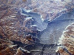
Lake Oahe (oh-WAH'-hee) is a large reservoir behind Oahe Dam on the Missouri River; it begins in central South Dakota and continues north into North Dakota in the United States. The lake has an area of 370,000 acres (1,500 km2) and a maximum depth of 205 ft (62 m). By volume, it is the fourth-largest reservoir in the US. Lake Oahe has a length of approximately 231 mi (372 km) and has a shoreline of 2,250 mi (3,620 km). 51 recreation areas are located along Lake Oahe, and 1.5 million people visit the reservoir every year. The lake is named for the 1874 Oahe Indian Mission.
Contents
- Midwest outdoors tv show 1565 lake oahe walleye in south dakota at new evarts resort
- Map of Lake Oahe United States
- Forced relocation of Native Americans during construction
- Dakota Access Pipeline
- References
Map of Lake Oahe, United States
Species of fish in the reservoir include walleye, northern pike, channel catfish, and smallmouth bass. Chinook Salmon, native to the Pacific Northwest, are artificially maintained in Lake Oahe and are a popular target for anglers. The lake also supports populations of the endangered pallid sturgeon.
Lake Oahe begins just north of Pierre, South Dakota and extends nearly as far north as Bismarck, North Dakota. Mobridge, South Dakota is located on the eastern shore of the central portion of the lake. A map centered on Mobridge 45°32′14″N 100°25′40″W probably gives the best view of the extent of the lake. Bridges over Lake Oahe include US Route 212 west of Gettysburg, South Dakota and US Route 12 at Mobridge. The former town of Forest City has been flooded beneath Lake Oahe, about 9 miles west of Gettysburg. Prehistoric archeological sites have been explored in the area, including Molstad Village near Mobridge. It dates to before the emergence of the Arikara, Hidatsa and Mandan as separate peoples, and has been designated as a National Historic Landmark.
Both the Cheyenne River Indian Reservation and the Standing Rock Indian Reservation occupy much of the western shoreline of Lake Oahe. Two possible burial sites of Sitting Bull, a Sioux leader, are located along Lake Oahe. One is near Fort Yates, North Dakota, while the other is near Mobridge.
Forced relocation of Native Americans during construction
In the 1960s, the Army Corps of Engineers and the Bureau of Reclamation built five large dams on the Missouri River, and implemented the Pick–Sloan Missouri Basin Program, forcing Native Americans to relocate from flooded areas. Over 200,000 acres on the Standing Rock Reservation and the Cheyenne River Reservation in South Dakota were flooded by the Oahe Dam alone. As of 2015, poverty remains a problem for the displaced populations in the Dakotas, who are still seeking compensation for the loss of the towns submerged under Lake Oahe, and the loss of their traditional ways of life.
Dakota Access Pipeline
Lake Oahe became a point of contention in protests to block the Dakota Access Pipeline. The construction project has been controversial for its environmental impacts, and several Native American tribes in the Dakotas and Iowa have opposed the project. These include several Sioux nations and the Meskwaki. In 2016 a group from the Standing Rock Indian Reservation brought a petition to the U.S. Army Corps of Engineers (USACE) and sued for an injunction to stop the project.
On December 4th, 2016 USACE denied the easement that "would allow the Dakota Access Pipeline to cross under Lake Oahe" and Jo-Ellen Darcy, the United States Assistant Secretary of the Army "said she based her decision on a need to explore alternate routes for the Dakota Access Pipeline crossing." Darcy said "that the consideration of alternative routes would be best accomplished through an Environmental Impact Statement with full public input and analysis."
President Trump soon thereafter issued "a memorandum and an executive order asking the corps to expedite its consideration of the company’s application for an easement to start construction."
The USACE subsequently "withdrew its call for the environmental study."
On 7 February 2017, the USACE approved an easement through Lake Oahe. On 9 February 2017, the Cheyenne River Sioux filed the first legal challenge to the easement, citing an 1851 treaty and interference with the religious practices of the tribe.