
NRHP Reference # 66000713 Area 4 ha | Designated NHL July 19, 1964 Added to NRHP 15 October 1966 | |
 | ||
Location | ||
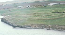
Molstad Village, designated by the Smithsonian trinomial 39DW234, is an archaeological site in Dewey County, South Dakota, United States, near the city of Mobridge. It was declared a National Historic Landmark in 1964. The site contains the remains of a small fortified Native America village, consisting of four circular earth lodges surrounded by a bastioned palisade. Evidence gathered at the site indicates it was occupied for a relatively brief period in the mid-1500s CE, and was assigned to the Chouteau aspect of Middle Missouri taxonomy, later known as the Extended Coalescent phase.
Molstad Village was named after Irene and Oscar Molstad, on whose ranch the village was found. The land belonged to Irene Molstad, a member of the federally recognized Cheyenne River Sioux Nation. She and her husband Oscar operated a cattle ranch, and allowed Smithsonian Institution researches to camp on their land while investing archaeological sites in the area in advance of the creation of Lake Oahe. The Molstad village site was excavated by this team in 1962 under the direction of J. Jake Hoffman. Finds at the site were important in enabling Hoffman to use pottery styles to establish a chronology of regional sites.