
County Hughes Incorporated 1883 Zip code 57501 | Founded 1880 Elevation 1,453 ft (442 m) Local time Friday 10:35 AM | |
 | ||
Weather 9°C, Wind E at 13 km/h, 65% Humidity Points of interest South Dakota Discovery, Fighting Stallions Memorial, South Dakota National | ||
Pierre south dakota
Pierre (/ˈpɪər/ PEER) (Lakota: čhúŋkaške; "fort") is the capital of the state of South Dakota and the county seat of Hughes County. The population was 13,646 at the 2010 census, making it the second least-populous state capital after Montpelier, Vermont.
Contents
- Pierre south dakota
- Map of Pierre SD 57501 USA
- Geography
- Climate
- 2010 census
- 2000 census
- Transportation
- Education
- FM radio
- Television
- Notable people
- In popular culture
- References
Map of Pierre, SD 57501, USA
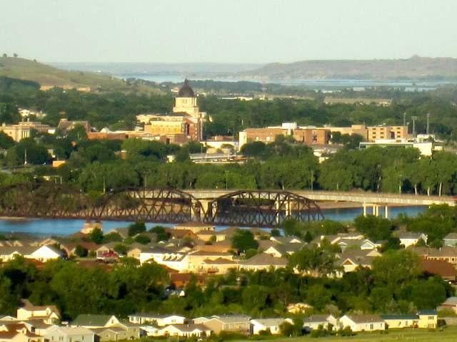
Founded in 1880 on the east bank of the Missouri River opposite Fort Pierre, Pierre has been the state capital since South Dakota gained statehood on November 2, 1889. It was chosen for its location in the geographic center of the state. Fort Pierre was named after Pierre Chouteau, Jr., a major American fur trader from St. Louis, Missouri who was of colonial French origin.
Pierre is the principal city of the Pierre Micropolitan Statistical Area, which includes all of Hughes and Stanley counties.
Geography
Pierre is located at 44°22′5″N 100°20′11″W (44.367966, −100.336378).
According to the United States Census Bureau, the city has a total area of 13.07 square miles (33.85 km2), of which, 13.06 square miles (33.83 km2) is land and 0.01 square miles (0.03 km2) is water.
Pierre lies on rough river bluffs above the east bank of the Missouri River, overlooking its expanse. It is a few miles away from Lake Oahe, one of the largest man-made lakes in the world. Developed for flood control and irrigation, the lake has become a very popular fishing destination.
Climate
Pierre has a relatively dry, four-season, humid continental climate (Köppen Dfa), with long, dry, cold winters, hot summers, and brief spring and autumnal transitions; as with much of the southern half of the state, it lies in USDA Plant Hardiness Zone 5. The monthly daily average temperature ranges from 19.9 °F (−6.7 °C) in January to 75.4 °F (24.1 °C), though the diurnal temperature variation is significantly greater during summer than in winter. Snow primarily falls in light amounts, with the snowiest months being February and March, while the average seasonal total is 32 inches (0.81 m). In addition, there are 20 nights per year with lows below 0 °F (−17.8 °C), and cold conditions are often intensified by the high winds of the Great Plains. Summers often see spikes in temperature, with 6.4 days of highs above 100 °F (37.8 °C) and 36−37 days with highs above 90 °F (32.2 °C).
The beginning of both May and October represent the last and first, respectively, freezing nights of the cooler season. Precipitation is much lighter in the winter months than it is in late spring and summer, and totals about 20 inches (508 mm) annually. Extremes have ranged from −35 °F (−37 °C) on February 9, 1994 to 117 °F (47 °C) on July 15, 2006.
2010 census
As of the census of 2010, there were 13,646 people, 5,778 households, and 3,463 families residing in the city. The population density was 1,044.9 inhabitants per square mile (403.4/km2). There were 6,159 housing units at an average density of 471.6 per square mile (182.1/km2). The racial makeup of the city was 85.1% White, 0.5% African American, 10.9% Native American, 0.6% Asian, 0.5% from other races, and 2.4% from two or more races. Hispanic or Latino of any race were 1.9% of the population.
There were 5,778 households of which 29.2% had children under the age of 18 living with them, 45.7% were married couples living together, 10.4% had a female householder with no husband present, 3.8% had a male householder with no wife present, and 40.1% were non-families. 35.0% of all households were made up of individuals and 11% had someone living alone who was 65 years of age or older. The average household size was 2.23 and the average family size was 2.87.
The median age in the city was 39.3 years. 22.9% of residents were under the age of 18; 7.5% were between the ages of 18 and 24; 26.7% were from 25 to 44; 28.9% were from 45 to 64; and 13.9% were 65 years of age or older. The gender makeup of the city was 47.8% male and 52.2% female.
2000 census
As of the census of 2000, there were 13,876 people, 5,567 households, and 3,574 families residing in the city. The population density was 1,065.8 people per square mile (411.5/km²). There were 5,949 housing units at an average density of 457.0 per square mile (176.4/km²). The racial makeup of the city was 88.91% White, 0.20% African American, 8.56% Native American, 0.46% Asian, 0.02% Pacific Islander, 0.29% from other races, and 1.56% from two or more races. Hispanics or Latinos of any race were 1.25% of the population.
There were 5,567 households, out of which 32.9% had children under the age of 18 living with them, 51.6% were married couples living together, 9.5% had a female householder with no husband present, and 35.8% were non-families. 31.5% of all households were made up of individuals, and 10.7% had someone living alone who was 65 years of age or older. The average household size was 2.35, and the average family size was 2.96.
In the city, the population was spread out, with 27.2% under the age of 18, 6.5% from 18 to 24, 28.6% from 25 to 44, 23.6% from 45 to 64, and 14.1% who were 65 years of age or older. The median age was 38 years. For every 100 females, there were 90.5 males. For every 100 females age 18 and over, there were 85.4 males.
As of 2000 the median income for a household in the city was $42,962, and the median income for a family was $52,144. Males had a median income of $32,969 versus $22,865 for females. The per capita income for the city was $20,462. About 5.5% of families and 7.8% of the population were below the poverty line, including 7.9% of those under age 18 and 9.2% of those age 65 or over.
Transportation
Great Lakes Airlines serves Pierre Regional Airport non-stop flights to Denver and Minneapolis–Saint Paul.
Public Transit is provided by River Cities Public Transit. With Local Shared Taxi program and regional bus service is provided.
Pierre is one of only four state capitals not served by an Interstate highway (along with Dover, Delaware, Jefferson City, Missouri, and Juneau, Alaska) and is the only state capital not served by any expressways. The nearest Interstate highway is Interstate 90, about 34 mi (55 km) south of Pierre via the four-lane U.S. Highway 83. I-390 is proposed to connect Pierre to I-90.
Education
The Pierre School District oversees three elementary schools, a middle school and a high school, T. F. Riggs High School. The only private school is St. Joseph, a Catholic elementary school administered by the local parish and the Diocese of Sioux Falls.
FM radio
- 104.5 FM||KCCR-FM||Capitol City Rock 104.5||Active Rock||Riverfront Broadcasting||Pierre||Blunt
Television
Pierre is part of the Sioux Falls television market; all of the city's commercial stations are satellites of Sioux Falls stations.
The Capital Journal is the local newspaper. OaheTV is the local Public/Education/Government cable channel serving Pierre, Fort Pierre on Midcontinent Communications Cable
Notable people
In popular culture
In 2015, in honor of the Monopoly game's 80th birthday, Hasbro held an online vote in order to determine which cities would make it into an updated version of the "Here and Now: The US Edition" of the game. The top "Boardwalk" spot went to an unexpected contender: Pierre. It got the highest number of votes, beating out cities like New York, Los Angeles, Chicago, and Boston. The picture, which accompanied the name of the city in the balloting, was of the well-known Mt. Rushmore even though the sculpture is in Keystone, SD, some 150 miles to the west of Pierre.
Pierre is home to many attractions including the Oahe Dam and the world's largest Menards, a regional home improvement store.