
Basin countries United States | ||
 | ||
Similar Calumet River, Big Marsh Park, Chicago Sanitary and Ship, Pullman National Monument, Grand Calumet River | ||
Lake Calumet is the largest body of water within the city of Chicago. Formerly a shallow, postglacial lake draining into Lake Michigan, it has been changed beyond recognition by industrial redevelopment and decay. Parts of the lake have been dredged, and other parts reshaped by landfill. Together with the rest of the city of Chicago, the remnant of the lake now drains into the Des Plaines River and the Mississippi River basin.
Contents
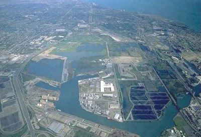
- Map of Lake Calumet Chicago IL 60633 USA
- HistoryEdit
- TodayEdit
- EcologyEdit
- Superfund statusEdit
- Maps and imagesEdit
- References
Map of Lake Calumet, Chicago, IL 60633, USA
Calumet is a Norman word used since the 17th century by French colonists in Canada for the ceremonial pipes they saw used by First Nations peoples.
HistoryEdit
Until the 1800s, Lake Calumet was near the center of an extensive wetland area near the southern tip of Lake Michigan. Like other wetland areas, the Lake Calumet area and its rivers were a center of Native American life and settlement. The Field Museum maintains databases of archeological data on these settlements.
In 1861, the Lake Calumet region was mapped into Hyde Park Township, south of what was then the town of Chicago. In the 1880s, because the lake's Calumet River created shipping opportunities to connect into Lake Michigan, the swampy zone was rapidly filled and developed by industry. Hyde Park Township developed rapidly and was annexed into Chicago in 1889. The area remains heavily industrialized today.
The Chicago neighborhood of Pullman was developed as a company town with residences and services offered for rent to the workers in railroad passenger car factories. The complex, now a National Monument, is sited on the lake's west shore. Steel mills began to line the Calumet River. The Illinois Central railroad was built nearby.
In the 1950s, part of the former lakebed was used as a right-of-way for a freeway, which was originally named in the lake's honor as the Calumet Expressway.
Another parcel of former wetland, south of the lake, was designated as what is now the Paxton Landfill, the final home for much of the household and industrial solid waste generated within the city of Chicago. Some of the landfill was steel mill slag and other industrial wastes. The revelation of hazardous chemicals in much of the fill material has created a push to have parts of the Lake Calumet area added to the national Superfund list for environmental cleanup.
In the early 1980s, the Lake Calumet area was proposed as a site for the later-cancelled 1992 Chicago World's Fair.
In 1996, the Calumet Expressway was renamed the Bishop Ford Freeway, honoring Chicago religious leader Bishop Louis Henry Ford.
TodayEdit
The remains of Lake Calumet lie east of the Bishop Ford Freeway (Interstate 94) on the far south side of Chicago, between 103rd and 130th streets. The lake is part of the underutilized Port of Chicago. A lakeside grain elevator can be seen from the freeway. South of the lake, the freeway passes the Paxton Landfill, including pipes that collect methane and other gases generated by the landfill.
The vestigial lake officially lies within Chicago's South Deering community area. Cleanup efforts in former landfills areas continue as of 2010; see Superfund status subsection below.
EcologyEdit
The wetlands surrounding Lake Calumet were noted as the only location where specimens of Thismia americana, an example of endemic wet prairie flora, were ever collected. Due to the profound physical changes that have taken place in the Lake Calumet catchment area, this plant is now believed to be extinct.
Although Lake Calumet has undergone extensive human alteration over the period from 1880 through 2010, parts of the basin remain a wetland. The basin has been designated an Important Bird Area of Illinois and is part of the flyway along Lake Michigan and the rivers.
Superfund statusEdit
On March 2, 2010, the EPA designated the Lake Calumet Cluster, a cluster of sites grouped around Lake Calumet, for the Superfund List. Several local areas within this cluster are extremely hazardous; excavation workers must use masks and self-contained supplies of air or oxygen.
Despite these challenges, planners hope to conduct remedial cleanups of less-severely contaminated sites to permit adaptive reuse. They will cap the more heavily contaminated sites within the cluster. Landfill gas could be collected and the methane filtered for use.