
 | ||
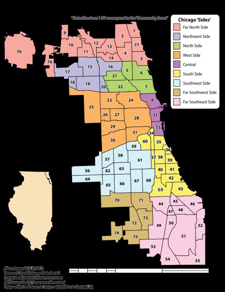
Community areas in Chicago refers to the work of the Social Science Research Committee at the University of Chicago, which divided the city of Chicago into 77 community areas which are officially recognized by the City of Chicago. These areas are well-defined and static. Census data are tied to the community areas, and they serve as the basis for a variety of urban planning initiatives on both the local and regional levels.
Contents
The Social Science Research Committee at University of Chicago defined seventy-five community areas during the late 1920s. At the time, these community areas corresponded roughly to neighborhoods or inter-related neighborhoods within the city. In the 1950s, with the city's annexations for O'Hare International Airport, a seventy-sixth community area was added. Other than the creation of the seventy-seventh community area in 1980 (by separating Edgewater from Uptown), boundaries have never been revised to reflect change but instead have been kept stable to allow comparisons of these areas over time.
Community areas are distinct from neighborhoods in Chicago. Community areas often encompass groups of neighborhoods. Although many community areas contain more than one neighborhood, they may also share the same name, or parts of the name, of some of their individual neighborhoods. Political wards of the Chicago City Council are also a distinct geographic concept but may be important in reading history or in modern contexts; they however are redistricted over-time and their boundaries change.
Central
The city center area covers a little more than 4 square miles (10 km2), lying roughly between Division Street (1200 North) on the north, Lake Michigan on the east, 26th Street (2600 South) on the south and Halsted (800 West) on the west. This area is city's commercial hub. The three branches of the Chicago River meet in this area.
The area known as the Loop is a section within downtown, surrounded by elevated tracks of the rapid transit network. Many of downtown's commercial, cultural, and financial institutions are located in the Loop. Today, the Loop is also used to identify the larger downtown area.
River North contains the Magnificent Mile, a concentration of high-end retail. The central area is home to Grant and Millennium Parks, skyscrapers, museums, and shopping; and is the site of the city's largest parades: the annual Christmas, Thanksgiving and Saint Patrick's Day parades. The Chicago Bears play in Soldier Field on the Near South Side.
North Side
The city's North Side district extends north of Central−Downtown Chicago, the West Side districts, and the Chicago River to the city's northern and northwestern borders. It is the most densely populated residential section of the city, and has a considerable middle and upper-class demographic. It contains sizable public parklands (such as the huge Lincoln Park) and miles of beaches along Lake Michigan to the city's northern limits. Residential highrises line the waterfront in the eastern North Side. The district includes Eastern European, Puerto Rican, and other ethnic enclaves. It is the home of the Chicago Cubs at Wrigley Field.
West Side
The West Side (extending west of downtown) is made up of neighborhoods such as Austin, Lawndale, Garfield Park, West Town, and Humboldt Park among others. Some neighborhoods, particularly Garfield Park and Lawndale, have had long-term socio-economic problems. Other West Side neighborhoods, especially those closer to downtown, have been undergoing gentrification. The United Center, the home of the Chicago Bulls and Blackhawks, and University of Illinois at Chicago are located on the Near West Side.
Major parks on the West Side include Douglas, Garfield, and Humboldt Park. Garfield Park Conservatory houses one of the largest collections of tropical plants of any U.S. city. Attractions on the West Side include the Puerto Rican Day festival, the National Museum of Mexican Art in Pilsen, and Oprah Winfrey's Harpo Studios near the city center.
South Side
The South Side is the largest section of the city, encompassing roughly 60% of the city's land area, and much was annexed in the late 19th century. The section along the lake is marked with public parkland and beaches. The South Side has a higher ratio of single-family homes and also contains most of the city's remaining industry. Historically it was the location of the stockyards, and its industries attracted hundreds of thousands of European immigrants and African-American migrants in the late 19th and early 20th centuries. More recent immigrants have come from Mexico and Latin America. The Chicago White Sox have played at three different stadiums in the area since 1900—first South Side Park (1900–1910), then the original Comiskey Park (1910–1990), and finally their current home, originally named Comiskey Park, then named U.S. Cellular Field in 2003, but now known as Guaranteed Rate Field since 2016 (1991–present).
Along with being the largest section of the city in terms of geography, the South Side is also home to one of the city's largest parades: the annual Bud Billiken Day parade. Held during the second weekend of August, it celebrates children returning to school.
The South Side has two of Chicago's largest public parks. Jackson Park, which hosted the World's Columbian Exposition in 1893, is the site of the Museum of Science and Industry. The park stretches along the waterfront, situated between the neighborhoods of Hyde Park and South Shore. Washington Park sits slightly west of Jackson Park and the two are connected by a strip of parkland known as Midway Plaisance, which runs parallel to the University of Chicago.
Parishes
Another method of neighborhood nomenclature in heavily Catholic neighborhoods of Chicago has been to refer to communities in terms of parishes. For example, one might say, "I live in St. Gertrude's, but he's from Saint Ita's." Some of these designations have come into common parlance as developers have used them to market new gentrifying areas such as "St. Ben's", a neighborhood found on the Chicago Realtor Association's official Chicago Neighborhood map. Chicago's Polish Patches are also named after the historically Polish church located in the vicinity.
Wards
Since 1923, the city of Chicago has been divided into 50 City Council Aldermanic wards. Each of the 50 areas is represented on the City council by one Alderman. In many social, political and economic contexts, it is reasonable to describe one's residence in Chicago by who one's alderman is or what ward one lives in. However, using wards as the basis for comparing areas of the city over time has limited utility, as the wards must be redistricted every ten years related to population. The current ward boundaries were mapped in 2011.