
Country United States Area 1,588 km² | Established April 1, 1832 Population 111,281 (2013) Unemployment rate 5.9% (Apr 2015) | |
 | ||
Named for "The Door" or "The Port" (fr.) Points of interest Blue Chip Casino - Hotel and, Old Michigan City Light, Washington Park Zoo, John H Barker Mansion, Hesston Steam Museum | ||
LaPorte County is a county located in the U.S. state of Indiana. As of 2010, the population was 111,467. The county seat is the city of La Porte, and the largest city is Michigan City.
Contents
- Map of LaPorte County IN USA
- History
- Geography
- Adjacent counties
- National protected area
- Railroads
- Municipalities
- Townships
- Public libraries
- Hospitals
- Climate and weather
- Education
- Government
- Demographics
- References
Map of LaPorte County, IN, USA
This county is part of the Northwest Indiana and Michiana regions of the Chicago metropolitan area.
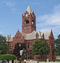
The LaPorte County Courthouse is located in the county seat of La Porte and is listed on the National Register of Historic Places.
History
LaPorte County was formed in 1832. La porte means "the door" or "the port" in French. French travelers or explorers so named the area after discovering a natural opening in the dense forests that used to exist in this region, providing a gateway to lands further west.
Before white settlement, all of the land that forms modern-day LaPorte County, and adjacent Starke County to the south belonged to the Potawatomi Indian nation. These Indians were forcibly removed to Kansas by the United States government in 1838, and many died on what survivors called the Trail of Death.
LaPorte County's initial White American settlers were Yankee immigrants, that is to say they were from New England or were from upstate New York and had parents who were from New England, and were descended from the English Puritans who settled New England in the colonial era. They were part of a wave of New England settlers moving west into what was then the Northwest Territory after the completion of the Erie Canal. The original White settlers in LaPorte County specifically hailed from the Massachusetts towns of Granville, Boston, Bridgewater, West Bridgewater, Andover, Nantucket Island and Hampshire County; the Connecticut towns of Colchester, Wethersfield, Granby and New Haven; the New Hampshire towns of Bradford, Amherst and Goffstown; the Vermont villages of Dorset, Albany and Fairfax; many also came from Orange County, Vermont, Caledonia County, Vermont and Penobscot County, Maine. They were mainly members of the Congregational Church, but as a result of the Second Great Awakening many became Baptists and many also converted to Pentecostalism and Methodism. When they arrived in what is now LaPorte County, there was nothing but virgin forest and wild prairie, the New England settlers cleared roads, built farms, constructed churches, erected government buildings, and established post routes. As a result of this migration, La Porte County was partially culturally continuous with early New England culture for many years.
But by 1850, the three Eastern States that had contributed the most residents to LaPorte County were New York, Pennsylvania and Virginia. By then, New Englanders had contributed the smallest number of residents. LaPorte County had the largest number of Southerners north of the Wabash Valley. During the Civil War, the Louisville Journal noted that the 29th Indiana Regiment (mustered out of LaPorte) "may almost be regarded as a Kentucky regiment for a large majority of its members either natives or descendants of native Kentuckians".
When the county was initially proposed and organized, its boundaries did not extend as far south or east as they do today. A section of land north of the Kankakee River originally belonged to Starke County. However, residents living in that area had difficulty crossing the river in order to reach the rest of the county. It was necessary to travel some distance east to Lemon's bridge, before making the journey south. Effectively isolated from the rest of Starke County, these residents asked that their land be annexed to LaPorte County, which was completed on January 28, 1842. Thereafter, the Kankakee River formed the southern boundary of the county. Finally, on January 10, 1850, some twenty sections of land were annexed from St. Joseph County to the east, giving LaPorte County the boundaries that essentially exist to this day.
Whether the correct spelling of the city and county is "La Porte" or "LaPorte" is disputed, although state law refers to "LaPorte County."
LaPorte County is also famous for being the scene of the Belle Gunness serial murders. She lived on a farm on the outskirts of LaPorte County.
Geography
According to the 2010 census, the county has a total area of 613.26 square miles (1,588.3 km2), of which 598.30 square miles (1,549.6 km2) (or 97.56%) is land and 14.96 square miles (38.7 km2) (or 2.44%) is water. The highest point, at 957 feet (292 m), is in southwestern Galena Township near County Roads East 600 North and North 150 East. The lowest point, at 581 feet (177 m), is along the Lake Michigan shoreline.
Adjacent counties
National protected area
Railroads
Municipalities
The municipalities in LaPorte County and their populations as of the 2010 Census:
Townships
LaPorte County contains 21 townships, more than any other county in the state. The townships, with their populations as of the 2010 Census, are:
Public libraries
The county is served by five different public library systems:
Hospitals
Climate and weather
In recent years, average temperatures in La Porte have ranged from a low of 12 °F (−11 °C) in January to a high of 84 °F (29 °C) in July, although a record low of −28 °F (−33 °C) was recorded in January 1977 and a record high of 104 °F (40 °C) was recorded in June 1988. Average monthly precipitation ranged from 1.68 inches (43 mm) in February to 4.79 inches (122 mm) in June.
Education
Public schools in LaPorte County are administered by seven different districts:
Colleges and Universities
Government
The county government is a constitutional body, and is granted specific powers by the Constitution of Indiana, and by the Indiana Code.
County Council: The county council is the legislative branch of the county government and controls all the spending and revenue collection in the county. Representatives are elected from county districts. The council members serve four-year terms. They are responsible for setting salaries, the annual budget, and special spending. The council also has limited authority to impose local taxes, in the form of an income and property tax that is subject to state level approval, excise taxes, and service taxes.
Board of Commissioners: The executive body of the county is made of a board of commissioners. The commissioners are elected county-wide, in staggered terms, and each serves a four-year term. One of the commissioners, typically the most senior, serves as president. The commissioners are charged with executing the acts legislated by the council, collecting revenue, and managing the day-to-day functions of the county government.
Court: The county has five elected trial court judges. They include the LaPorte Circuit Court and Superior Courts one through four. The judges are elected to six-year terms on partisan ballots. Superior Courts three and four maintain small claims dockets. Decisions from any trial court may be appealed to the Indiana Court of Appeals. The Circuit Court and Superior court three are located in the city of La Porte; Superior courts one, two and four are located in Michigan City.
County Officials: The county has several other elected offices, including sheriff, coroner, auditor, treasurer, recorder, surveyor, and circuit court clerk. Each of these elected officers serves a term of four years and oversees a different part of county government. Members elected to county government positions are required to declare party affiliations and to be residents of the county.
LaPorte County is part of Indiana's 2nd congressional district and is represented by Jackie Walorski in the United States Congress. It is also part of Indiana Senate districts 5 and 8 and Indiana House of Representatives districts 9, 17 and 20.
Demographics
As of the 2010 United States Census, there were 111,467 people, 42,331 households, and 28,228 families residing in the county. The population density was 186.3 inhabitants per square mile (71.9/km2). There were 48,448 housing units at an average density of 81.0 per square mile (31.3/km2). The racial makeup of the county was 84.1% white, 10.8% black or African American, 0.5% Asian, 0.3% American Indian, 2.0% from other races, and 2.3% from two or more races. Those of Hispanic or Latino origin made up 5.5% of the population. In terms of ancestry, 30.7% were German, 15.3% were Irish, 11.5% were Polish, 8.3% were English, and 5.9% were American.
Of the 42,331 households, 31.0% had children under the age of 18 living with them, 48.3% were married couples living together, 12.8% had a female householder with no husband present, 33.3% were non-families, and 27.3% of all households were made up of individuals. The average household size was 2.48 and the average family size was 3.00. The median age was 39.6 years.
The median income for a household in the county was $47,697 and the median income for a family was $56,679. Males had a median income of $45,537 versus $30,774 for females. The per capita income for the county was $22,599. About 9.9% of families and 13.8% of the population were below the poverty line, including 22.7% of those under age 18 and 7.1% of those age 65 or over.