
Country United States FIPS code 18-40860 Elevation 284 m Zip code 46761 Population 2,677 (2013) | Time zone EST (UTC-5) GNIS feature ID 0437511 Area 4.4 km² Local time Friday 9:22 AM Area code 260 | |
 | ||
Weather -3°C, Wind N at 24 km/h, 52% Humidity | ||
LaGrange is a town in and the county seat of LaGrange County, Indiana, United States. The population was 2,625 at the 2010 census.
Contents
- Map of LaGrange IN 46761 USA
- History
- Geography
- 2010 census
- 2000 census
- Courthouse
- Education
- Communications
- Culture
- References
Map of LaGrange, IN 46761, USA
History
LaGrange was laid out and platted in 1836. It took its name from LaGrange County.
LaGrange County's initial settlers were Yankee immigrants, that is to say they were from New England and were descended from the English Puritans who settled that region in the colonial era. They were part of a wave of New England settlers moving west into what was then the Northwest Territory after the completion of the Erie Canal. The original settlers in LaGrange County specifically hailed from the Massachusetts counties of Worcester County, Suffolk County and Berkshire County; the Connecticut counties of Hartford County and Windham County as well as the Connecticut towns of Sherman, Lebanon and Fairfield; and from the Vermont towns of Burlington, Brookfield, Huntington and Grand Isle. They were mainly members of the Congregational Church, but as a result of the Second Great Awakening many became Baptists and many also converted to Pentecostalism and Methodism. When they arrived in what is now LaGrange County, there was nothing but virgin forest and wild prairie, the New England settlers cleared roads, built farms, constructed churches, erected government buildings, and established post routes. As a result of this migration, LaGrange County was culturally continuous with early New England culture for many years.
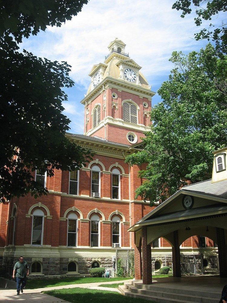
The LaGrange County Courthouse was listed on the National Register of Historic Places in 1980.
Geography
LaGrange is located at 41°38′37″N 85°25′2″W (41.643476, -85.417217).
According to the 2010 census, LaGrange has a total area of 1.7 square miles (4.40 km2), all land.
2010 census
As of the census of 2010, there were 2,625 people, 1,041 households, and 637 families residing in the town. The population density was 1,544.1 inhabitants per square mile (596.2/km2). There were 1,221 housing units at an average density of 718.2 per square mile (277.3/km2). The racial makeup of the town was 93.7% White, 0.6% African American, 0.4% Native American, 0.4% Asian, 4.2% from other races, and 0.7% from two or more races. Hispanic or Latino of any race were 9.5% of the population.
There were 1,041 households of which 33.5% had children under the age of 18 living with them, 43.2% were married couples living together, 13.3% had a female householder with no husband present, 4.7% had a male householder with no wife present, and 38.8% were non-families. 34.3% of all households were made up of individuals and 15.3% had someone living alone who was 65 years of age or older. The average household size was 2.43 and the average family size was 3.17.
The median age in the town was 37.7 years. 27% of residents were under the age of 18; 7.5% were between the ages of 18 and 24; 24.6% were from 25 to 44; 22.9% were from 45 to 64; and 17.8% were 65 years of age or older. The gender makeup of the town was 46.7% male and 53.3% female.
2000 census
As of the census of 2000, there were 2,919 people, 1,149 households, and 716 families residing in the town. The population density was 1,717.8 people per square mile (663.0/km²). There were 1,231 housing units at an average density of 724.4 per square mile (279.6/km²). The racial makeup of the town was 93.32% White, 0.38% African American, 0.03% Native American, 0.48% Asian, 4.69% from other races, and 1.10% from two or more races. Hispanic or Latino of any race were 6.89% of the population.
There were 1,149 households out of which 32.6% had children under the age of 18 living with them, 46.0% were married couples living together, 12.6% had a female householder with no husband present, and 37.6% were non-families. 32.6% of all households were made up of individuals and 15.2% had someone living alone who was 65 years of age or older. The average household size was 2.42 and the average family size was 3.08.
In the town, the population was spread out with 26.6% under the age of 18, 10.0% from 18 to 24, 27.2% from 25 to 44, 19.6% from 45 to 64, and 16.6% who were 65 years of age or older. The median age was 35 years. For every 100 females there were 92.9 males. For every 100 females age 18 and over, there were 82.6 males.
The median income for a household in the town was $32,054, and the median income for a family was $39,038. Males had a median income of $29,545 versus $21,946 for females. The per capita income for the town was $17,865. About 4.7% of families and 7.1% of the population were below the poverty line, including 5.7% of those under age 18 and 9.7% of those age 65 or over.
Courthouse
The LaGrange County Courthouse was designed in 1878 by Thomas J. Tolan, & Son, Architects, of Fort Wayne, Indiana. The courthouse was listed on the National Register of Historic Places on July 17, 1980.
Education
The town of LaGrange lies in the school district of Lakeland School Corporation. The local schools town residents attend are:
Communications
LaGrange has only two numbered state or federal highways: U.S. Route 20 and State Road 9. It is seven miles away from the Howe-LaGrange interchange of the Indiana Toll Road. It has no scheduled airline or passenger rail service.
LaGrange is within the Michiana television market.
Culture
LaGrange has a number of geocaches, wooded trails, and athletic parks, including a skate-park.