
Founded February 10, 1874 Population 53,284 (2013) University Fort Lewis College | Area 4,403 km² Unemployment rate 4.0% (Apr 2015) | |
 | ||
Rivers Animas River, La Plata River, Cascade Creek Points of interest Durango and Silverton, Purgatory Resort, Mesa Verde National, San Juan National Forest, Powerhouse Science Center Destinations Mesa Verde National, Durango, Purgatory Resort, Durango and Silverton, Vallecito | ||
Yeslpc quality of life in la plata county colorado
La Plata County is one of the 64 counties in the U.S. state of Colorado. As of the 2010 census, the population was 51,334. The county seat is Durango. The county was named for the La Plata River and the La Plata Mountains. "La plata" is the Spanish language word for "silver".
Contents
- Yeslpc quality of life in la plata county colorado
- Map of La Plata County CO USA
- Geography
- Adjacent counties
- Demographics
- City
- Towns
- Ghost towns
- National forest and wilderness
- National historic district
- Trails
- Bicycle route
- Scenic byway
- References
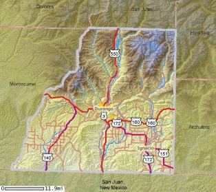
Map of La Plata County, CO, USA
La Plata County comprises the Durango, CO Micropolitan Statistical Area.
The county is home to Durango Rock Shelters Archeology Site, the type site for the Basketmaker II period of Anasazi culture.
Geography
According to the U.S. Census Bureau, the county has a total area of 1,700 square miles (4,400 km2), of which 1,692 square miles (4,380 km2) is land and 7.6 square miles (20 km2) (0.4%) is water.
Adjacent counties
Demographics
As of the census of 2000, there are 43,941 people in the county, organized into 17,342 households and 10,890 families. The population density is 26 people per square mile (10/km²). There are 20,765 housing units at an average density of 12 per square mile (5/km²). The racial makeup of the county is 87.31% White, 5.78% Native American, 0.40% Asian, 0.31% Black or African American, 0.05% Pacific Islander, 3.90% from other races, and 2.25% from two or more races. 10.40% of the population are Hispanic or Latino of any race.
There are 17,342 households out of which 29.60% have children under the age of 18 living with them, 49.90% are married couples living together, 8.70% have a female householder with no husband present, and 37.20% are non-families. 24.80% of all households are made up of individuals and 6.10% have someone living alone who is 65 years of age or older. The average household size is 2.43 and the average family size is 2.92.
In the county, the population is spread out with 22.70% under the age of 18, 13.90% from 18 to 24, 29.00% from 25 to 44, 25.10% from 45 to 64, and 9.40% who are 65 years of age or older. The median age is 36 years. For every 100 females there are 103.60 males. For every 100 females age 18 and over, there are 103.10 males.
The median income for a household in the county is $40,159, and the median income for a family is $50,446. Males have a median income of $32,486 versus $24,666 for females. The per capita income for the county is $21,534. 11.70% of the population and 6.70% of families are below the poverty line. Out of the total population, 9.30% of those under the age of 18 and 7.70% of those 65 and older are living below the poverty line.