
- location Nitchequon - elevation 0 m (0 ft) Basin area 97,600 km² Province Québec Source Lac Nichicun | - location Chisasibi Length 893 km Discharge 1,690 m³/s | |
 | ||
- average 1,690 m/s (59,680 cu ft/s) - max 4,450 m/s (157,150 cu ft/s) - min 345 m/s (12,180 cu ft/s) | ||
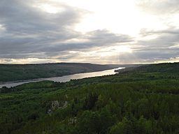
La Grande River (French: La Grande Rivière, Cree: Chisasibi, both meaning "great river") is a river in northwestern Quebec, Canada, which rises in the highlands of north central Quebec and flows roughly 900 kilometres (560 mi) west to drain into James Bay. It is the second largest river in Quebec, surpassed only by the Saint Lawrence River.
Contents
- Map of La Grande RiviC3A8re Baie James QC Canada
- TributariesEdit
- Hydro electric developmentEdit
- References
Map of La Grande Rivi%C3%A8re, Baie-James, QC, Canada
Originally, the La Grande River drained an area of 97,400 square kilometres (37,600 sq mi) and had a mean discharge of 1690 m³/s. Since the 1980s when hydroelectric development diverted the Eastmain and Caniapiscau Rivers into the La Grande, its total catchment area has increased to about 175,000 square kilometres (68,000 sq mi), and its mean discharge increased to more than 3400 m³/s. In November 2009, the Rupert River was also partially diverted, adding another 31,430 square kilometres (12,140 sq mi) to the basin.
At one time, this river was known as the "Fort George River". The Hudson's Bay Company operated a trading post on the river at Big River House from 1803 to 1824. In 1837, a large trading post was established at Fort George on an island at the mouth of the river. In the early 20th century, this trading post became a village as the Crees of the James Bay region abandoned their nomadic way of life and settled nearby. The modern Cree village of Chisasibi, which replaced Fort George in 1980, is situated on the southern shore of the La Grande River, several kilometers to the East.
TributariesEdit
Significant tributaries of La Grande River include:
Hydro-electric developmentEdit
The river has been extensively developed as a source of hydroelectric power by Hydro-Québec, starting in 1974. An area of 9,900 square kilometres (3,800 sq mi) was flooded and almost all of the flow of the Eastmain River and a large portion of the Rupert River were diverted into the La Grande watershed. The following generating stations are on the La Grande River and its tributaries in upstream order:
As a result of the development projects, the Cree people of the region lost some parts of their traditional hunting and trapping territories (about 10% of the hunting and trapping territories used by the Cree of Chisasibi). Organic mercury levels increased in the fish, which forms an important part of their diet, as the organic material trapped by the rising waters in the new reservoirs began to filter into the food chain. Careful follow-up by Cree health authorities since the 1980s has been largely successful. The authorities continue to promote the regular consumption of fish, with the notable exception of the predatory species living in the reservoirs, which still show high levels of mercury.