
Admin. region Schwaben Elevation 512 m (1,680 ft) Area 44.75 km² Local time Saturday 1:33 PM Dialling code 08282 | Time zone CET/CEST (UTC+1/+2) Population 12,564 (31 Dec 2008) Postal code 86381 | |
 | ||
Weather 7°C, Wind SW at 39 km/h, 86% Humidity | ||
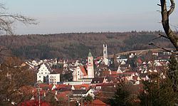
Krumbach (also: Krumbach (Schwaben)) is a town with about 12,500 residents in the district Günzburg in Swabia, Bavaria, Germany. It is the second biggest town in the district.
Contents
- Map of 86381 Krumbach Germany
- Geography
- History
- Coat of arms
- Attractions
- Economy and Traffic and Public Institutions
- Miscellaneous
- Notable births
- References
Map of 86381 Krumbach, Germany
Geography
Krumbach (elevation 512 m (1680 ft)) is situated in Mittelschwaben in the natural region Lower Iller-Lech Gravel Plateau (a part of the region between Danube and the Alps) in the valley of the Kammel, a left tributary of the Mindel river and so an indirect tributary of the Danube river. The landscape is marked by forests and areas in agricultural acreage (fields and grassland).
The next bigger cities respectively towns are Ulm, approximately 40 kilometres northwest of Krumbach, Augsburg, 48 kilometres northeast of Krumbach, Memmingen, about 40 km kilometres southwest of Krumbach, Mindelheim, 30 kilometres south of Krumbach and Günzburg, 27 kilometres north of Krumbach. The distance to Munich is approximately 120 kilometres.
History
In 1156 Krumbach was mentioned in documents the first time, in 1370 the village got the right to hold a market. From 1305 until 1805 Krumbach was part of the Margraviate of Burgau, which was part of the Habsburgian Further Austria. In the year 1805 Krumbach became Bavarian by the Peace of Pressburg. 90 years later Krumbach became a town. In the year 1902 the previously independent municipality Hürben, a neighbouring village of Krumbach, merged into Krumbach. Until the time of the Third Reich Hürben had a high percentage of Jewish residents in comparison to the Bavarian average.
Until 1972 Krumbach was the district seat of the administrative district Krumbach (Swabia).
Bavarian regional reforms merged the previously independent municipalities of Hohenraunau (1972/01/01), Billenhausen with Hirschfelden (1972/07/01), Edenhausen with the Krumbad (1973/01/01), Attenhausen (1977/01/01) and Niederraunau (1978/05/01) into Krumbach.
The Krumbad is a health resort approximately one kilometre east of Krumbach. It is the oldest health resort of Swabia.
Coat of arms
The colours of the town (red and white) as well as the arms (a silver-coloured wavy thick line in red) remind one on the one hand of the long affiliation to Further Austria on the other hand it is a canting arms – the crooked stream. In this context it is important to know, that the meander of the Kammel are clearly distinct.
Attractions
Economy and Traffic and Public Institutions
In Krumbach there are car suppliers, a paintfactory, plant construction factories, weaving mills, waxfactories and a wall-to-wall carpeting factory.
Two Bundesstraßen pass Krumbach: the Bundesstraße 16 (B 16) Günzburg-Mindelheim and the Bundesstraße 300 (B 300) Memmingen-Augsburg. The distances to the Autobahnen 7, 8 and 96 are each approximately 25 kilometres. Furthermore, Krumbach has a railway station at the railway from Günzburg to Mindelheim (Mittelschwaben Railway), a loop line, which connects the main lines Bavarian Maximilian Railway (Munich-Augsburg-Ulm-Stuttgart) and the railway from Munich to Zurich via Buchloe, Memmingen and Lindau (Bodensee).
In Krumbach there are quite a view public institutions: police station, forestry commission office, planning department and several schools: secondary schools, grammar school and vocational schools;
Miscellaneous
In the valley of Günz – approximately six kilometres west of Krumbach there is the Oberrieder Weiher, a flooded gravel pit and popular greenbelt recreation area. At the shores of this lake there is a campingsite, too.