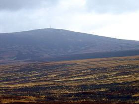
Listing Marilyn, Hewitt Topo map OSi Discovery 56 Elevation 757 m Province Leinster | OSI/OSNI grid O112154 Mountain type granite Prominence 264 m | |
 | ||
Similar | ||
Sota ei ie 005 kippure wicklow ireland
Kippure (Irish: Cipiúr) is a granite mountain that straddles two county boundaries from its peak in Wicklow into South Dublin. It is popular for hill walking and outdoor leisure activity owing to its proximity to Dublin city, with its fine views over Dublin Bay towards Howth Head. It has convenient access and easy terrain. At 757 metres (2,484 feet), it is the 73rd highest in the Republic of Ireland.
Contents
- Sota ei ie 005 kippure wicklow ireland
- Map of Kippure Kippure East Co Wicklow Ireland
- Access
- Watercourses
- Transmission site
- References
Map of Kippure, Kippure East, Co. Wicklow, Ireland
The townland of Kippure is 1,490 acres and occupies the western flank of the mountain. The ridge between the summits of Kippure and Seefingan defines the northern border of the townland, while the River Liffey in the valley below defines the southern border.
Access
Kippure is easily reached by the Military Road which passes close to the summit, with a spur from the road to a 2RN transmitter site at the top.
Watercourses
The slopes of Kippure hold the sources of multiple watercourses, including tributaries that feed the River Liffey, which rises in the Liffey Head Bog on the western slopes of nearby Tonduff Mountain.
Transmission site
At the summit of Kippure stands a 127m television and radio transmitter mast. This is the oldest television transmission site in the Republic of Ireland, and was initially selected as a potential VHF FM radio transmitter site during the course of a Radio Éireann survey in the mid-1950s. The Irish Board of Works built an access road to the site in 1959, and the transmitter installation work was then started by the British company Pye Ltd. By the summer of 1961 the mast was erected and test transmissions followed, consisting of slide views of Ireland, a testcard, and the music of Count John McCormack.
Telefís Éireann began with transmission from Kippure on 31 December 1961 using the British 405-line TV standard on VHF Band III channel 7, to be followed by a 625-line service on channel H in the summer of 1962. Kippure was the first of the original five main Telefís Éireann transmitters to come into service, the others being, Truskmore (1962), Mount Leinster (1963), Maghera (1963), and Mullaghanish (1963)
VHF FM transmission of RTÉ Radio (the former Radio Éireann) commenced in 1966, with stereo broadcasting beginning in 1969.
405-line transmission from Kippure ceased in 1978 with the arrival of RTÉ 2, however Kippure did not transmit RTÉ 2 until much later. Initially on Channel J at low power later moving to Channel H with RTÉ 1 moving to Channel E.
Kippure's importance in radio and television transmission has diminished since the late 1970s with the opening of three new UHF transmitter sites at Three Rock in County Dún Laoghaire–Rathdown, Clermont Carn in County Louth, and Cairn Hill in County Longford, which provide better reception in most areas previously served only by Kippure. Today the Irish DTT service, Saorview, the national FM radio stations, and some commercial radio stations are broadcast from the site.
