
OSI/OSNI grid S826525 Elevation 796 m | Mountain type Granite Prominence 725 m Listing Marilyn | |
 | ||
Similar Arderin, Blackstairs Mountain, Lugnaquilla, Brandon Hill, Mushera | ||
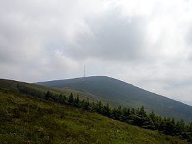
Mount Leinster (Irish: Stua Laighean) is a 796-metre-high (2,612 ft) mountain in the Republic of Ireland. It straddles the border between Counties Carlow and Wexford, in the province of Leinster. It is the fifth-highest mountain in Leinster after Lugnaquilla 925m, Mullaghcleevaun 849m, Tonelagee 817m, and Cloghernagh 800m, and the highest of the Blackstairs Mountains. A 2RN transmission site tops the peak with a mast height of 122 m.
Contents
- Map of Mount Leinster Raheendarragh Co Carlow Ireland
- Access to the summitEdit
- CyclingEdit
- Transmission siteEdit
- Other projectsEdit
- References
Map of Mount Leinster, Raheendarragh, Co. Carlow, Ireland
The transmission site is a popular location for hang gliding and RC Glider enthusiasts to launch from. In 2003, a hang glider pilot died from injuries sustained in the crash landing of his flight launched from the mountain. There is a memorial at the peak of the mountain.
Access to the summitEdit
The mountain is most often climbed from the Nine Stones, a landmark point at the foot of Mount Leinster, about 8 miles east of Borris. From Borris there is a road to a visitor car park on the mountain. From there the steep 2RN access road leads to the summit. This road is closed to normal traffic and 2RN have now fenced off the transmitter mast from public access to prevent vandalism.
The Nine Stones and the car park lie on the saddle between Mount Leinster and the nearby Slievebawn (Sliabh Bán; 52°38′18.6″N 6°48′33.32″W; 520m). There are in fact ten stones. They are arranged in a line and the largest is about 50 cm high. The origin of the stones is uncertain.
CyclingEdit
Mount Leinster has been used in stages of the Tour of Ireland and on many occasions in the FBD Insurance Rás (Rás Tailteann). It may be climbed from the Borris side in County Carlow or the Bunclody side in County Wexford. Ascending from Borris the climb is 11 km long and has an average gradient of 6.9%. The last two kilometres are very tough reaching a gradient of almost 16%. Although the climb from Bunclody is slightly longer at 13 km its average gradient is 5.9%. The last kilometre of this climb is difficult with a gradient of 16.3%. The mountain is also used by The ML Syndicate (mountain biking club) who use the area for trail riding and MTB sporting events .
Transmission siteEdit
The Mount Leinster transmitter is owned and operated by 2RN and at 796m ASL it is the highest transmission site in Ireland. It was one of the original five main Telefís Éireann television transmitters when it opened on low power in December 1962. It became fully operational on 12 June 1963 with a 625-line service on VHF Band III Channel F. The new RTÉ Radio FM service was added in 1966, and RTÉ's second television channel RTÉ 2 was carried on VHF when it started in 1978. UHF television transmissions from Mount Leinster began in 1996 with the introduction of Teilifís na Gaeilge. The original 1962 mast was replaced in 2010 with a taller one of 122m in preparation for digital television transmissions. In common with all the other 2RN sites, analogue television transmissions from Mount Leinster ceased on 24 October 2012. Today the site provides the Irish digital television service Saorview, and eight FM radio stations to a large area of South East Ireland.
Other projectsEdit
Media related to Mount Leinster at Wikimedia Commons