
Listing Hewitt, Marilyn Topo map OSi Discovery 56 Prominence 374 m | OSI/OSNI grid O067070 Elevation 849 m Province Leinster | |
 | ||
Similar | ||
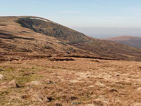
Mullaghcleevaun (from Irish Mullach Cliabháin, meaning 'summit of the cradle') is a mountain in County Wicklow, Republic of Ireland.
Contents
Map of Mullaghcleevaun, Ballynultagh, Co. Wicklow, Ireland
Geography
At 849 m (2,785 ft) tall, the mountain is the second highest of the Wicklow Mountains and the 20th highest in Ireland.
Mullaghcleevaun is believed to have been named after the rounded depression near the summit, which has a small lake (Lough Cleevaun) inside it. Mullaghcleevaun sits roughly in the middle of the Wicklow Mountains and 3 km west of the Military Road. The massif also includes the summit of Mullaghcleevaun East Top (795 m).
Access to the summit
The most common ascent of the mountain is made via Black Hill from the carpark 3 km uphill from the small hillside town of Lacken. The hills of Wales can be seen on a clear day from the triangulation pillar on the summit.