
Area 6,401 km² | Website Official website | |
 | ||
Points of interest Destinations | ||
Kinnaur is one of twelve administrative districts in the Indian state of Himachal Pradesh, India. The district is divided into three administrative areas – Pooh, Kalpa, and Nichar – and has five tehsils (counties). The administrative headquarters of Kinnaur district is at Reckong Peo. From here Kinnaur Kailash, considered to be the abode of Lord Shiva, can be viewed. As of 2011 it is the second least populous district of Himachal Pradesh (out of 12 district), after Lahaul and Spiti, but there are nine vital languages are spoken in the district.
Contents
Map of Kinnaur, Himachal Pradesh
General
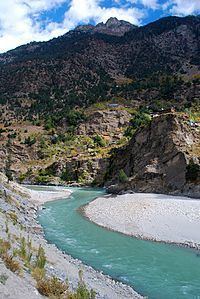
Kinnaur, is about 235 km (146 mi) from the state capital, Shimla, located in the northeast corner of Himachal Pradesh bordering Tibet to the east. It has three high mountains ranges, namely, Zanskar and Himalayas that enclose valleys of Sutlej, Spiti, Baspa and their tributaries. The slopes are covered with thick wood, orchards, fields and picturesque hamlets. At the peak of Kinnaur Kailash mountain is a famous natural rock Shivling (Shiva lingam). The district was opened to outsiders in 1889. The old Hindustan-Tibet Road passes through the Kinnaur valley along the bank of river Sutlej and finally enters Tibet at Shipki La pass.
Geography
A mountainous area, ranging in altitude from 2,320 to 6,816 metres (7,612 to 22,362 ft), Kinnaur is one of the smallest districts in India by population. It is famous for the Kinnaur Kailash, a mountain sacred to Hindus, close to the Tibetan border.
Climate
Most of Kinnaur enjoys a temperate climate due to its high elevation, with long winters from October to May, and short summers from June to September. The lower parts of the Sutlej Valley and the Baspa Valley receive monsoon rains. The upper areas of the valleys fall mainly in the rain-shadow area. These areas are considered to be arid regions, similar to the climate of Tibet. Central Asian landscape are common.
Flora and fauna
Portions of Kinnaur are situated high in the Himalaya, where vegetation is sparse and consists primarily of hardy grasses. Alpine species such as juniper, pine, fir, cypress, and rhododendron can be found at elevations between 3,500 and 5,000 metres, primarily in Middle Kinnaur. At lower altitudes, temperate-climate trees are found, including oak, chestnut, maple, birch, alder, magnolia, apple, and apricot.
Yaks and dzos are reared by local farmers in the higher areas. Scattered populations of the Himalayan black bear and small ponies may also be found.
Demographics
According to the 2011 census Kinnaur district has a population of 84,298, roughly equal to the nation of Andorra. This gives it a ranking of 620th in India (out of a total of 640). The district has a population density of 13 inhabitants per square kilometre (34/sq mi) . Its population growth rate over the decade 2001-2011 was 7.61%. Kinnaur has a sex ratio of 818 females for every 1000 males, and a literacy rate of 80.77%.