
- elevation 2,257 ft (688 m) - average 2,287 cu ft/s (65 m/s) Basin area 4,385 km² | - elevation 184 ft (56 m) Discharge 64.76 m³/s Length 201 km | |
 | ||
- max 91,000 cu ft/s (2,577 m/s) Mouths | ||
The Kings River is a major river of south-central California. About 125 miles (201 km) long, it drains an area of the high western Sierra Nevada and the Central Valley. The headwaters originate at elevations of above 13,000 feet (4,000 m) along the Sierra crest, in and around Kings Canyon National Park. Further west in the foothills, the river is impounded in Pine Flat Lake, before flowing into the Central Valley south of Fresno, where most of its water is used for irrigation. The Kings River was named by the commander of a Spanish military expedition into the Central Valley in 1805.
Contents
- Map of Kings River California USA
- CourseEdit
- Distributaries of the Kings RiverEdit
- HistoryEdit
- EcologyEdit
- River modificationsEdit
- References
Map of Kings River, California, USA
A large alluvial fan has formed where the river's gradient decreases in the Central Valley so the river divides into distributaries. Southern distributaries enter the endorheic basin surrounding Tulare Lake while northern distributaries join the San Joaquin River, eventually reaching San Francisco Bay via the Sacramento–San Joaquin River Delta. Tulare Lake was formerly one of the largest freshwater lakes in western North America, but heavy water diversions have left it dry except in years of exceptionally heavy runoff.
CourseEdit
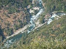
It arises in the Sierra Nevada, consisting of three forks. The Middle and South Forks start in Kings Canyon National Park, while the North Fork starts in the John Muir Wilderness. The South Fork flows in Kings Canyon: a spectacular 8,000-foot (2,400 m) deep glacial valley. The forks join in the foothills of the Sierra Nevada in Fresno County, California, where the river becomes an attraction for whitewater rafting (class 3 rapids). From that point, the Kings River flows about 125 miles (200 km) to the Tulare Lake bed, with a surface elevation at 56 m (184 ft), near Stratford, California. In the foothills, the water from the river is impounded at Pine Flat Dam.
In the Central Valley, the river flows south of Fresno, California, where its water is diverted for agriculture. The river splits into Cole Slough and the Old Kings River at the People's Weir, the largest weir in the Kings River system. The Old River was the main course of the river until two floods in 1861 and 1867, the first of which created Cole Slough and the second of which caused it to become the river's new main course. Since then the Old River has been dry except when river flows are exceptionally high. Dutch John Cut diverges from Cole Slough and joins the Old River to reform the main channel of the Kings River. Cole Slough is then mostly diverted into several canals in the vicinity of Laton. The river system between People's Weir and Laton is collectively known as the Kings River Complex.
The Kings River splits six miles (10 km) north of Lemoore into a set of North and South Fork distributaries. These forks join again nearly five miles (8 km) west of Lemoore. Clark's Fork distributary splits off from the South Fork and flows 5.5 miles (9 km) to join the returning North Fork distributary. The North Fork distributary flows westward to the point where it joins the Fresno Slough, a link to the San Joaquin River when in flood, where its channel turns southwest and rejoins the main channel 6 miles (10 km) west-northwest of Lemoore. The river flows through an artificial channel into the normally dry Tulare Lake bed about ten miles (16 km) south of Stratford.
Distributaries of the Kings RiverEdit
HistoryEdit
The Kings River was named by Lieutenant Gabriel Moraga on one of the first expeditions by the Spanish to the Central Valley of California on January 6, 1805. The river was originally named Rio de los Santos Reyes (River of the Holy Kings) to honor the Biblical Magi. Jedediah Smith named it the Kimmel-che or Wimmel-che "after a tribe of Indians of that name who reside on it".
On the valley floor the Kings River is responsible for certain groundwater recharge. There is evidence in the Hanford area that depths to groundwater are increasing, indicating concern for safe yields of the Tulare Lake groundwater subbasin.
EcologyEdit
North American beaver (Castor canadensis) have recolonized the Kings River including Kings Canyon National Park. Although there is some controversy as to whether beaver were native, fur trapper accounts place beaver in the river before they were trapped out in the late nineteenth century. A 14-man party led by Ewing Young which included Jonathan J. Warner in the fall of 1832 trapped the Kings River "up to and some distance into the mountains and then passed on to the San Joaquin River, trapped that river down to canoe navigation in the foothills, where a canoe was made...". Young and Warner certainly were well above the 1,000 foot level in the Sierras as the headwaters of the San Joaquin River at Martha Lake is less than two miles from the headwaters of the Kings River, above 10,000 feet near Mount Goddard in Kings Canyon National Park and this was the natural route (Hell for Sure Pass) for Ewing and Warner to cross from the source of one river to the other. Williams similarly interpreted accounts of Colonel Warner's expedition, stating that "Warner, had been trapping fur-bearing animals at the headwaters of the Kings River about the same time that the Walker party was descending the Merced River". These interpretations of Young and Warner trapping high up on the Kings River is buttressed by an eyewitness account taken by Tappe from a retired game warden in 1940, who stated that beaver were "apparently not uncommon on the upper part of the Kings River" until 1882-1883.
River modificationsEdit
The Kings River is used to irrigate over 1.2 million acres (5020 km2) and provides water to fourteen Central Valley cities. It is extensively dammed for flood control, irrigation, and power generation. The Pine Flat Dam, built in 1954, impounds the river near Piedra as it flows out of the foothills into the Central Valley. Built by the U.S. Army Corps of Engineers, the dam is 440 feet (130 m) high and stores 1,000,000 acre feet (1.2 km3) of water, and serves mainly to control seasonal flooding. The North Fork is impounded to form Black Rock Reservoir, Wishon Reservoir and Courtright Reservoir. Wishon and Courtright are the lower and upper reservoirs for the Helms Pumped Storage Plant, one of the largest pumped-storage hydroelectric stations in California with a capacity of 1,212 megawatts.
A second large dam on the Kings River, the Rodgers Crossing Dam, was proposed for construction in the late 1980s, upstream from Pine Flat. At a planned height of 600 feet (180 m), it would have backed water up through the foothills for 12 miles (19 km). Environmental and recreational concerns have halted the project thus far.
Further downstream, the Friant-Kern Canal crosses the Kings River approximately 10 miles west of Pine Flat Dam, where water can be turned out into the Kings River through the Kings River wasteway. The canal then continues southwards towards Bakersfield. The purpose of the 152-mile (245 km) channel, which starts on the San Joaquin River and ends at the Kern River, is to provide irrigation water to farms on the east side of the southern San Joaquin Valley. Construction work on the canal lasted from 1945 to 1951.
On the lower river west of Highway 99, since 1959 Kings River Conservation District (KRCD) has worked to protect the flood carrying capacity of Kings River channels and levees. Maintenance efforts have focused on approximately 140 miles (230 km) of levees along the river from below Kingsburg near 8½ Avenue in Kings County to Highway 41 near Stratford on the South Fork of the river, and to McMullin Grade (Highway 145) on the North Fork. During flood releases, KRCD maintains 24-hour patrols monitoring the levee banks for sloughing, erosion and boils.