
Highest elevation 137 m (449 ft) Area 12,516 km² | Area rank 61st Highest point Mount Matheson Elevation 137 m | |
 | ||
Island group Canadian Arctic Archipelago | ||
King William Island (previously: King William Land; Inuktitut: Qikiqtaq) is an island in the Kitikmeot Region of Nunavut, which is part of the Canadian Arctic Archipelago. In area it is between 12,516 km2 (4,832 sq mi) and 13,111 km2 (5,062 sq mi) making it the 61st-largest island in the world and Canada's 15th-largest island. Its population, as of the 2011 census, was 1,279, all of whom live in the island's only community, Gjoa Haven.
Contents
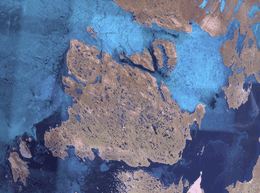
- Map of King William Island Kitikmeot Unorganized NU Canada
- John Ross
- John Franklin
- Roald Amundsen
- References
Map of King William Island, Kitikmeot, Unorganized, NU, Canada
The island is separated from the Boothia Peninsula by the James Ross Strait to the northeast, and the Rae Strait to the east. To the west is the Victoria Strait and beyond it Victoria Island. Within the Simpson Strait, to the south of the island, is Todd Island, and beyond it, further to the south, is the Adelaide Peninsula. Queen Maud Gulf lies to the southwest.
Some places on the coast are: (counterclockwise from the northern tip) Cape Felix, Victory Point and Gore Point at the mouth of an inlet, Point Le Vesconte, Erebus Bay, Cape Crozier, (south side) Terror Bay, Irving Islands, Washington Bay, Cape Herschel, Gladman Point, entrance to Simpson Strait, Todd Islets, (east side) Gjoa Haven, Matheson Peninsula, Latrobe Bay, Cape Norton at mouth of Peel Inlet, Matty Island, Tennent Islands, Clarence Islands, Cape Felix.
The island is known for its large populations of caribou, which summer there before migrating in the autumn by walking south over the sea ice.
While searching for the Northwest Passage, a number of polar explorers visited, or spent their winters on, King William Island.
John Ross
The island was long occupied by Inuit people, who had a culture adapted to the extreme environment. The British explorer John Ross named it "King William Land" for the reigning British King William IV in 1830; he thought at the time that it was a peninsula. In 1834, George Back, another Arctic explorer, viewed its south shore from Chantry Inlet but failed to recognize it as an island. The Franklin Expedition likely recognized it as an island on their retreat to Back's River via Chantry Inlet.
John Franklin
John Franklin, another British explorer, made an Arctic expedition about a decade later; his two ships became stranded in 1845 when frozen in the sea ice northwest of the island. After abandoning the two ships, most of the crew died from exposure and starvation as they attempted to walk south near the western coastline. Two of Franklin's men were buried at Hall Point on the island's south coast. The ships were believed lost forever, as subsequent expeditions were unable to find them.
On 9 September 2014, Canada's Prime Minister Stephen Harper announced that the Victoria Strait Expedition had located one of Franklin's two ships beneath shallow waters south of King William Island. It is preserved in very good condition; the side-scan sonar could detect the deck planking. By the beginning of October, the wreck had been identified as HMS Erebus. The other expedition vessel, HMS Terror, was found in 2016 in Terror Bay, off the south-west coast of King William Island.
Roald Amundsen
In 1903, Norwegian explorer Roald Amundsen, looking for the Northwest Passage, sailed through the James Ross Strait and stopped at a natural harbour on the island's south coast. Unable to proceed due to sea ice, he spent the winters of 1903–1904 and 1904–1905 there. During his stays, he learned Arctic living skills from the local Netsilik Inuit. He used his ship Gjøa as a base for explorations in the summer of 1904, during which he traveled by dogsled on the Boothia Peninsula and to the North Magnetic Pole. After 22 months on the island, Amundsen left in August 1905. The harbour where he lived has the island's only settlement, Gjoa Haven. Amundsen used skills learned from the Inuit when he made his later expedition to the South Pole.