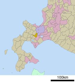
Local time Tuesday 10:42 AM | Population 2,580 (2008) | |
 | ||
Time zone Japan Standard Time (UTC+9) City hall address 123 Kimobetsu, Kimobetsu, Abuta-gun, Hokkaido044-0292 Weather 2°C, Wind SE at 18 km/h, 68% Humidity Points of interest Nakayamatoge Ski Area, Mt Shiribetsu, Kimobetsu Chomin Park | ||
Kimobetsu (喜茂別町, Kimobetsu-chō) is a town located in Abuta District, Shiribeshi Subprefecture, Hokkaido, Japan.
Contents
- Map of Kimobetsu Abuta District Hokkaido Prefecture Japan
- Geography
- Neighboring municipalities
- History
- Climate
- Education
- References
Map of Kimobetsu, Abuta District, Hokkaido Prefecture, Japan
As of 2016, the town has an estimated population of 2,286 and a population density of 12 persons per km². The total area is 189.51 km².
Geography
Route 230 and Route 276 cross each other in Kimobetsu. Nakayama Pass is on the eastern of the town.
The name derived from Ainu word "kim-o-pet", meaning "The river in the mountain".
Neighboring municipalities
History
Climate
Due to its mountainous location, Kimobetsu has a humid continental climate (Koppen Dfb). Summers are generally warm and wet, while winters are cold and extremely snowy.
Education
References
Kimobetsu, Hokkaido Wikipedia(Text) CC BY-SA
