
Population 666 (2001 Census) Civil parish Killin Local time Monday 8:51 PM | OS grid reference NN572328 Sovereign state United Kingdom | |
 | ||
Weather 9°C, Wind S at 31 km/h, 97% Humidity Points of interest | ||
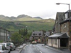
The village of killin scotland
Killin (/ˌkɪlˈɪn/; from Cill Fhinn 'the White [or Fair] Church' in Gaelic) is a village situated at the western head of Loch Tay in Stirling (formerly Perthshire), Scotland.
Contents
- The village of killin scotland
- Map of Killin UK
- Falls of dochart killin scottish highlands scotland
- History
- Events
- References
Map of Killin, UK
The west end of the village is magnificently sited around the scenic Falls of Dochart, the main street leading down towards the Loch at the confluence of the rivers Dochart and Lochay. The falls are crossed by a narrow, multi-arched stone bridge carrying the main A827 road into Killin.
Killin railway station was on the Killin Railway. The railway station was officially closed on 1 November 1965.
Killin has a small primary school with 56 pupils. For secondary education the children have to travel to Callander, 21 miles to the south. The nearest Gaelic medium primary is in Stirling, 37 miles to the south.
Falls of dochart killin scottish highlands scotland
History
The MacNab Clan were once dominant here, and have long been associated with Killin. Their ancient burial ground is on Inchbuie in the River Dochart, just below the falls, and is visible from the bridge.
Kinnell House was the seat of the MacNabs. A well-preserved prehistoric stone circle (possibly 'restored' to improve its appearance) known as Killin Stone Circle can be seen in the grounds of the house. To the north of the village lie the ruins of the Campbells of Breadalbane stronghold of Finlarig Castle, with its associated chapel. The growing power of the Campbells eventually ousted the MacNabs, who lost Kinnell House to their rivals. In 1694 Sir John Campbell of Glenorchy, 1st Earl of Breadalbane established Killin as a Burgh of barony. In 1949 Kinnell House and its estate returned to the ownership of the Chief of Clan Macnab, but in 1978 death duties forced the then Chief, James Charles Macnab of Macnab, to sell most of the estate.
In 1767 the minister of Killin, James Stuart, published the first New Testament in Scottish Gaelic.
By the end of the 18th century there was a local linen industry. Flax was grown locally, spun in small mills and woven into linen by home based weavers. Today, Killin services the local rural community and the growing tourism and leisure industries. In addition to walking on Ben Lawers National Nature Reserve, fishing for trout and salmon there are various watersports available on Loch Tay. Many local vernacular buildings have been preserved or converted, allowing the village to retain much of its historic character.
The 19th century Moirlanich Longhouse in nearby Glen Lochay is a rare surviving example of the cruck frame Scottish longhouse, and is now in the care of the National Trust for Scotland. The former Breadalbane Folklore Centre in the Victorian mill by the falls displays the 'healing stones' of Saint Fillan.
Tomnadashan Mine, an abandoned copper mine overlooking the village, is sometimes identified as the haunt of the Rabbit of Caerbannog of Monty Python and the Holy Grail fame. Nearby Glen Lochay is the mysterious location to which Richard Hannay, played by Robert Donat, heads in the 1935 Alfred Hitchcock film of The 39 Steps.
Events
The village hosts the annual Killin Music Festival in June of each year. The festival was relaunched in 2016 by a local voluntary team.