
Ocean/sea sources Atlantic Ocean. Max. length 16 km (9.9 mi) Ocean/sea source Atlantic Ocean | Basin countries Ireland Average depth 45 m (148 ft) | |
 | ||
Location County GalwayCounty Mayo. | ||
Wild atlantic way killary harbour signature point
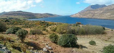
Killary Harbour/An Caoláire Rua is a fjard located in the west of Ireland in the heart of Connemara which forms a natural border between counties Galway and Mayo. It is 16 kilometres long and in the centre over 45 metres deep. It is one of three glacial fjards that exist in Ireland, the others being Lough Swilly and Carlingford Lough.
Contents
- Wild atlantic way killary harbour signature point
- Map of Killary Harbour Ireland
- Scenic drive killary harbour leenane connemara ireland
- References
Map of Killary Harbour, Ireland
On its northern shore lies the mountain of Mweelrea, Connacht's highest mountain, rising to 814 metres. To the south rise the Maumturk Mountains and the Twelve Bens. The area contains some of Ireland's most awe-inspiring and dramatic scenery.
There are two minor settlements nearby. On the southern side near the mouth of the fjard lies the hamlet of Rossroe while Leenaun lies inland to the east. Close to Rosroe there is an old building which now houses a hostel. This building was formerly a modest house which was used by Ludwig Wittgenstein, the famous philosopher, as a quiet place to write shortly after World War II. A plaque acknowledging this was unveiled by President Mary Robinson in 1993.
Nearby lies the so-called Green Road, a rough road running along the side of the fjard back east towards Leenane at the head of the fjard. It stretches for approximately nine kilometres and was part of the famine relief program during the 19th century. Aquaculture is important locally with a salmon farm based at Rossroe while mussel rafts are a common sight more to the east.