
Pronunciation /mwiːlˈreɪ/ OSI/OSNI grid L789668 Elevation 814 m Province Connacht | Location County Mayo, Ireland Topo map OSi Discovery 37 Prominence 778 m Listing Marilyn | |
 | ||
Translation smooth bald hill (Irish) Similar Ben Gorm, Benbaun, Nephin, Croagh Patrick, Lugnaquilla | ||
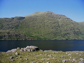
Mweelrea (/mwiːlˈreɪ/; from Irish Cnoc Maol Réidh, meaning 'smooth bald hill') is a mountain in County Mayo, Ireland. It is the highest mountain in Connacht.
Contents
Map of Mweelrea, Derry, Co. Mayo, Ireland
Geography
With a height of 814 metres (2,670 feet), the mountain is the highest point in the province of Connacht and the 34th highest in the island of Ireland. The mountain overlooks Killary Harbour.
Mweelrea is a mountain overlooking the Atlantic coast, and as such weather conditions can change very rapidly and this poses particular challenges for climbers who are inexperienced or have limited navigation abilities. From the east the mountain is well protected by outlying ridges and boggy ground as well as a cliff line to the east of the main summit.
Access to the summit
The easiest ascent is probably by starting on the coast to the west of the mountain and ascending gentle slopes, but even from this side climbers need to navigate carefully as cloud or mist can obscure the summit very rapidly. Access across land/farms may be a problem from this side however so climbers need to consult with local landowners before entering land there. The summit does provide stunning views of the surrounding area, including views of County Galway and Mayo, and the Atlantic Ocean.