
Elevation 4,693 m | ||
 | ||
Similar Babusar Pass, Fairy Meadows, Rakaposhi, Baltit Fort, Nanga Parbat | ||
Khunjerab Pass or Khunjerav (elevation 4,693 metres or 15,397 feet) is a high mountain pass in the Karakoram Mountains in a strategic position on the northern border of Pakistan's Gilgit–Baltistan Hunza – Nagar District on the southwest border of the Xinjiang region of China. Its name is derived from two words of the local Wakhi language : 'Khun' means Home and 'Jerav' means a creek coming from spring water/water falling.
Contents
- Map of Kunjirap Daban Tashkurgan Kashgar China
- Silk road travel between pakistan and china at khunjerab pass
- Sino Pakistani border crossing
- Railway
- References
Map of Kunjirap Daban, Tashkurgan, Kashgar, China
Silk road travel between pakistan and china at khunjerab pass
Sino-Pakistani border crossing
The Khunjerab Pass is the highest paved international border crossing in the world and the highest point on the Karakoram Highway. The roadway across the pass was completed in 1982, and has superseded the unpaved Mintaka and Kilik Passes as the primary passage across the Karakoram Range. The choice of Khunjerab Pass for Karakoram Highway was decided in 1966: China citing the fact that Mintaka would be more susceptible to air strikes recommended the steeper Khunjerab Pass instead.
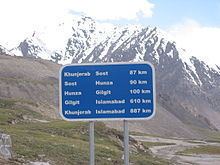
On the Pakistani side, the pass is 42 km (26 mi) from the National Park station and checkpoint in Dih, 75 km (47 mi) from the customs and immigration post in Sost, 270 km (170 mi) from Gilgit, and 870 km (540 mi) from Islamabad.
On the Chinese side, the pass is the southwest terminus of China National Highway 314 (G314) and is 130 km (81 mi) from Tashkurgan, 420 km (260 mi) from Kashgar and some 1,890 km (1,170 mi) from Urumqi. The Chinese port of entry is located 3.5 km (2.2 mi) along the road from the pass in Tashkurgan County.
The long, relatively flat pass is often snow-covered during the winter season and as a consequence is generally closed from November 30 to May 1.
Since June 1, 2006, there has been a daily bus service across the boundary from Gilgit, to Kashgar, Xinjiang
This is one of the international borders where left-hand traffic (Pakistan) changes to right-hand traffic (China) and vice versa.
Railway
In 2007, consultants were engaged to investigate the construction of a railway through this pass to connect China with transport in Pakistani-administered Gilgit-Baltistan. A feasibility study started in November 2009 for a line connecting Havelian 750 km (466 mi) away in Pakistan and Kashgar 350 km (217 mi) in Xinjiang.