
Type sedimentary Named by E. O. Ulrich, 1911 | Unit of Helderberg Group Named for Keyser | |
 | ||
Thickness 33 m at Allegheny Furnace Extent | ||
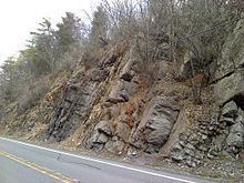
The Late Silurian to Early Devonian Keyser Formation is a mapped limestone bedrock unit in Pennsylvania, Maryland, Virginia, and West Virginia.
Contents
Description
The Keyser is a nodular limestone overlain by thick- and thin-bedded limestone and laminated limestone at its type locality in Keyser, West Virginia.
In central Pennsylvania, the basal "calico" limestone is a fossiliferous, medium-light- to medium-gray very thick bedded calcilutite containing numerous small irregular patches of clear calcite. The abundantly fossiliferous, nodular limestone at the base overlies the "calico". Overlying this is 5 to 6 m of fragmental calcarenite containing abundant crinoid columnals. Above the calcarenite is 6 m of fossiliferous, banded calcisiltite. The uppermost 15 m is a sequence alternating between laminated, stromatolitic calcisiltite, and calcilutite and calcisiltite that are argillaceous and fossiliferous.
Depositional Environment
The depositional environment of the Keyser is interpreted as shallow marine and tidal flats, occurring in cycles.
Stratigraphy
Contact with Tonoloway Formation is probably conformable, but sharp enough to suggest an unconformity. Upper contact with the Old Port Formation is conformable.
The Keyser was divided into three members by J. W. Head in 1972. These are, from lowest to highest, the Byers Island Member, Jersey Shore Member, and La Vale Member. The type locality of the Byers Island Member is at Selinsgrove, Pennsylvania, where it is 93 feet thick. The type locality of the Jersey Shore Member is at Jersey Shore, Lycoming County, Pennsylvania. The type locality of the La Vale Member is at the Corriganville quarry, Allegany County, Maryland, and is named from nearby town of La Vale. This nomenclature is accepted by the USGS.
In Virginia and West Virginia the Keyser is divided into Upper and Lower Members by the Big Mountain Shale Member.
Fossils
Notable Exposures
Age
Relative age dating places the Keyser in the late Silurian to early Devonian, with the transition occurring near the top of the formation. Denkler and Harris used conodont biostratigraphy to confirm this.