
Length 216.8 km | ||
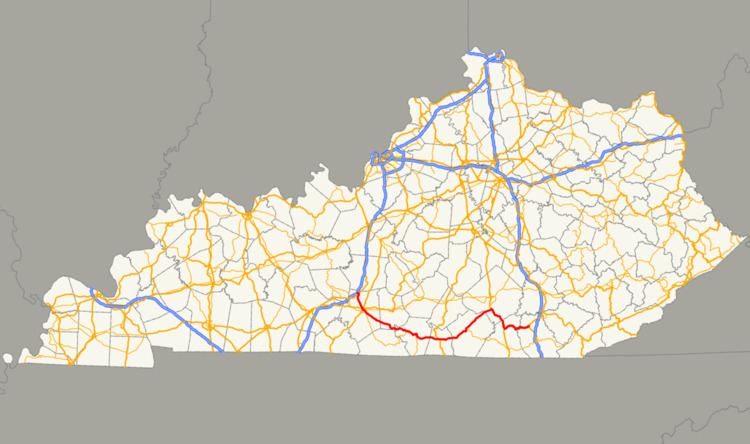 | ||
Kentucky Route 90 is a major east-west state highway in southern Kentucky. The route is 134.734 miles (216.833 km) long, and it traverses Barren, Metcalfe, Cumberland, Clinton, Wayne, Pulaski, McCreary and Whitley Counties in southern Kentucky. It originates near the KY 70 junction with Interstate 65 in Cave City and ends at a junction with US 25W at Youngs Creek.
Contents
- Map of KY 90 Kentucky USA
- Barren and Metcalfe Counties
- Cumberland and Clinton Counties
- Wayne County and beyond
- Points of interest along the route
- Roller Coaster Fair
- The early days 1929 1960
- The modern days 1960 present
- Glasgow truck route
- Monticello business route
- Kentucky Route 90 Spur
- Glasgow alternate route
- References
Map of KY-90, Kentucky, USA
Barren and Metcalfe Counties
Kentucky Route 90 begins at Cave City at an intersection with KY 70, equipped with a traffic light, in the one part of the city where many restaurants, hotels, and gas stations are located. It is a major tourism hot-spot due to the close proximity to Mammoth Cave National Park, in nearby Edmonson County, along with few other attractions along KY 70 west of the city. Signs at the I-65 exit tend to imply that KY 90 ends at the exit itself, while state highway documents indicate that the end is at the intersection with KY 70, about 100 yards (91 m) from the exit proper. In spite of this, both KY 70 and KY 90 markers appear on the signage for Exit 53 of I-65. After KY 90's first mile, it intersects U.S. Route 31W, still within city limits of Cave City.
KY 90 then heads into a south-southeasterly path to the Barren County seat, Glasgow, where it crosses the Veterans Outer Loop (US 68) passes the local Walmart and a local Marquee Cinema, and then has junctions with US Highways 31E and 68 Business, which is co-joined with Kentucky Route 80 in this area. It also has an intersection with US 31E's business loop at the Barren County courthouse. Before leaving the city of Glasgow, KY 90 has an intersection with the Louie B. Nunn Cumberland Parkway at the exit 14 interchange on the southeastern side of the city.
After leaving Glasgow, the highway continues in a southeasterly fashion and passes through the small town of Eighty Eight, and then goes into southern Metcalfe County, and passes through Summer Shade.
Cumberland and Clinton Counties
KY 90 enters Cumberland County, and passes through Marrowbone and the county seat, Burkesville. After going through Burkesville, KY 90 turns due east, crosses the Cumberland River, and has intersections with short roads leading to Dale Hollow Lake State Park, and then goes into Clinton County, where, for about 1.5 miles (2.4 km), it is co-joined with US 127, which is the core route of the annual World's Longest Yard Sale (a.k.a. The Highway 127 Corridor Sale), which takes place in early August.
Wayne County and beyond
KY 90 then goes through more rural areas and then into Wayne County where it intersects Kentucky Route 92 at Monticello. The state highway continues into a northeasterly course towards Mill Springs, the site of a famous Civil War battle site, and a mill built in 1877 (accessible via KY 1275). It enters the southern portion of Pulaski County. The highway's concurrency with US 27 begins after KY 90 crosses the Cumberland River for a second time (except the river at that point would still be part of Lake Cumberland) near Burnside, Kentucky. KY 90 runs concurrently with U.S. 27 for about 14.6 miles (23.5 km) from Burnside to Parkers Lake. This stretch of road is the gateway to General Burnside State Park After departing US 27 in northern McCreary County, KY 90 is the main route that accesses Cumberland Falls State Resort Park. At the route's terminus in the Whitley County community of Young's Creek, there is a 0.32 mile-long (0.51 km) spur called KY 90S that serves as a secondary entrance to the highway for northbound traffic on U.S. 25W. The road is signed as KY 90, however.
Points of interest along the route
These are points of interest that can be accessible along this route:
Roller Coaster Fair
Kentucky Route 90 from Cave City to just north of Albany, along with Kentucky Route 63 from Glasgow to Tompkinsville, Kentucky, along with US Route 127 in Clinton County, and Tennessee state highways 52, 111, and 51 are designated as the marked route for the annual Roller Coaster Fair, a long route-based yard sale event held the first weekend of October.
The early days (1929-1960)
KY 90 was established in 1929 as one of the charter routes of the Kentucky State Highway System. The highway's original western terminus was located in downtown Glasgow at a junction with KY 80 (which at the time was not co-signed with US 68 in this area until the 1940s). Along the route, it connected to certain areas via two ferries, one at Burkesville, and the other at the Whitley/McCreary County line near Cumberland Falls. KY 90's eastern terminus was at a junction with US 25W, but at the time it was in downtown Corbin at the Whitley/Laurel County line. Sometime between 1940 and 1955, US 25W was rerouted to its current route, and KY 90's eastern end was relocated to an area between Corbin and Cumberland Falls. A bridge near the falls was built sometime during that time frame so KY 90 traffic would not be bombarded with rapids that affected ferry service.
Also during the 1950s, KY 90 was extended northwestward from its previous terminus in downtown Glasgow, to a junction with U.S. Route 31W, which at the time was south of Cave City. The road that KY 90 took over, Happy Valley Road, was previously signed as Kentucky Route 351.
The modern days (1960-present)
At sometime between 1969 and 1973, KY 90 from the KY 685 junction to US 31W was rerouted to make KY 90 go directly into Cave City. KY 90's western terminus was also relocated to its current west end at a then-new junction with KY 70 near the I-65 exit 53 interchange, thus extending KY 90 by another 0.8 miles (1.3 km), and providing westbound KY 90 traffic direct access to I-65.
In 2013, KY 90 between the Cumberland Parkway junction and the Eighty Eight community was reconstructed to add truck-climbing lanes in two spots. Reconstruction of KY 90 continued from that area to the Metcalfe County line, and was completed by Fall 2015. In September and October 2014, the first 0.4 miles (0.64 km) of KY 90, along with the KY 70 overpass over I-65 (the latter of which began in 2013), were both reconstructed and were widened to four lanes, plus a center lane for left turns.
Some talks between the KYTC and Stantec are taking place to widen an 8.4 miles (13.5 km) stretch of KY 90 from Cave City to Glasgow to either a 2+1 type of road (two lanes plus the turning lane in the center) or a complete 4-laner with a 40 miles (64 km) median. Plans for it are still yet to be placed on the agenda. Opinions of locals are being used for consideration before the project even happens.
Glasgow truck route
Kentucky Route 90 Truck is a truck route in Glasgow, Kentucky.
The following is a list of routes that are the component routes of KY 90 Truck:
Additionally, US 68 Truck accompanies this truck route in its entirety.
Monticello business route
Kentucky Route 90 Business is a business route of KY 90 in Monticello, Kentucky. It was the original route of KY 90 until the regular KY 90 was re-routed to the Monticello By-Pass.
The entire route is in Wayne County.
Kentucky Route 90 Spur
Kentucky Route 90 Spur (KY 90S) is a spur route of KY 90 in rural northern Whitley County. Although this route is not signed, the route connects KY 90 with U.S. Route 25W just south of KY 90's eastern terminus east of Cumberland Falls. KY 90S is 0.318 miles (0.512 km) long, and it is said to be the original alignment of KY 90's final 0.374 miles (0.602 km).
Glasgow alternate route
In Glasgow, at one time, Alternate KY 90 ran from the US 31E bypass junction with KY 90, continuing as Happy Valley Road, to the intersection with Business Route 31E (North Race Street), and follows the US 31E business route until it reaches the Barren County Courthouse, where KY 90 runs (while being co-signed with US 68 and KY 80, a.k.a. West Main Street). Sometime in the 2000s, that designation was decommissioned. The regular KY 90 became co-signed with US 31E (L. Roger Wells Blvd) from that intersection to the junction with US 68/KY 80, and KY 90 followed US 68 and KY 80 to the Public Square.