
Max. width 0.75 km (0.47 mi) Area 1,160 km² Width 750 m | Max. length 15 km (9.3 mi) Surface elevation 260 m Length 15 km | |
 | ||
Primary inflows Primary outflows Mississippi River to Mud Lake | ||
Triple rock wall jump on kashwakamak lake
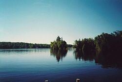
Kashwakamak Lake is a freshwater lake in North Frontenac, Frontenac County, Ontario, Canada. It is located east of Cloyne, and southeast of Bon Echo Provincial Park.
Contents
- Triple rock wall jump on kashwakamak lake
- Map of Kashwakamak Lake North Frontenac ON Canada
- Dji phantom 4 kashwakamak lake dam
- References
Map of Kashwakamak Lake, North Frontenac, ON, Canada
The lake is 15 kilometres (9 mi) long, 0.75 kilometres (0.5 mi) wide, has a surface area of 1,159.8 hectares (2,866 acres) with a rocky shoreline and a maximum depth of 22 metres (72 ft), and lies at an elevation of 260 metres (853 ft). The primary inflow and outflow is the Mississippi River, upstream from Marble Lake over the Whitefish Rapids, and downstream, controlled by the Kashwakamak Lake Dam, towards Mud Lake.
This lake is home to a variety of fish species including Largemouth bass, Northern pike, Smallmouth bass, Rock bass, Pumpkinseed, Walleye, and Yellow perch. It is also home to private cottages as well as Aragain Lodge, Fernleigh Lodge, Swing Wright, Twin Oaks Lodge, and Woodcrest Resort Park.
The Ministry of Environment Self Help Program makes it possible along with the Lake Partner Program to provide water quality testing by the Members of the Lake Association volunteers. The Mississippi Valley Conservation Authority has a Watershed Watch Program which provides the comparison of water testing which has taken place since 1976 to present day.