
Elevation 280 m | Local time Tuesday 11:15 AM | |
 | ||
- summer (DST) Eastern Time Zone (UTC-4) Weather 5°C, Wind S at 13 km/h, 92% Humidity | ||
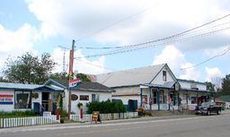
Cloyne is a small village in the township of Addington Highlands, Lennox and Addington County, Ontario, Canada. It is located on Ontario Highway 41 about 20 kilometres (12 mi) by road north of Kaladar at the crossroads of Highway 41 with Ontario Highway 7, with the settlements of Bishop Corners and Northbrook in between, and 43 kilometres (27 mi) by road south of Denbigh, with the settlements of Ferguson Corners and Vennachar Junction in between.
Map of Cloyne, ON, Canada
The village offers a number of services for residents, snowmobilers, cottagers and campers, particularly those visiting Bon Echo Provincial Park to the north on Highway 41. There are also number of small shops, providing townspeople and visitors access to groceries, antiques, chainsaw carvings, hardware supplies, gas, and hunting and fishing gear. Cloyne is also home to the North Addington Education Centre and a Pioneer Museum. The northern end of the village features an oversized wooden white lawnchair, which is able to comfortably seat well over a dozen tourists for photograph opportunities.