
Prominence 1,827 m (5,994 ft) Last eruption 2009 | Elevation 1,827 m | |
 | ||
Similar Soputan, Dukono, Mount Lokon, Mount Gamkonora, Lewotobi | ||
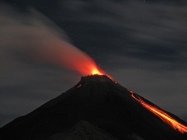
Karangetang lava flows and rock falls
Karangetang (also known as Api Siau) is a volcano located on the north side of Siau Island off the coast of Sulawesi, Indonesia. The island is inhabited by 22,000 people. It is one of the most active volcanoes in Indonesia having erupted forty-one times since 1675. A pyroclastic flow in 1997 killed three people.
Contents
- Karangetang lava flows and rock falls
- Map of Karangetang Mini North Siau Barat Siau Tagulandang Biaro Regency North Sulawesi Indonesia
- Puncak gunung karangetang siau
- Current activity
- References
Map of Karangetang, Mini, North Siau Barat, Siau Tagulandang Biaro Regency, North Sulawesi, Indonesia
Puncak gunung karangetang siau
Current activity
In August 2007 an eruptive episode forced evacuations from nearby areas.
On 9 June 2009 the Volcanological Survey of Indonesia raised the eruption alert status of Karangetang to Level Orange.
On 6 August 2010 Karangetang again erupted, spewing lava and ash hundreds of meters into the air. Four villagers are missing.
On 11 March 2011, a few hours after an earthquake in Japan caused a Pacific-wide tsunami, Mount Karangetang again erupted. There were no reports of serious damage or deaths, though lava and hot gas clouds were emitted onto its slopes.
On September 2, 2013, the volcano began erupting again.