
Elevation 1,580 m Prominence 842 m | Last eruption 2015 | |
 | ||
Similar Mount Mahawu, Soputan, Karangetang, Mount Klabat, Dukono | ||
Mount lokon tomohon gunung lokon tomohon
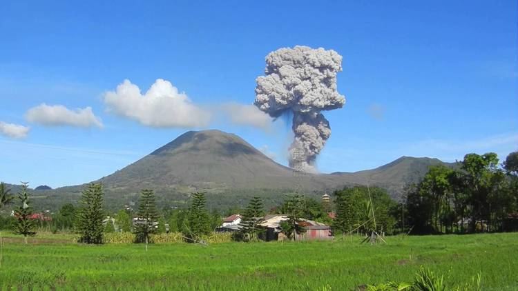
Mount Lokon, together with Mount Empung, is a twin volcano (2.2 km or 1.4 mi apart) in the northern Sulawesi, Indonesia, roughly 10 km (6 mi) south of Manado. Both rise above the Tondano plain and are among active volcanoes of Sulawesi. Mount Lokon has a flat and craterless top. Its active crater is located on its foot, named "Tompaluan" crater.
Contents
- Mount lokon tomohon gunung lokon tomohon
- Map of Mount Lokon Kayawu North Tomohon Tomohon City North Sulawesi Indonesia
- References
Map of Mount Lokon, Kayawu, North Tomohon, Tomohon City, North Sulawesi, Indonesia
Lokon formed during a period of andesitic volcanism on ring fractures resulting from the Tondano caldera's early to mid-Pleistocene collapse. Recently erupted material remains andesitic in composition and consists of ash plumes and, less commonly, pyroclastic flows and lava domes.
The volcano erupted on 15 July 2011, forcing thousands of people to evacuate.
The volcano again began showing signs of activity on 10 February 2012, and 19 September 2012 (11:01pm). An eruption occurred at 8:20, am the same day sending an ash plume two miles into the sky. Local residents have been evacuated from a two and a half mile exclusion zone around the volcano. An eruption occurred on 17 December 2012.
Indonesia has 129 volcanoes including Mount Lokon. The eruption of Mount Lokon in 1991 killed a Swiss hiker and forced thousands of people to flee their homes.