
- Flower Sakura Population 38,120 (1 Sep 2015) | Region ChūbuTōkai Area 65.16 km² Local time Friday 8:33 AM | |
 | ||
Weather 8°C, Wind SW at 21 km/h, 65% Humidity Points of interest Jukkokutōge Cable Car, Dairy kingdom Oratche, Tanna Fault, Kannami Sports Park, Oaresan | ||
Kannami (函南町, Kannami-chō) is a town located in Tagata District, Shizuoka Prefecture, Japan. As of September 2015, the town had an estimated population of 38,120 and a population density of 585 persons per km². The total area was 65.16 square kilometres (25.16 sq mi).
Contents
- Map of Kannami Tagata District Shizuoka Prefecture Japan
- Geography
- Neighboring municipalities
- History
- Economy
- Education
- Railway
- Highway
- Sister city relations
- Noted people from Kannami
- References
Map of Kannami, Tagata District, Shizuoka Prefecture, Japan
Geography
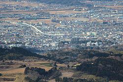
Kannami is located in an inland area in far eastern Shizuoka Prefecture, in the foothills of the Hakone Mountains. The Kano River passes through the town. Kannami has a temperate maritime climate with hot, humid summers and mild, cool winters.
Neighboring municipalities
History
During the Edo period, all of Izu Province was tenryō territory under direct control of the Tokugawa shogunate. During the cadastral reform of the early Meiji period in 1889, the village of Kannami was created within Tagata District, Shizuoka Prefecture. On April 1, 1962, it was elevated to town status.
Economy
The economy of Kannami is primarily based on agriculture. Major products include strawberries, cucumbers and dairy products. The town is also a bedroom community for neighboring Mishima.
Education
Kannami has five elementary schools, two middle schools and two high schools.