
- elevation 2,076 ft (633 m) Length 110 km | - elevation 600 ft (183 m) | |
 | ||
Similar Alatna River, Tinayguk River, Endicott Mountains, Kobuk River, Birch Creek | ||
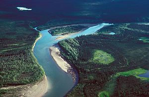
The John River is a 125-mile (201 km) tributary of the Koyukuk River in the northern part of the U.S. state of Alaska. It was named after John Bremner, a prospector and explorer who was one of the first non-native persons to go there. It flows south from Anaktuvuk Pass in Alaska's Brooks Range, into the larger river at a point near Bettles, slightly north of the Arctic Circle.
Contents
Map of John River, Alaska, USA
In 1980, the 52-mile (84 km) segment of the John River within the Gates of the Arctic National Park and Preserve were designated "wild" and added to the National Wild and Scenic Rivers System. The designation means that the segment is unpolluted, free-flowing, and generally inaccessible except by trail.
The John River Valley is an important migration route for Arctic caribou.
Boating
It is possible to run the John River in canoes, kayaks, and small rafts, though conditions vary from place to place. The upper 35 miles (56 km) are rated Class III (difficult) on the International Scale of River Difficulty and "should be attempted only by experienced paddlers with solid wilderness skills." Below this, the river is rated Class II (medium) for the next 47 miles (76 km), then Class I on the lower reaches all the way to the mouth. Dangers on the upper river include sustained whitewater, swift currents, a difficult 4-mile (6 km) portage, and the possibility of water too shallow to run.