
Country United States of America | Elevation 8,976 ft (2,736 m) Period Cretaceous | |
 | ||
Length 700 mi (1,100 km) East-west Width 150 mi (240 km) North-south Mountains | ||
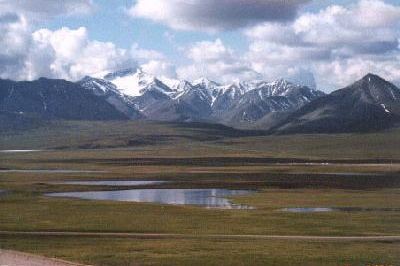
Dogteams racing development in alaska s brooks range
The Brooks Range (Athabaskan Gwazhał) is a mountain range in far northern North America stretching some 700 miles (1,100 km) from west to east across northern Alaska into Canada's Yukon Territory. Reaching a peak elevation of 8,976 feet (2,736 m) on Mount Isto, the range is believed to be approximately 126 million years old.
Contents
- Dogteams racing development in alaska s brooks range
- Map of Brooks Range Alaska USA
- Peaks
- Ecology
- Paleontology
- Climate
- Films
- References
Map of Brooks Range, Alaska, USA
In the United States, these mountains are considered an extension of the Rocky Mountains, whereas in Canada they are considered separate, the northern border of the Rocky Mountains regarded as the Liard River far to the south in the province of British Columbia.
While the range is mostly uninhabited, the Dalton Highway and Trans-Alaska Pipeline System run through the Atigun Pass (1,415 m, 4,643 ft) on their way to the oil fields at Prudhoe Bay on Alaska's North Slope. The Alaska Native villages of Anaktuvuk and Arctic Village, as well as the very small communities of Coldfoot, Wiseman, Bettles, and Chandalar Lake, are the range's only settlements. In the far west, near the Wulik River in the De Long Mountains is the Red Dog mine, largest zinc mine in the world.
The range was named by the United States Board on Geographic Names in 1925 after Alfred Hulse Brooks, chief USGS geologist for Alaska from 1903 to 1924.
Various historical records also referred to the range as the Arctic Mountains, Hooper Mountains, Meade Mountains and Meade River Mountains; the Canadian portion is still often referred to as the British Mountains, a part of Ivvavik National Park.
Peaks
Ecology
The Brooks Range forms the northernmost drainage divide in North America, separating streams flowing into the Arctic Ocean and the North Pacific. The range roughly delineates the summer position of the Arctic front. It represents the northern extent of the tree line, with little beyond isolated Balsam poplar stands occurring north of the continental drainage divide. Trembling aspen and white spruce also occur north of the Brooks Range, though they are limited to sites that have been disturbed by human activity. Southern slopes have some cover of Black Spruce, Picea mariana, marking the northern limit of those trees. As one of the most remote and least-disturbed wildernesses of North America, the mountains are home to Dall sheep, grizzly bears, and caribou.
In Alaska, the 490,000 animal strong (in 2004) Western Arctic Caribou herd traverses the Brooks Range in its annual migration. The smaller Central Arctic herd (32,000 in 2002), as well as the 123,000 animal Porcupine Caribou herd, likewise migrate through the Brooks range on their annual journeys in and out of the Arctic National Wildlife Refuge. The migration path of the Porcupine Caribou Herd is the longest of any terrestrial mammal on earth.
Paleontology
Because it is heavily composed of ancient seabed, the Brooks Range contains ancient marine and other fossils. In addition to the coral fossils shown at left, trilobites and brachiopods from the middle Cambrian have been found in the sandy limestones of the Central Brooks Range.
Climate
While other Alaskan ranges to the south and closer to the coast can receive 250 inches (640 cm) to 500 inches (1,300 cm) of snow, the average snow precipitation on the Brooks Range is reported at 30 inches (76 cm) to 51 inches (130 cm).
As measured at the Anaktuvuk Pass weather station (elevation 770 metres (2,530 ft)), the average summer temperatures are 3 °C (37 °F) as a low and 16 °C (61 °F) as a high. During the winter the average low is −30 °C (−22 °F) while the average high is −22 °C (−8 °F).