
Length 135.2 km | ||
 | ||
East end: SR 56 Spur northeast of Shell Bluff | ||
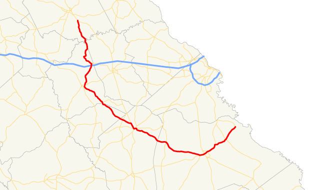
State Route 80 (SR 80) is a 84.0-mile-long (135.2 km) state highway that predominantly runs in a west–east direction in the east central part of the U.S. state of Georgia. It exists within portions of Wilkes, Warren, Glascock, Jefferson, and Burke counties.
Contents
Map of State Rte 80, Warrenton, GA 30828, USA
Route description
SR 80 begins at an intersection with US 78/SR 10/SR 17, southeast of Washington in Wilkes County. It heads south-southeast and crosses over the Little River at the meeting point of Wilkes, Warren, and McDuffie counties. For approximately 2 miles (3.2 km), the highway runs along the Warren–McDuffie county line, then enters Warren County proper. In Cedar Rock, it intersects the western terminus of SR 223. Almost immediately is an interchange with Interstate 20 (I-20). Then, it heads southwest, passing through Camak, and heads toward Warrenton. Just before entering the city limits, it intersects the northern terminus of SR 80 Alternate (VFW Road). In town it has an intersection with US 278/SR 12/SR 80 Alternate. This intersection also marks the eastern terminus of US 278 Bypass/SR 12 Bypass. US 278 Bypass/SR 12 Bypass/SR 80 begin a concurrency around the southeast edge of town. Approximately 2,000 feet (610 m) later, SR 80 splits off to the southeast. It intersects the western terminus of SR 17 Connector (Purvis School Road) on the Warren–Glascock county line. It passes through rural areas of Glascock County, without any major intersections, and crosses into Jefferson County. SR 80 continues to the southeast, intersecting SR 296, before meeting SR 17. The two highways head concurrent into Wrens. At the intersection with SR 102, which heads west-northwest, SR 80 departs to the east on Stapleton Highway. About two blocks later is US 1/US 221/SR 4/SR 88 (Main Street), SR 80/SR 88 head to the east. At Waynesboro Road, SR 80 splits off to the south-southeast. It passes through rural areas of the county and passes into Burke County. The route curves to the east and meets SR 305. It curves to the southeast before heading east-southeast. The highway begins a concurrency with SR 24 just before entering Waynesboro. About 1,000 feet (300 m) later, SR 56. At the intersection with US 25/SR 121 (Liberty Street), SR 24 turns right, while SR 56/SR 80 continue through town. They meet US 25 Bypass/SR 121 Bypass. The two highways continue to the northeast, and curve to the north-northeast, before splitting. SR 80 heads northeast and intersects SR 23 in the unincorporated community of Shell Bluff. The highway continues to the northeast, until it meets its eastern terminus, an intersection with SR 56 Spur, northeast of Shell Bluff.
SR 80 is not part of the National Highway System, a system of roadways important to the nation's economy, defense, and mobility.
Bannered route
State Route 80 Alternate (SR 80 Alt.) is a 2.1-mile-long (3.4 km) alternate route that exists entirely within the north central part of Warren County.
It begins at an intersection with US 278/SR 12, as well as US 278 Byp./SR 12 Byp./SR 80, in the east-central part of Warrenton. Starting at its southern terminus, SR 80 Alt. is concurrent with US 278/SR 12 to the east. The three highways curve to the northeast and intersect V.F.W. Road. Here, SR 80 Alt. departs to the northwest. It heads northwest and curves to the northwest until it meets its eastern terminus, an intersection with the SR 80 mainline, northeast of Warrenton.
SR 80 Alt. is not part of the National Highway System, a system of roadways important to the nation's economy, defense, and mobility.
The entire route is in Warren County.