
Flag of Jefferson Seal of Jefferson Demonym Jeffersonian Capital Yreka | Official language English Largest city Roseville Area 190,768 km² | |
 | ||
Population Ranked 36th (hypothetical) | ||
The State of Jefferson is a proposed U.S. state that would span the contiguous, mostly rural area of southern Oregon and Northern California, where several attempts to separate from Oregon and California, respectively, have taken place.
Contents
This region on the Pacific Coast is the most famous of several that have sought to adopt the name of Thomas Jefferson, the third President of the United States. Jefferson, who sent the Lewis and Clark expedition into the Pacific Northwest in 1803, envisioned the establishment of an independent nation in the western portion of North America that he dubbed the "Republic of the Pacific"; hence, the association of his name with regional autonomy. The independence movement, rather than statehood, is known as Cascadia.
The name "Jefferson" has also been used for other proposed states: the name was proposed in the 19th century for Jefferson Territory (roughly modern Colorado), as well as in 1915 in a bill in the Texas legislature for a proposed state that would be created from the Texas Panhandle region.
If the proposal were ever approved, the new State's capital city would have to be determined by a constitutional convention. Yreka, California, was named the provisional capital in the original 1941 proposal, although Port Orford, Oregon, had also been up for consideration. Some supporters of the more recent revival have also identified Redding, California, as a potential capital, even though Redding is not included in all versions of the proposal and its own city council voted in 2013 to reject participation in the movement.
20th century
In October 1941, the mayor of Port Orford, Oregon, Gilbert Gable, said that the Oregon counties of Curry, Josephine, Jackson, and Klamath should join with the California counties of Del Norte, Siskiyou, and Modoc to form a new state, later named Jefferson.
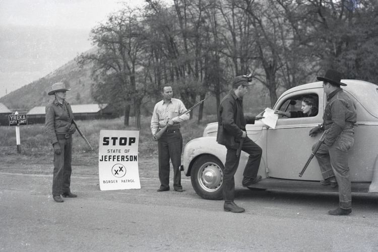
On November 27, 1941, a group of young men gained national media attention when, brandishing hunting rifles for dramatic effect, they stopped traffic on U.S. Route 99 south of Yreka, the county seat of Siskiyou County, and handed out copies of a Proclamation of Independence, stating that the state of Jefferson was in "patriotic rebellion against the States of California and Oregon" and would continue to "secede every Thursday until further notice."
The state split movement ended quickly, though not before Del Norte County District Attorney John Leon Childs (1863-1953) of Crescent City was inaugurated as the governor of the State of Jefferson on December 4, 1941. The first blow was the death of Mayor Gable on December 2, followed by the attack on Pearl Harbor on December 7. Those in favor of splitting the state focused their efforts on the war effort, which crippled the movement. Coincidentally, the "state of Jefferson" was one of the few places in the continental USA to be the subject of an attack during World War II, when Japanese pilot Nobuo Fujita dropped bombs on the Oregon Coast near Brookings on September 9, 1942. San Francisco Chronicle journalist Stanton Delaplane won the 1942 Pulitzer Prize for Reporting for his articles on the State of Jefferson.
In 1992, State Assemblyman Stan Statham placed an advisory vote in 31 counties asking if the state should be split into two. All of the proposed Jefferson counties voted in favor of the split (except Humboldt County which did not have the issue on the ballot.) Based on these results, Statham introduced legislation in California in an attempt to split the state, but the bill died in committee.
21st century
Jefferson is commemorated by the State of Jefferson Scenic Byway between Yreka and O'Brien, Oregon, which runs 109 miles (175 km) along State Route 96 and U.S. Forest Service Primary Route 48. Near the California – Oregon border, a turnout provides scenic views of the Klamath River valley and three informative display signs about the republic. The region retains this identity reinforced by institutions such as Jefferson Public Radio.
As of the 2010 Census, if the Jefferson counties were a state (original 1941 counties), the state's population would be 457,859: smaller than any state at the time. Approximately 82% of those residents live in Oregon. Its land area would be 21,349.76 square miles (55,295.6 km2) – a little smaller than West Virginia. The area was almost evenly divided between Oregon and California. Its population density would be 21.44 inhabitants per square mile (8.28/km2) – a little more than Idaho. With the addition of the more modern Jefferson movement (Coos and Douglas and Lake Counties in Oregon, and Humboldt, Trinity, Shasta, Lassen, Mendocino, Lake, Tehama, Plumas, Glenn, Butte, Colusa, Sierra, Sutter County, Yuba, Nevada, Placer and El Dorado Counties in California), the population as of the 2010 Census would be 2,313,958, making it the 36th most populous state in the US.
In 1989, KSOR, the National Public Radio member station based at Southern Oregon University in Ashland, near Medford, rebranded itself as Jefferson Public Radio. It had built a massive network of affiliated radio stations over the previous decade, and the network's management had decided to promote its service area as generally coextensive with the original State of Jefferson land region.
The recent movement for statehood started on September 3, 2013, when the Siskiyou County Board of Supervisors voted 4–1 in favor of withdrawal from California to form a proposed state named Jefferson. The proposal was joined by the Modoc County Board of Supervisors (September 24) and Glenn County Board of Supervisors (January 21, 2014). On April 15, 2014 Yuba County supervisors joined the State of Jefferson movement to separate from California and create a new state of Jefferson. On July 15, 2014 the Tehama County Board of Supervisors voted unanimously to adopt a resolution supporting the declaration of withdrawal from California based on an advisory vote taken on June 6, 2014 where the public voted 56% to 44% in favor of splitting the state. On July 22, 2014 the Board of Supervisors of Sutter County unanimously adopted a resolution supporting a declaration and petition to the Legislature to withdraw from California to redress a lack of representation. On March 3, 2015, Lake County supervisors voted 3-2 to submit the question of secession to voters and on March 17, Lassen County supervisors made a similar declaration that also has the voters deciding in 2016. The Jefferson Declaration Committee is reportedly aiming to get at least 12 counties in support.
On October 24, 2014, Modoc and Siskiyou Counties delivered their declarations for independence from the state of California to the California Secretary of State's office. On January 15, 2015, three more counties, Glenn, Tehama, and Yuba, submitted their official declarations as well.
The current revival is based almost entirely in California. It includes virtually all of California north of 39°. Although some individual residents in Oregon have lobbied for the movement, no county government in that state has endorsed the proposal to date. As of January 6, 2016, 21 northern California counties have sent a declaration or have approved to send a declaration to the State of California with their intent of leaving the state and forming the State of Jefferson. The population of the 21 California counties alone was 1,747,626 as of the 2010 census, which would be 39th most populous.
After the 2016 presidential election, it was noted that most of the rural California counties which would belong to the State of Jefferson were won in a landslide by Republican nominee Donald Trump, whereas Democrat Hillary Clinton enjoyed a virtually unprecedented level of support in the rest of California, indicating a growing demographical and political divide between the proposed State of Jefferson and the rest of California. While Clinton beat Trump by almost 80 points in San Francisco, he led her by more than 50 points in Lassen County. The election of Trump led to calls for a secession of California and a similar proposal in Oregon, where Clinton won the popular vote while Trump captured the majority of counties.
Flag and seal
The field of the flag is green, and the charge is the Seal of the State of Jefferson: a gold mining pan with the words "The Great Seal Of State Of Jefferson" engraved into the lip, and two Xs askew of each other. The two Xs are known as the "Double Cross" and signify the two regions' "sense of abandonment" from the central state governments, in both Southern Oregon and Northern California.