
Area 4,038 km² Average annual precipitation 987 | State Uttar Pradesh Website Official website Literacy 71.6% | |
 | ||
University Veer Bahadur Singh Purvanchal University Points of interest Shahi Bridge - Jaunpur, Jaunpur Fort, Atala Mosque - Jaunpur, Jama Mosque - Jaunpur, Trilochan Mahadev Temple | ||
Jaunpur district is a district in the Varanasi Division in the state of Uttar Pradesh, India. Jaunpur is the administrative centre. It lies in eastern part of state. Jaunpur City is situated at the bank of Gomati river. District have 2 Lok sabha, one Rajya Sabha and 9 Vidhan Sabha seats. According to 2011 census report Jaunpur have 1024 female on per thousand male which is highest in Uttar Pradesh.
Contents
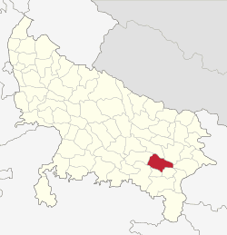
- Map of Jaunpur Uttar Pradesh
- History
- Sharqi empire
- Lodi dynasty
- Mughal empire
- Freedom Struggle
- Atala mosque
- Jhanjhari mosque
- Jama mosque
- Lal Darwaza mosque
- Shahi Pul
- Shahi Qila
- Other historic buildings of the district
- Geography
- Rivers
- Climate
- Topography
- Geology
- Economy
- Agriculture
- Industry
- Demographics
- Divisions
- Tahsils
- References
Map of Jaunpur, Uttar Pradesh
History
Well known for its past and the glory of learning Jaunpur holds its own important historical, social and political status. Studying its past on the basis of panic accounts, rock edicts, archaeological remains and other available facts, the continuous existence of Jaunpur district is seen, in some form of the other, till the Late Vedic Period. The glory of the city on the Adi Ganga Gomti and its peaceful shores was a major pious ground for the meditations and contemplations of sages, Rishis and Maharshis from where the sounds of the vedmantras emanated. Even today, the Deva Vanees are echoing in temples along the banks of the Gomti in Jaunpur city.
Sharqi empire
In 1194 A.D., Qutubuddin Aibak attacked Mandev or Mandeya (present day Jafrabad). After defeating the then king Udaypal, he entrusted power to Dewanjeet Singh and headed towards Banares. In 1389 A.D., Mahmood Shah, the son of Feroze Shah ascended the throne. He made Sarbar Khwaja a minister and, later in 1393 A.D. gave him the little of Malik-ul-Sharq and entrusted him with the area from Kannauj to Bihar. Malik-ul-sharq made Jaunpur his capital and established his reign from Etawah to Bengal and Vindhyachal to Nepal. The founder of the Sharqi Dynasty, Malik-ul-sharq, died in 1398 A.D. Whereupon, his foster son Saayed Murakshah ascended the throne of Jaunpur. His younger brother Ibrahimshah succeeded him to the thorne. Ibrahimshah proved to be an accomplished and able ruler. He implemented the policy of good will with the Hindus. During the Sharqi period, many grand buildings, mosques and mausoleums were built. Ferozeshah had lain the foundations of the Atala Mosque in 1393 A.D. but it was completed by Ibrahim shah in 1408 A.D. Ibrahim shah got started the construction of Jama Masjid and Bari Masjid which were completed by Husainshah. The unique aspect of Hindu-Muslim communal harmony which had been present during the Sharqi Parishad in Jaunpur district- which has held an important position in the fields of Education, Culture, Music, Arts and Literature- its fragrance exists even today.
Lodi dynasty
The Lodhi Dynasty held the reins of power on the throne of Jaunpur from 1484 A.D. to 1525 A.D.
Mughal empire
To conquer Jaunpur, Babar sent his son Humayun, who defeated the ruler of Jaunpur. Upon the death of Humayun in 1556 A.D. his 18 years old son Akbar ascended to throne. In 1567 A.D. when Ali Kuli Khan rebelled, then Akbar himself attacked and Ali Kuli Khan was killed in the battle. Akbar stayed for several days at Jaunpur. Thereafter, he went back after appointing Sardar Muneem Khan as the ruler. It was during the reign of Akbar that the Shahi Bridge (Jaunpur) was built.
In 1722 A.D. after being a part of the Mughal Sultanat for a century and a half, Jaunpur was entrusted to the Nawab of Awadh. Later in 1775 A.D. Jaunpur too, along with Benares went into the hands of the English from the king of Benares, Mansaram. From 1775 to 1788 A.D. Jaunpur was under the dominion of Benares and then it was in the hands of the Regiment Dekana. For the first time in 1818 A.D. the Deputy Collectorateship was established and later it became a separate district. In 1820 A.D., Azamgarh district was also brought under Jaunpur but some part of Azamgarh in 1822 and the whole of Azamgarh in 1830 A.D. was separated from Jaunpur
Freedom Struggle
Jaunpur of the British period has been a witness to rebellion against the power of the state. For the 1857 revolution, posters had been put up everywhere on 31 May. Instructions had been issued to the native soldiers to deposit their arms. The news of the rebellion reached Jaunpur from Benares on the 5th of June, 1857. On September 8, the Gorkha forces arrived in Jaunpur from Azamgarh. On account of this, all the civilian officers who had fled to Benares returned to Jaunpur. The northwest part of Jaunpur was in the flames of the rebellion. The confrontation of the freedom fighters under the leadership of Mata Badal Chauhan with the English Forces took place. The English hanged Mata Badal Chauhan and his 13 confederates. In this conflict, these braves killed one Sergeant Brigade, a legal officer.
Before the arrival of Mahatma Gandhi in India, Pathakji was an associate of Gandhiji in South Africa in Gandhiji's non co-operation movement against the white people there. Later, he too came over here and joined the freedom struggle.
In Itaha village of Machhalishahar, the famouns freedom fighter was the elder brother of Pt. Shiva Varna Sharma.In the turmoil 1857 A.D., about ten thousand people of Jaunpur were martyred. In 1885, the Indian National Congress was established. A decade later, the first meeting of the Congress in the city was held in Urdu Mohalla.
In the non-cooperation movement of Gandhi in 1920, Jaunpur took part with verse and zeal. During this period Motilal Nehru, Smt. Sarojini Naidu, Jawahar Lal Nehru, Madan Mohan Malviya too toured the district and held meetings.In October 1929, Mahatma Gandhi too toured Jaunpur.
72 people were put on trial and sentenced. Rebellion under the Quit India Movement started in the district on the 10th of August, 1942. On the 11th of Auct, 1942, several leaders of congress, students, youth and shopkeepers took out a Rally in Jaunpur city and at noon, a massive crowd entered the Collectorate premises and tried to unfurl the Tricolour Flag.
On 16 August 1942 while demolishing the Dhaniyamau Bridge, conflict raged between the police and the revolutionaries in the course of which to students of Singramau Jamindar Singh & Ram Adhar Singh along with Ram Padarath Chauhan and Ram Nihore Kahar became the victims of police bullets. A fair is held in Dhaniyamau at the Shahid Smarak on the 16th August every year in their memory.In Machhalishahar and Uchaura, 11 people died and 17 were injured by Army's firings. Along with Hargovind Singh, Deep Narain VErma, Mujtaba Hussain and other important leaders, 196 people were arrested and sent to jails.
Atala mosque
Firoz Shah III began the construction of the Atala mosque in 1393 .Atala mosque is model of Indo-Iran architecture.The Atala became a model for other mosques in the Jaunpur district. Architecturally, it retained and advanced the element of monumentalism. The height of the Atala mosque is over 100 feet (30 m). The perimeter is 248 feet (76 m). The entrance has three massive stone pylons. The central one consists of a high arch between two sloping towers. These are decorated with arched niches and stone screened windows.
Jhanjhari mosque
The Jhanjhari mosque, on the north bank of the Gomti river, was built by Ibrahim in the Sipah locatility of Jaunpur township. It was a residence of Ibrahim himself, as well as a place for saints, scholars (pandits) and the army (who kept animals such as elephants, camels, horses and mules). After human destruction and flood damage, only the facade remains. This consists of an arch, 35 feet (11 m) high and 32 feet (9.8 m) wide. Some of the stones from this mosque were used in the construction of the Shahi bridge.
Jama mosque
The Jama mosque is another of the Sharqi dynasty period, started by Ibrahim and after a number of construction phases, completed by Hussain. It is located on the Shahganj road near the Purani bazaar at Madiyahun. The size of the mosque interior is 219 feet (67 m) x 217 feet (66 m). 27 steps climb to the top. There are four gates, one at each cardinal point. The eastern gateway was destroyed by Sikander Lodhi. The mosque is decorated with Egyptian style engravings and lotus, sunflower and rose motifs.
Lal Darwaza mosque
Lal Darwaza Masjid, Jaunpur|This Mosque was built in 1447 (as per inscription of this mosque) at Begumganj, 1 mile (1.6 km) north of Jaunpur, during the reign of Sultan Mahmud Sharqi, by Queen Bibi Rajyi, dedicated to Maulana Sayyid Ali Dawood Kutubbudin, a celebrated saint (Maulana) of Jaunpur, whose descendent still live in the mohalla bazaar bhua Pandariba Jaunpur and mohalla Namaz Gah laldarwaza.. The mosque occupies 212 square feet (19.7 m2) x 188 square feet (17.5 m2) and has three entrances and a courtyard. It is also known as the "Red Portal Mosque".
Shahi Pul
The Shahi Pul is a bridge over the Gomti river at Jaunpur township. It was built by Khankhana in 1564 for Akbar. The bridge is 26 feet (7.9 m) wide. At each end were pillboxes to house stalls. On a square platform in the middle of the bridge, there is a large sculpture of a lion with an elephant underneath its forepaws. The statue originated in a Buddhist monastery. There is an associated mosque at Idgah on the Allahabad road.
Shahi Qila
In 1162, Firoz Shah III built the Shahi Qila (the imperial fort). The Kerar Kot fort once stood on the same site in Jaunpur township on the left (north) bank of the Gomti river. It contained a mosque and a spacious and stylish set of baths (hammam) installed by Ibrahim, Firoz's brother. The layout of the fort is an irregular quadrangle enclosed in stone walls. The walls surround raised earthworks. Most of the remains of the original structures are buried or in ruin.
The main gates face east. The largest inner gate is 14 metres (46 ft) in height. Its external surface is set with ashlar stone. A further, outer, gate was installed during the reign of the Mughal king, Akbar, under the patronage of the governor of Jaunpur, Min'im Khan in the 16th century. It is designed in the shape of a flanking bastion. The spandrels or spaces between the arches of the outer gate were decorated with blue and yellow tiles. Ornamental niches are built into the walls of the outer gate.
The two story residential and administrative building or "palace" was built in a square layout. An interior pillared verandah or aiwan overlooked the ground floor from the first.
The mosque or masjid is likely the oldest building in Jaunpur township. It was a simple arcade of about 39.40 metres (129.3 ft) x 6.65 metres (21.8 ft). It was supported by pillars in the Bengali style. There are three low central domes and no minars. (There are two nearby stone pillars instead).
Other historic buildings of the district
Geography
The district of Jaunpur is situated in the North-West part of Varanasi Division.Its attitude varies from 261 ft to 290 ft. above Sea Level.
Rivers
Gomti and Sai are its main parental rivers. Besides these, Varuna, Basuhi, Pili. Mamur and Gangi are the smaller rivers here. The rivers Gomti and Basuhi divide the district into nearly four equal landmasses.Jaunpur district is often affected by the disaster of floods.
Climate
Jaunpur district has a climate consistent with that of the Northern Plain and Central Highlands including the Aravalli range, hot semi-arid eco-region 4.3 and hot dry ecoregion 9.2. The temperature varies between about 4 °C (39 °F) and 44 °C (111 °F). The annual normal rainfall is 1,098 millimetres (43.2 in). The monsoon season occurs from the third week of June to the first week of October. Normally, there are 46 rain days per year of which 31 occur in the monsoon season. The district regularly suffers drought and pestilence.
Topography
The topography of the district is a flat plain undulating with shallow river valleys. The main permanently flowing rivers are the Gomti and the Sai. The rivers of Jaunpur flow from northwest to southeast and the land slopes in the same direction. Thus, there is a more elevated area in the northwest and a less elevated area of land in the south east.
Geology
Beneath the surface of the district of Jaunpur, is a thick mantle consisting of the quaternary sediments (silt, sand and clay) of the Ganga river system. Below is vindhya range bedrock. Mineral deposits are rare but there is limestone as a conglomerate kanker in nodular and block forms. The lime can be used in building. Earthquakes have been recorded, the largest in 1927 and 1954.
Economy
Distrist's main economical activity is agriculture and allied sector. Jaunpur is fastest developing area in eastern uttar pradesh with skill development, quality education and good infrastructure .
Agriculture
The main field crops of Jaunpur district are: rice, maize, pigeon pea, pearl millet, blackgram wheat and chickpea. Other crops are onion and potato and crops for fodder. The crops are grown with both rainfall and irrigation. There are cattle (both local low yielding and crossbred), and local low-yielding buffalo as well approximately 29% of Jaunpur's population is employed.Approximately 40% of those employed work in manufacturing, 26% work in trade and commerce, 19% work in other services, 8% work in transport and communication, 4% work in agriculture, 2% work in construction, and 2% are marginal workerss goats, sheep, backyard chickens and pigs and occasional dairy farms. There are 43 government reservoirs and many more private water sources. At Gujartal lake, 2 miles (3.2 km) west of Kheta Sarai, pisciculture is conducted.
Industry
There is little heavy industry in Jaunpur. The Varanasi Jaunpur highway allows for some industrial economic development. A cotton mill is operational near Karanja Kala and there are some textile manufacturers. Other manufactured products include perfume (jasmine oil and attar) and incense, furniture, carpets, chemical fertiliser and cement. Tertiary and service industries include repair workshops, print shops and internet cafes., There is a special economical zone located at Allahabad road near Mungra Badshahpur the Sathariya Industrial area or SIDA. Although all units of SIDA is not in function but maximum are doing work. Jaunpur have problem of infrastructure development. Like many other districts of eastern uttar pradesh Jaunpur have poor road quality and lack of electricity supply. National highway number 56 between Lucknow and Varanasi cross from Jaunpur.
Demographics
In 2011, an official census was made in Jaunpur district. It recorded a population of 4,476,072 of which 2,258,437 were female and 2,217,635 male. Jaunpur district has population density of 1,113 persons per sq. km.Between 2001 and 2011, the population of Jaunpur district grew 14.89%. Literacy increased from 59.84 to 73.66 percent. In 2011, 86.06 percent of men were literate and 61.7 percent of women.Children under six years formed 14.37% of the population.
Jaunpur ranks 7th in terms of population in the state and ranks 1st in terms of sex ratio (1,024).There are 663,513 households in the district accounting for 2% of the total households in the U.P. The average size of households in the district is 6.8 persons.Urban population in the district is only 7.7% of total population
Divisions
Within the district, there are 2 national lower house constituencies, Lok Sabha, of which Jaunpur constituency is entirely in the district, and 9 state lower house constituencies, Vidhan Sabha. Jaunpur district has six administrative subdivisions (Tahsils).
Tahsils
Jaunpur district is further divided into twenty-one "development blocks".
There are also twenty-seven police districts (Thanas).