
Area 3,122 km² | Website Official website Average annual precipitation 1,102 | |
 | ||
Landscape from lattu pahar simultala or shimultala jamui district bihar india
Jamui is one of the 38 districts of Bihar state, India. The district was formed on 21 February 1991, when it was separated from Munger district. It is located at a longitude of 86° 13'E and the latitude is 24° 55'N.
Contents
- Landscape from lattu pahar simultala or shimultala jamui district bihar india
- Map of Jamui Bihar
- History
- Jamui District Bihar
- Geography
- Tourism
- Economy
- Administrative units
- Demographics
- Transport
- Museum
- Music
- Literature
- Flora and fauna
- Sports
- References
Map of Jamui, Bihar
History
Various literature indicates the fact that Jamui was known as Jambhiyaagram. According to Jains, the 24th Tirthankara lord Mahavira attained omniscience (Kevala Jnana) in Jambhiyagram situated on the bank of river named Ujjihuvaliya. Another place traced as "Jrimbhikgram" on the bank of Rijuvalika river, resembles Jambhiyagram, Ujjhuvaliya.
The Hindi translation of the words Jambhiya and Jrimbhikgram is Jamuhi which is developed in the recent time as Jamui. With the passage of time, the river Ujhuvaliya /Rijuvalika is supposed to be developed as the river Ulai and as such both the place are still found in Jamui . The Ulai river is still flowing nearby Jamui. The old name of Jamui has been traced as Jambhubani in a copper plate which has been kept in Patna Museum. This plate clarifies that in the 12th century, Jambudani was today's Jamui. Thus, the two ancient names as Jambhiyagram and Jambubani prove that this district was important as a religious place for Jains, and it was also a place of Gupta Empire. In the 19th century; the historian Buchanan also visited this place in 1811 and found the historical facts. According to other historians Jamui, was also famous in the era of the Mahabharata.
According to available literature, Jamui was related to Gupta and Pala rulers before the 12th century. But after that this place became famous for Chandel rulers. Prior to Chandel Raj, this place was ruled by Nigoria, who was defeated by Chandels and the dynasty of Chandela founded in the 13th century. The kingdom of Chandels spread over the whole of Jamui.
The district is currently a part of the Red Corridor.
Jamui District Bihar
Geography
Jamui district occupies an area of 3,098 square kilometres (1,196 sq mi), comparatively equivalent to Indonesia's Yamdena Island. The district has untapped reserves of resources including mica, coal, gold and iron ore.Situated along the Bihar-Jharkhand border, Jamui is dotted with hills and the small retreat town of Simultala falls within the Jhajha block, on the main Delhi-Howrah rail line. The town of Gidhaur, situated 17 kilometres (11 mi) away was the seat of kings during the British Raj and many buildings from the period still survive. Minto Tower in Gidhaur is a prime example of architecture from the period.
Tourism
Jain Mandir Lachhuar:This is a large and old rest house(Dharmsala) of 65 rooms constructed for the Jain Pilgrims. There is a Mandir of Lord Mahavira inside the Dhamsala. The idol in this temple is more than 2,600 years old. This black stone idol is of weighs around 250 kg. This is situated on the way of kshatriya Kund Gram, the birthplace of LordMahavira. This place is located in Sikandra Block which is approx 20 km. west from Jamui District Headquarter.ncn
Giddheswar Temple:Famous temple of lord Shiva situated on the top of stone boulders. It 15 km south from the district headquarter.
Simultalla hill station:This place is famous for its beautiful scenic hills and pleasant weather.It is supposed to be the Tapo-Bhumi of Sri Ramakrishna Paramhans, who founded TaraMath of Devi Bhagvati.
Kali Mandir Malaypur:Temple of goddess Kali is situated at village Malaypur, block Barhat. A very famous festival known as Kali Mela is held every year at this place. The temple is just near by the Railway station, Jamui.
Minto Tower Gidhaur:Minto tower was built by the Maharaja of Gidhaur in 1909 to commemorate the visit of the then British Viceroy Lord Irwin to Gidhaur. It is in the middle of Gidhaur Market on the main Jamui-Jhajha state highway.
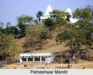
Patneswar Mandir:This is famous temple of lord Shiva situated on the way of Station Road Jamui. It is about 5 km north from the district headquarter Jamui.
Maa netula temple This is famous Temple of Maa Ambe Situated at village kumar, block sikandra. it is about 26 km west form the district headquarter jamui bihar.
Bhim Bandh: It is located between Lakshmipur and Haveli Kharagpur Jungle. So many source of hot water at this place. This is a famous picnic spot in winter season from October to February.
Economy
In 2006 the Ministry of Panchayati Raj named Jamui one of the country's 250 most backward districts (out of a total of 640). It is one of the 36 districts in Bihar currently receiving funds from the Backward Regions Grant Fund Programme (BRGF).
Administrative units
- No. of Police District 1
- No. of Sub-Divisions 1
- No. of Police Sub-Divisions 2
- No. of Blocks 10
- No. of Circles 10
- No. of Police Stations 12
- No. of Panchayats 153
- No. of Villages 1,528
Demographics
According to the 2011 census Jamui district has a population of 1,756,078, roughly equal to the nation of The Gambia or the US state of Nebraska. This gives it a ranking of 273rd in India (out of a total of 640). The district has a population density of 567 inhabitants per square kilometre (1,470/sq mi) . Its population growth rate over the decade 2001-2011 was 25.54%. Jamui has a sex ratio of 921 females for every 1000 males, and a literacy rate of 62.16%.
Transport
Jamui Railway Station, station code JMU, is one of the major railway stations in Danapur division of East Central Railway. Jamui is connected to metropolitan areas of India, by the Delhi-Kolkata Main Line via Mugalsarai-Patna route which runs along the historic Grand Trunk road.
Jamui Station serves the headquarters of Jamui district in the Indian state of Bihar. Railways and roads are the main means of transport in the region.The Jamui railway station is in Howrah-Patna-Mughalsarai main line. Most of the Patna, Barauni bound express trains coming from Howrah, Sealdah, Ranchi, Tatanagar stop here.
Museum
Chandrashekhar Singh Sangrahalay
Founded on 16 March 1983. Total number of archaeological remains in this museum is 178. Various statues of Lord Vishnu, Lord Bhudha,. Goddess Uma, Durga, Surya, ancient rocks and terracotta seals etc. are available.
Music
The musical tradition of the district was rich in the past and is getting enriched in present times also. In the past two the decades Sri Bajrang Lal Gupta has worked as an A.I.R. artist of light classical music. Sri Jyotrindra Kumar, Dr. Anjubala, Smt.Sujata Kumari, Kumar Amitabh, Sri Chandan Gupta, Sri Shailesh Kumar, Smt. Abha Singh, Sri Anil Pathak, Chandan Singh, D.D Singh etc. are making a significant contribution towards the upliftment of music in Jamui district. Shasi Ranjan Prasad is a classical dancer.
Literature
Jamui has been a fertile ground for man of literature and poets. Dr.Prof.Awadh Kishore Sinha, Dr.Shyamanand Prasad have held the flag of literature high. This has been ably kept up and continued by young poets and writers such as Prof Dr. Jagrup Prasad, Prof. Dr. Sunil Yadav, Prof. Sukhdev Thakur, Prof. Naheed Badar, Prof. Prabhat Sarsij, Dr. Giridhar Acharya, Lect. Babita singh,Prof. Brajnandan Modi. Jamui has the literary effort of Pt. Jagannath Pd.Chaturvedi. Beginning with his Majesty Rameshwar Pd. Singh up to Kumar Ranbir Singh comprises a long list of ancient poet of the district, who wrote in Braj Bhasha. The contributions of more recent poets like BraJ Vallabh Chaturbedi, Smt. Kishori, Late Kiran Ji, Tripurari Singh Matwala, Deverendra Malaypuri, Prabhat Sarsij, Vinay Asham, Shyam Prasad Dixit, Anandi Prasad Singh, Raj Kishor Prasad(Advocate),Ranjit Kumar Singh(Social worker, J.V.S.S)N.S Rajput(Educationalist).
Flora and fauna
In 1987 Jamui district became home to the Nagi Dam Wildlife Sanctuary, which has an area of 7.9 km2 (3.1 sq mi). It is also home to the Nakti Dam Wildlife Sanctuary, which was established in 1987 and has an area of 3.3 km2 (1.3 sq mi).
Sports
Jamui District is progressing very fast in the field of Sports and Games. The organizations like Jamui district Amateur Athletics Association, District Football Association, District Women Football Association, District Cricket Association, District Kabaddi Association etc. are actively participating in promotion. of games and sports. The existence of such large number of associations and organizations concerned with such a large variety of sports & games points to the vitality, interest & involvement of the local people in these fields. The leadership provided by Lt. Parasnath Bariyar, Tapeshwar Pd. Bariyar, Hoda Sahed, Kamta Pd. Singh,Mr Vicky Kumar, Nathu Ram,Kaushal Kumar Yadav and Kedar Pd. Singh in field of sports and games had raised the position of Jamui to the state level as early as two or three decades ago.And now our jamui is representing National and International level with rifle shooters Shreyasi Singh and Kumar Divya.
Recently 1st District Level Athletics Meet, 11th State Level President Cup Football Tournament, Late Shukra Das Cricket Tournament has been organized successfully.
There are two stadiums namely Jamui Stadium, Jamui & Kumar Surendra Pratap Singh Stadium, Gidhaur and one Special Area Game Centre at Gidhaur in the district.