
Existed: 1958 – present Constructed 1958 | Length 377.6 km | |
 | ||
Counties Cleveland County, North Carolina | ||
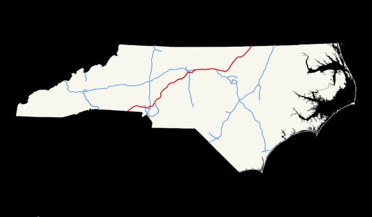
In the U.S. state of North Carolina, Interstate 85 (I-85) scales the state for 234.6 miles (377.6 km) from the South Carolina border to the Virginia border. As the second-longest interstate in the state (behind Interstate 40), it provides an important link between the cities of Atlanta, Greenville, Charlotte, Greensboro, Richmond, Virginia and Washington, D.C..
Contents
Route description
I-85 enters the state from Cherokee County, South Carolina near Grover in Cleveland County, which is part of the Charlotte metropolitan area. After only a few miles, the highway enters Gaston County. Near Kings Mountain, I-85 turns from a northeast trajectory to an eastward one and goes through Gastonia, where it widens from four to six lanes. It stays at six lanes until it reaches Belmont, where the highway widens again to eight lanes.
The highway crosses the Catawba River just before entering Charlotte. It passes north of Charlotte-Douglas International Airport and goes by a number of retail centers before turning northeastward again just west of Uptown Charlotte. The highway bypasses the downtown area, but several exits do provide access to the area. A partial wrong-way interchange exists at the exit with Interstate 77 north of Uptown.
The highway actually lies within the city limits of Charlotte for most of its route through Mecklenburg County. As a result, none of the exit signs list "Charlotte" as a destination for the intersecting routes. This can be confusing to motorists not familiar with the region, who often don't realize that they are actually within the city limits of Charlotte when searching for an exit that will take them to Bank of America Stadium, Time Warner Cable Arena, the NASCAR Hall of Fame, or other destinations in Uptown. The route through Charlotte traverses a heavily commercialized section in the northern portion of the city that is more suburban than urban in character, with light industry such as truck terminals, warehouses, small manufacturing facilities, and small office parks lining the highway. It also passes by the University City area and the University of North Carolina at Charlotte.
After Charlotte, I-85 continues northeastward into Cabarrus County, passing through the cities of Concord and Kannapolis. It drops from eight to four lanes between exit 55 (near Concord and Huntersville) and exit 68 near the Rowan County town of China Grove, at which point it increases to eight lanes again.
Between Exits 96 and 102, the northbound and southbound lanes switch places. The southbound lane crosses over the northbound lane just before the northbound lane passes over a small bridge over Hamby Creek. East of the northbound overpass and southbound underpass with Squire Bowers Road, a pair of rest areas which contain the North Carolina Vietnam Veterans Memorial Park are entered from the right, but are still in the median. Only after the underpasses beneath Johnstown Road does the northbound lane run over the southbound one returning to its proper location.
Approximately 70 miles (110 km) northeast of the Charlotte area is the Triad area, anchored by the cities of Winston-Salem, Greensboro and High Point. I-85 bypasses High Point and also largely bypasses Greensboro. Up until February 2004, I-85 went through the heart of Greensboro and joined Interstate 40 near downtown. Today, I-85 is routed along the Greensboro Urban Loop and meets I-40 east of downtown. Its former route is now known as Business 85.
Interstates 85 and 40 remain joined as they continue eastward to the Triangle region, anchored by the cities of Chapel Hill, Durham and Raleigh. West of Durham near Hillsborough, the two highways split, with I-40 heading southeast through Chapel Hill, Durham and Raleigh while I-85 continues eastward through Durham, then northeastward as it exits the city. In between Greensboro and Durham, 85/40 is 8 lanes wide even through the more suburban stretches. Once 85 hits Durham is widens to 10 lanes. It takes on a more suburban character once it leaves Durham, bypassing Oxford and Henderson before crossing into Mecklenburg County, Virginia.
Dedicated and memorial names
I-85 in North Carolina feature a few dedicated or memorialized stretches of freeway.
History
Parts of Interstate 85 were already constructed before federal aid was available in the 1950s, as the state had been constructing sections of the Interstate Highway System since 1949. The Lexington Bypass north of Lexington - which at the time was signed U.S. 29 and U.S. 70 - is now a part of Business I-85. This was part of an 80-mile expressway completed in 1955 between Salisbury and Hillsboro.
One planned road was the Salisbury bypass, 15 miles (24 km) long with a $1 million 880-foot (270 m) twin-span bridge over the Yadkin River. Construction on the bridge started in 1955 (this date is shown on a plaque, and most sources have used the date), but the lanes were not as wide as federal standards required, and the road had a sharp curve north of the bridge. Both of these characteristics saved money.
The Federal-Aid Highway Act of 1956 provided for 90 percent federal funding of highways that would become part of the Interstate Highway System, and the N.C. Highway Commission used the funds to build the rest of the highway, which opened as I-85 in 1958. The bridge, finished a year earlier, was "grandfathered" despite not meeting standards. Also designated as I-85 was the bypass around Charlotte.
Another section of I-85 opened to traffic on September 9, 1958 when an 11.3-mile (18.2 km) stretch in Mecklenburg County was opened.
The year 1960 saw several sections of the highway open to traffic:
By 1965, I-85 from the South Carolina border to Charlotte was complete, while it took until 1970 for the section between Charlotte and Durham to be completed. However, the "Temporary 85" designation would remain on the segment between Lexington and Greensboro until 1984 because there were too many access roads. That year, a new six-lane section opened, resulting in the "Temporary 85" designation to be dropped.
Since its completion, many widening projects have been undertaken on I-85, particularly along the stretch of highway between Gastonia and Durham. By 1988, widening I-85 to six lanes from Greensboro to Burlington was being considered. The plan was later changed to eight lanes. The $175 million project began in 1989. With the opening of a 2.3-mile (3.7 km) section in Alamance County on November 23, 1994, 21 miles (34 km) of I-85/I-40 were eight lanes. An additional 14 miles (23 km) were to be ready by 1996, giving the interstate eight lanes all the way to where I-40 turned southward at Hillsborough.
In addition, Interstate 85 was relocated in 2004, south of Greensboro, forming part of the Greensboro Urban Loop, allowing through traffic to bypass that city's downtown area. Between 2004 and 2008, I-85 was widened to eight lanes around Salisbury.
The I-85 Corridor Improvement Project, located in Rowan County and Davidson County, was a two-phase project to replace the narrow bridge over the Yadkin River and widen the freeway from four to eight lanes. In the first phase, all traffic from the old bridge moved to a new $201 million bridge in August 2012. On March 9, 2013, all eight lanes of the I-85 bridge opened to the public. The project finished eight months ahead of schedule and $44 million under budget.
From May 2010 through April 2014, I-85 was widened from four to eight lanes between exit 49 (near Charlotte Motor Speedway and Concord Mills Mall) and Exit 55.
Future
In April 2014, the N.C. Department of Transportation announced plans to add four new general purpose lanes(two in each direction), from north of N.C. 73 (Exit 55) to north of Lane Street (Exit 63) near the Cabarrus-Rowan county border. Work could begin in less than a year. Construction is scheduled to be completed by December 2017. Interchange improvements will be made to US 29/601, railroad improvements to Winecoff School Rd., realignment of Kannapolis Hwy (South Main St) from Stewart St., to Mall Drive and Carolinas HealthCare System NorthEast, The bridge on South Ridge Avenue over I-85 is scheduled to be removed, Dale Earnhardt Blvd, Lane Street, and US-29/601/I-85 Connector in Rowan County, When finished, that will leave I-85 in North Carolina with at least six lanes of highway between Exits 10 (US 29 north / US 74 – Kings Mountain, Shelby) and 164 (I-40 in Hillsborough), except for approximately five miles from Exit 63 to Exit 68 (US 29 / NC 152 – China Grove, Rockwell).
Another construction project that is part of the I-485 Charlotte Outer Loop, located in Mecklenburg County, will reconstruct the I-485 interchange (exit 48) to a fully directional interchange and widen the freeway from 6-lanes to 8-lanes from I-485 to Bruton Smith Boulevard/Concord Mills Boulevard. Currently, the entire project is expected to be completed in 2015 and at budget.