
Existed: 1957 – present Length 212.9 km | Constructed 1957 | |
 | ||
Counties | ||
Interstate 4 complete span in florida time lapse
Interstate 4 (I-4) is a 132.298-mile-long (212.913 km) Interstate Highway in the U.S. state of Florida, along a southwest–northeast axis from I-275 in Tampa to I-95 at Daytona Beach. The entirety of I-4 overlaps nearly the entirety of State Road 400 (SR 400), which extends as a contiguous, signed 4.216-mile (6.785 km) surface street in Daytona Beach from I-95 to US Highway 1 (US 1, also SR 5). I-4 has no auxiliary Interstate Highway spurs or loops; however, it intersects several tolled expressways—designated as state roads—that serve as spur and partial loop routes in the Orlando metropolitan area, which (unlike most major U.S. cities) lacks any auxiliary interstate highways.
Contents
- Interstate 4 complete span in florida time lapse
- Map of I 4 Florida USA
- Route description
- Services
- History
- Tampa area
- Orlando area
- 2008 pileup
- I 4 Ultimate
- Additional express lanes and Tampa Bay Express TBX
- Other projects
- State Road 400
- Major intersections
- In politics
- References
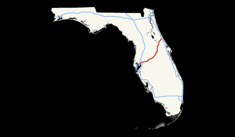
Map of I-4, Florida, USA
The first segment of I-4 opened to traffic in 1959 and the highway was largely completed in 1967. I-4's original western terminus was in St. Petersburg, but in 1971 the highway segment from St. Petersburg to its present terminus at I-275 was redesignated as part of I-75 before being redesignated again as I-275. The median of I-4 between Tampa and Orlando was the planned route of a high-speed rail line between these cities, which was cancelled in 2011. The "I-4 corridor" is a strategic region in politics, due to the large number of undecided voters in a large swing state.
Route description
I-4 maintains a diagonal, northeast–southwest route for much of its length, although it is signed east–west.
The 132-mile-long (212 km) highway's western terminus is with an interchange with Interstate 275—known as "Malfunction Junction"— near downtown Tampa and is the starting point for mile markers and exit numbers (which are mileage-based). Just east of Malfunction Junction, I-4 passes along the north side of Tampa's Ybor City district, where a mile-long connector links to the Lee Roy Selmon Expressway (SR 618) and Port Tampa Bay. I-4 continues east past the Florida State Fairgrounds towards a turbine interchange (uncommon in the U.S.) with Interstate 75.
After passing near the eastern suburbs of Hillsborough County—including Brandon and Plant City—it enters Polk County, where I-4 crosses along the north side of Lakeland. The Polk Parkway (SR 570) forms a semi-loop through Lakeland's southern suburbs and returns to I-4 at the Florida Polytechnic University campus, near Polk City; it does not serve as a bypass route for I-4 traffic. Just after the western junction with the Polk Parkway, I-4 turns from an eastward to a northeastward heading. Between SR 33 (at exit 38) and US 27, I-4 passes through the fog-prone Green Swamp, although the landscape beside the highway is mostly forest as opposed to water-logged swampland. Ten variable-message signs and dozens of cameras & vehicle detection systems monitor this stretch of mostly-rural highway as a result of several large, deadly pile-ups caused by dense fog.
At mile 57, I-4 enters Osceola County and soon thereafter intersects the Orlando area's beltways: the incomplete Western Expressway (SR 429) on the western side and the Central Florida GreeneWay (SR 417) which rounds the eastern side before returning to I-4 in Sanford. Additionally, an exit to World Drive (signed as just "Disney World") runs north as a limited-access highway into the Walt Disney World Resort and an electric pylon in the shape of Mickey Mouse can be seen on the southwest corner of the intersection. The single GreeneWay/World Drive exit (Exit 62) also marks an abrupt change from rural to suburban/urban landscape. The highway passes beside Celebration and Kissimmee on the east side and Walt Disney World Resort (not visible) on the west side.
For the next 40 miles (64 km), I-4 passes through the Orlando metropolitan area, where the highway forms the main north-south artery. It enters Orange County, passes through Walt Disney World, and by SeaWorld Orlando, & Universal Orlando—and intersects all of the area's major toll roads, including the Beachline Expressway (SR 528) and Florida's Turnpike. Orlando's main tourist strip—International Drive—runs parallel and no more than 1.5 mi (2 km) from I-4 between Kissimmee and Florida's Turnpike. Between Michigan St. and Kaley Ave. (about mile 81), I-4 changes to a north heading past downtown Orlando and its northern suburbs. A 21-mile (34 km) section of I-4 from west of Kirkman Road to east of SR 434 (miles 75-96) is currently undergoing a $2.3 billion reconstruction, expected to be completed in 2021, that replaces most bridges, changes the configuration of many intersections, and adds two express toll lanes—named 4 Express—in each direction (details in the I-4 Ultimate section).
After passing along the west side of Downtown Orlando, I-4 continues through the city's northern suburbs—including Winter Park, Maitland, Altamonte Springs, and Sanford. Around mile 91, I-4 enters Seminole County and soon thereafter shifts to a northeast heading. The Seminole Expressway (SR 417), after passing around the east side of the Orlando metropolitan area, has its northern terminus (exit 101B) at I-4 in Sanford. This intersection will also connect with the Wekiva Parkway (SR 429), currently under construction, when it is completed in 2021, at which point a full beltway (SR 429 & SR 417; concurrent with I-4 for 2 mi) around the Orlando metro area will be available.
North of Sanford, I-4 is carried by the St. Johns River Veterans Memorial Bridge over the St. Johns River at the mouth of Lake Monroe. Along the bridge, I-4 enters Volusia County and passes Deltona & DeLand. The segment north of SR 44 is being widened from four to six lanes. Completed in winter 2016-17, the entire length of I-4 will have at least 6 lanes (3+ per direction). I-4 terminates at a junction with I-95 in Daytona Beach. SR 400 continues east into Daytona Beach 4 mi to US 1.
Services
I-4 has two pairs of rest areas, one near Polk City and the other near Longwood. At each location, there are separate facilities on opposite sides of the freeway, providing services to traffic in both directions. The rest areas all provide handicapped facilities with restrooms, picnic tables, drinking water, pet exercise areas, outside night lights, telephones, vending machines and nighttime security.
FDOT closed a pair of rest areas at the Daryl Carter Parkway overpass (mile 70) near Lake Buena Vista in early 1999 and replaced them with retention ponds to serve runoff from an additional lane in each direction of I-4. Another former rest area, without any bathrooms, existed on the eastbound side near milepost 127 in Volusia County.
A pair of weigh stations including weigh in motion scales is present at mile 12 between Tampa and Plant City. They were opened in January 2009 to replace a pair just west of the SR 566 interchange at mile 19.
History
I-4 was one of the first Interstate Highways to be constructed in Florida, with the first section opening between Plant City and Lakeland in 1959. By early 1960, the Howard Frankland Bridge was opened to traffic, as well as the segment from the Hillsborough Avenue/US 301 junction in Tampa to Plant City. The stretch from Lake Monroe to Lake Helen, including the original St. Johns River Bridge also opened during that period. The segment from Tampa to Orlando was complete by 1962. By the mid 1960s, several segments were already complete, including Malfunction Junction in Tampa and parts of I-4 through Orlando. The original western terminus was set at Central Avenue (County Road 150) in St. Petersburg, though a non-Interstate extension would have continued south and west to Pasadena. Proposed I-4 was later extended southwest to the present location of exit 20, with a planned temporary end at US 19 and 13th Avenue South, and a continuation to the Sunshine Skyway was also designated as part of Interstate 4. Construction was stalled at 9th Street North (CR 803) for several years.
The entire Interstate Highway was completed by the late 1960s; however, the western terminus was truncated to Malfunction Junction in 1971 when I-75 was extended over the Frankland Bridge. Eventually, that stretch was again redesignated to become part of I-275.
In maps and atlases dating to the 1950s, 1960s, and 1970s, the Tampa–St. Petersburg section of I-4/I-275 was marked as the Tampa Expressway. The Orlando segment was marked as the Orlando Expressway. Both names have since faded from maps.
Although many post-1970 interchanges along I-4 were constructed before the recent widening projects, they were designed with I-4 expansion in mind. In other words, there is enough room available to widen I-4 to up to ten lanes without extensively modifying the interchanges. Some of these interchanges include the I-75 stack (constructed in the 1980s) and several interchanges serving the Walt Disney World Resort (constructed in the late 1980s and early 1990s).
In 2002, I-4, along with most of Florida's interstates, switched over from a sequential exit numbering system to a mileage-based exit numbering system.
A section of I-4 between Daytona Beach and Orlando called the "dead zone" is rumored to be haunted. In 2010, the ECFRPC using GIS technology performed an analysis to determine if this identified zone had an increased fatality rate related to crashes. The analysis which compared this section of I-4 to several other dangerous I-4 sections found that while the dead zone area did not have the highest accident or fatality rate, it did identify that the percentage of fatality to accident was significantly higher in this location.
The median of I-4 between Tampa and Orlando was slated to be used for the Florida High Speed Rail line between those cities. As a result of a state constitutional amendment to build a high speed rail system between its 5 largest cities passed by voters in 2000, construction projects on I-4 included a wide median to accommodate a high speed rail line. The high speed rail project was cancelled in 2004, but revived again in 2009. In 2010, the federal government awarded Florida over $2 billion—nearly the entire projected construction cost—to build the line, with work on the project to begin in 2011 and be completed by 2014.
Tampa area
The I-4/I-275 interchange (Malfunction Junction) was rebuilt from 2002 to 2007, and I-4 has been widened from four to six lanes (with eight lanes in certain segments). Eventually, I-4 will be widened again to a total of at least ten lanes (five in each direction). Studies for this project are already underway and construction should commence sometime in the 2010s. Completion of the project should be around 2020.
Eastbound I-4 shifted to its new, permanent alignment between Malfunction Junction and 50th Street on August 8, 2006. The new alignment includes a right-lane ramp exit/entry at the 22nd St/21st St Interchange (The previous left-lane configuration was causing hazardous conditions to commuters since its opening in 2005). On August 11, 2006, a fourth lane opened on eastbound I-4 between the downtown junction and 50th Street (led in by a newly opened third lane on the eastbound I-4 ramp from northbound I-275). And on August 18, the new westbound alignment, just west of 50th Street, opened. The newly opened lanes will improve flow throughout the interchange. The 50th Street overpass, however, would not be complete until late 2007. Also, the eastbound I-4 exit ramp to Columbus Drive/50th Street is situated to the left-hand side of the highway (as opposed to its former right-hand side exit). This exit shift went into effect in spring 2006 and is part of the new, permanent interstate configuration.
In Tampa, the exit to 40th Street (SR 569), exit 2, was closed and demolished in late 2005 due to the ongoing reconstruction of I-4 and to accommodate a proposed connector highway with the Lee Roy Selmon Expressway.
The interchange with what is today I-75 was constructed in the early 1980s.
Orlando area
As Orlando grew in the 1970s and 1980s, traffic became a growing concern, especially after the construction of the original interchange with the East–West Expressway in 1973, which proved to become a principal bottleneck. The term "highway hostages" was coined in the 1980s to describe people stuck in long commutes to and from Orlando on I-4.
In the early-to-mid 1990s, several interchanges near Kissimmee were constructed or upgraded to accommodate increasing traffic going to and from Walt Disney World. However, I-4's main lanes were not widened in the process. Around the same time, SR 417 was extended to I-4. Improvements to the US 192 junction were completed in 2007.
The St. Johns River Veterans Memorial Bridge, a two-span, six-lane replacement to the original four-lane bridge over the St. Johns River northeast of Orlando, was completed in 2004.
During the early 2000s, tolled express lanes were being planned in the Orlando area as a traffic congestion relief technique for rush hour commuters. The name for them was to be Xpress 400, numbered after the state road designation for I-4. The express lanes were slated to extend from Universal Orlando, east to SR 434 in Longwood, and tolls were to be collected electronically via transponders like SunPass and Orlando-Orange County Expressway Authority's E-Pass, with prices dependent on the congestion of the eight main lanes. However, the project was effectively banned by the passage of the SAFETEA-LU Federal transportation bill in 2005, introduced by U.S. Representative John Mica. The plan for tolled express lanes is now moving forward as part of the $2.3 billion I-4 Ultimate project (see "I-4 Ultimate" section below).
Interim improvements to the interchange at SR 408 were completed at the end of 2008. The eastbound exit to Robinson Street (SR 526) permanently closed on April 25, 2006, to make way for construction of the new eastbound onramp from SR 408. The westbound offramp to Gore Street was permanently closed in the same project on November 2, 2008.
The new overpass from I-4 west to John Young Parkway (County Road 423, CR 423) opened the morning of April 27, 2006.
2008 pileup
On January 9, 2008, 70 vehicles were involved in a large pileup on I-4 near Polk City. The pileup was caused by an unexpected thick morning fog that was mixed with a scheduled—and approved—environmental burn by the Florida Wildlife Commission. The fog drifted across I-4, mixing with the smoke, reducing visibility to near-zero conditions. Four people were killed, and 38 were injured. The section of I-4 did not re-open until the next day, January 10.
I-4 Ultimate
A $2.3 billion (in year-of-expenditure dollars) project—dubbed I-4 Ultimate—will reconstruct 21-mile (34 km) of I-4 through Orlando from SR 435 (exit 75) east to SR 434 (exit 94). The most noticeable improvement will be the addition of four variable-toll express lanes along this section, to be called 4 Express. The express lanes will be variably tolled in an attempt to maintain an average speed of 50 miles per hour (80 km/h). Additionally, the general-use lanes will be rebuilt, 15 major interchanges will be reconfigured, 53 new bridges will be added, and 75 bridges will be replaced. Two pedestrian bridges will be built over the highway near Kirkman Road and Maitland Boulevard. The project will also reduce the curve radius and improve line-of-sight along the notorious Fairbanks Curve south of Fairbanks Avenue, which is the most accident-prone section of I-4.
FDOT proposed adding barrier-separated HOV lanes to I-4 through the Orlando metro area in the 1990s, possibly funded by tolls, but proposals for express lanes (including reversible toll lanes and HOT lanes) were blocked by politics for the next 15 years. In 2012, a ban on tolls on I-4 inserted in federal legislation, which had been in place for seven years, ended and FDOT began soliciting private enterprises to build and help finance the project in a public-private partnership. In February 2013, the state legislature and governor gave approval for FDOT to proceed with the public-private partnership on this section of I-4 in February 2013 and the following year, FDOT selected I-4 Mobility Partners to design, construct, finance, maintain and operate the project for 40 years. FDOT and I-4 Mobility Partners reached commercial and financial close and a public-private partnership concession agreement was executed in September 2014. The final design phase began in October 2014. On February 1, 2015, FDOT turned the project over to I-4 Mobility Partners and on February 18, transportation officials and the governor held a groundbreaking ceremony for the project in Maitland. I-4 Mobility Partners has a March 2021 deadline to complete the project.
Additional express lanes and Tampa Bay Express (TBX)
Extensions of the 4 Express toll lanes both southwest and northeast of the I-4 Ultimate project are being considered. In 2013, FDOT initiated a reevaluation study to reevaluate previous feasibility studies, made between 1998 and 2005, in which the addition of HOV or express toll lanes were considered. The extensions cover approximately 40 miles (64 km) of I-4 through the Orlando metro area. Southwest of the I-4 Ultimate, the study is examining an extension through Osceola County to US 27 in Polk County. Northeast of the I-4 Ultimate, the study is examining an extension through Seminole County to SR 472 in Volusia County. The reevaluation is expected to be complete in July 2015.
Express toll lanes are also being considered for I-4 in the Tampa Bay area. In January 2015, FDOT unveiled its master plan for a system of express toll lanes—dubbed Tampa Bay Express (TBX)—on I-4, I-75, and I-275 and began public meetings for community input. On I-4, these lanes would extend approximately 26 miles (42 km) from I-275 to west of the Polk Parkway (SR 570). At the junction with I-275, the initial concept alignment calls for a direct connection between the express toll lanes of both highways. Express bus lanes for regional, long distance bus service were studied for inclusion in the plan. The I-4 corridor was considered in the bus lane study, but the resultant proposal only included installation on I-275 and I-75
Other projects
Connections with two new expressways are planned. The Wekiva Parkway—a 25-mile (40 km) segment of SR 429—will connect to SR 417 at the I-4 interchange in Sanford. When completed in 2021, it will complete the beltway around Orlando, although the southern ends of SR 429 and SR 417 do not connect and are separated by a 3.4-mile (5.5 km) drive along I-4. The Central Polk Parkway is a planned tolled expressway in eastern Polk County that will connect I-4 near Davenport with the Polk Parkway near Bartow; it is currently in the design phase, but funding for right-of-way acquisition of the initial segments is not planned until fiscal year 2019/20. Additionally, FDOT is conducting a feasibility study for a 5–11.5-mile (8.0–18.5 km) connection between I-4 and the Poinciana Parkway—a short, tolled expressway under construction between US 17/US 92 and the community of Poinciana.
The final four-lane segment of I-4, from SR 44 to I-95, was widened to six lanes. Completed in winter 2016-17, the whole highway is at least six lanes wide.
In 2014, the Florida Department of Transportation began a study of the feasibility of extending the SunRail commuter train line to Daytona Beach, primarily focusing on the use of the I-4 median. The ongoing widening project from SR 44 to I-95 maintains a median wide enough to accommodate a future rail line.
State Road 400
State Road 400 (SR 400), unsigned while concurrent with I-4, becomes signed east of I-95. The road extends for three miles (4.8 km) from the northeast terminus of I-4, on the south side of Daytona International Speedway and Daytona Beach International Airport, to an intersection with US 1 (SR 5) in Daytona Beach. Named Beville Road, it runs along the boundary between the cities of Daytona Beach and South Daytona. Sections of Beville Road are classified as a "Scenic Thoroughfare" by the City of Daytona Beach.
Major intersections
The entire route is in Volusia County.
In politics
In the 2004 U.S. presidential election, the I-4 corridor, a commonly used term to refer to the counties in which Interstate 4 runs through and a site of significant population growth, was a focus of political activity within the swing state of Florida. Communities along the I-4 corridor were perceived by both major political parties as having higher proportions of undecided voters as compared to more Republican- or Democratic-leaning portions of the state. It played an equally key role in the 2008 U.S. presidential election, but whereas the corridor had voted heavily for George W. Bush in 2004, which helped Bush win the state, in 2008 it swung behind Democratic candidate Barack Obama, helping Obama win Florida. The I-4 corridor previously voted for the statewide winner from 1996 to 2012. In the most recent election, Republican Donald Trump carried the state, and won the presidency without winning the region. The Republicans carried the region three times while the Democrats carried the region four times in the past seven presidential elections. Republicans George H. W. Bush and George W. Bush won more votes than other candidates in 1992, 2000, and 2004, while Democrats Bill Clinton, Barack Obama, and Hillary Clinton captured the region's vote total in the elections of 1996, 2008, 2012, and 2016.