
Existed: 1955 – present Constructed 1955 | History: Finished in 1972 Length 48.02 km | |
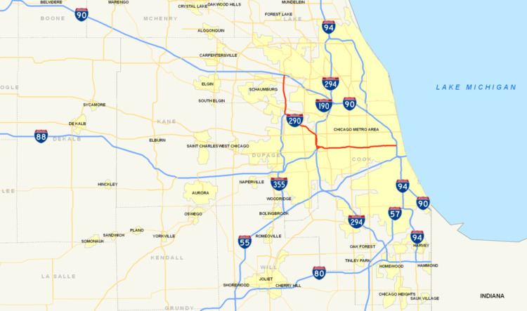 | ||
Interstate 290 (I-290) is an auxiliary Interstate Highway that runs westwards from the Chicago Loop. The portion of I-290 from I-294 to its east end is officially called the Dwight D. Eisenhower Expressway. In short form, it is known as "the Ike" or the Eisenhower. Before being designated the Eisenhower Expressway, the highway was called the Congress Expressway because of the surface street that was located approximately in its path and onto which I-290 runs at its eastern terminus in the Chicago Loop.
Contents
- Map of I 290 Illinois USA
- Jane Addams Memorial Tollway to Veterans Memorial Tollway
- Eisenhower Extension
- Tri State Tollway to Austin Boulevard
- Austin Boulevard to Chicago Loop
- History
- Post Office
- References
Map of I-290, Illinois, USA
I-290 connects I-90 (Jane Addams Memorial Tollway) in Rolling Meadows with I-90/I-94 (John F. Kennedy Expressway / Dan Ryan Expressway) near the Loop. North of I-355, the freeway is sometimes known locally as Illinois Route 53 (IL 53), or simply Route 53, since IL 53 existed before I-290. However, it now merges with I-290 at Biesterfield Road. In total, I-290 is 29.84 miles (48.02 km) long.
Jane Addams Memorial Tollway to Veterans Memorial Tollway
This section is seven miles (11 km) long and runs from Rolling Meadows to Addison. It is the portion of I-290 more locally known as "Route 53." Here, I-290 runs largely above-grade through Schaumburg, Illinois and Elk Grove Village, and at or below grade through Itasca and Addison.
The northern five miles (8.0 km) of this highway were reconstructed in 2003–04. A left shoulder and an auxiliary lane between ramps were added, as well as improved lighting. The highway is four lanes wide (not counting the auxiliary lane) north of the Elgin–O'Hare Expressway / Thorndale Avenue (mile marker 5), and five lanes wide with a wide left shoulder south to the exit to I-355.
Between mile markers 0 and 4, IL 53 overlaps this section of the Eisenhower Expressway.
Eisenhower Extension
This section is 11 miles (18 km) long and runs from Addison to Hillside. It took its name when the Eisenhower was extended northwest from Hillside. The highway runs largely at-grade or above-grade for this length. U.S. Route 20 (US 20) overlaps I-290 around Elmhurst from mile markers 12 to 13, and runs parallel to the rest of this section between mile markers 7 and 18.
This section of I-290 varies in width from two lanes at the ramp east from the I-290/I-355 split, to three lanes between I-355 and US 20, to three lanes plus two exit lanes at US 20/IL 64 (Lake Street / North Avenue) (exit 13B). After exit 13B, the highway reverts to three through traffic lanes. Exit 15 to southbound I-294 is a frequent point of congestion due to ramp traffic backing up onto the mainline highway, often as long as two miles (3.2 km). This is because the ramp is not isolated from the mainline, only one lane in width, is a low-speed ramp (marked as a 35 mph (56 km/h) ramp), and is relatively short (1⁄4 mi or 0.40 km) while carrying a high volume of truck traffic south to Indiana from North Avenue. Additionally, the sudden appearance of the exit tends to cause accidents when cars in the center lane try to aggressively turn into the right lane, particularly at the mouth of the I-294 exit. Finally, there is a dangerous high-volume weaving situation at the end of the ramp to I-294 with southbound I-294 traffic exiting to westbound I-88. As of 2006, there are no plans to overcome any of these problems with new construction.
The western three miles (4.8 km) of this section are blacktop, while east of IL 83 (exit 10) the original concrete is still in place.
Tri-State Tollway to Austin Boulevard
This section of I-290 is seven miles (11 km) long, and it runs from Hillside all the way to the western border of Chicago. This section is sometimes referred to as "The Avenues". As of 2002, it is the third-most-congested stretch of highway in the Chicago area, behind the Circle Interchange area and the intersection of the Dan Ryan Expressway and the Chicago Skyway. It is known for having a high volume of traffic on ramps through the Avenues, and high volumes of traffic on left-side ramps in Forest Park and Oak Park. I-290 runs above grade west of Mannheim Road, and at or below grade east of Mannheim Road.
Eastbound at Mannheim Road (exit 17), the highway splits into two express and one local lane; they are joined by two onramps from I-88 and form express lanes three lanes wide and local lanes to Mannheim Road two lanes wide. After Mannheim Road, the highway immediately narrows to three lanes in width, causing mile-long (1.6 km) backups. It remains three lanes to Austin Boulevard. Westbound, I-290 merely is three lanes wide to Mannheim Road, and then four lanes wide to the I-88/I-290 split. Exits at Harlem Avenue (exit 21B) and Austin Boulevard (exit 23) are Inverted single-point urban interchanges (inverted SPUIs), with left offramps and onramps. These cause backups as trucks switch lanes to exit, and a large volume of traffic enters on the left side of the highway.
In 2001–02, this section between mile markers 15 and 18 was reconstructed in the first phase of an attempt to untangle the "Hillside Strangler", adding the local lanes and extra on-ramp to I-290. The second phase, reconstruction of the highway between mile markers 18 and 23 (Mannheim Road to Austin Boulevard), is still in the preliminary engineering phase of construction as of April 2009.
Austin Boulevard to Chicago Loop
The easternmost section of I-290 is seven miles (11 km) long and runs entirely through the city of Chicago to the terminus at I-90/I-94. It runs below grade for its entire length.
This highway is four lanes wide in both directions for its entire length, and most on-ramps and off-ramps are located just two blocks apart. Therefore, an exit in one direction may be marked one street (ex. Laramie Avenue), while the same exit in the other direction may be marked another (ex. Cicero Avenue), even though the streets are only a block apart. This configuration results in most exits on this portion of road being marked as A/B exits.
Eastbound congestion is lighter here than through the "Avenues", generally limited to congestion on the tight onramps to the Kennedy and Dan Ryan Expressways (the Circle Interchange) at the eastern terminus or blind onramps at Kostner Avenue and at Homan Avenue. Westbound, congestion is heavy starting at Laramie due to the left-hand exit at Austin (which combines a "perfect storm" of a four-down-to-three lane reduction, an unfamiliar left-hand exit, and entrance and in-merging traffic of the central onramp). Most afternoons, this bottleneck can skyrocket the "Post Office to Wolf (Road)" commute time to over an hour (up from 16 mins with no traffic).
The Eisenhower Expressway runs along blacktop pavement for the length of the section, except between Kostner Avenue and Independence Boulevard, where it runs on concrete pavement.
The eastern terminus of I-290 is the Circle Interchange with I-90/I-94. After this junction, the route becomes an elevated and continues as a highway until LaSalle Street, at which point it passes under LaSalle Street Station and comes out the other side as a city street (Congress Parkway). The Congress Parkway route continues east until the street is stopped by Buckingham Fountain.
The Blue Line operates within the median of the Eisenhower from near Halsted Street to west of Cicero Avenue. After Cicero, the line leaves the median and runs on the south side of the Eisenhower for the remainder of its journey to Des Plaines Avenue, Forest Park.
History
An expressway along the alignment of the Eisenhower Expressway was foreshadowed by Daniel Burnham's plan of 1909, which described a west side boulevard. The passageway under the old Post Office was designed to preserve the right-of-way for the future road.
The expressway is named for the former President Dwight D. Eisenhower; it originally was called the Congress Expressway because It begins on Congress Parkway in Chicago. The political columnist Mike Royko joked that it is Chicago's only Republican expressway, since the others all named after Democrats (though since that observation Bishop Louis Henry Ford, a non-political figure, had an expressway named in his honor). The first segment, 2.5 miles (4.0 km) in length opened from Mannheim Road to 1st Avenue in December 1955. On December 15, an additional four miles (6.4 km) was opened, from Ashland Avenue (1600 West) to Laramie Avenue (5200 West).
During the 1960s and 1970s, the Eisenhower Expressway was extended to Lake Street and North Avenue. In 1963, the first working example of ramp metering took place on the Eisenhower Expressway, based on successful metering through New York City tunnels and data from ramp closures in Detroit, Michigan. The first implementation utilized a police officer at the top of an entrance ramp, stopping and releasing vehicles onto the highway at a predetermined rate. Another section opened in 1972, to a north–south expressway in Addison, Illinois. At the time, this expressway was a short spur from the Eisenhower Expressway, and it was referred to as Illinois Route 53, which continued north to Schaumburg. Construction on Illinois 53 had finished in 1970.
Until 1978, the Eisenhower Expressway was marked as a part of I-90. In 1978, the I-90 designation was moved onto the John F. Kennedy Expressway and the Northwest Tollway, replacing IL 194. The Eisenhower Expressway was then renumbered as I-290.
Because the segment from I-294 to IL 53 was built last, that portion of the highway is referred to as the Eisenhower Extension. The Eisenhower Expressway, extension included, is 23 miles (37 km) long. If the IL 53 portion of I-290 is added to that, the highway is actually 30 miles (48 km) long.
In 2003–04, the first five miles (8.0 km) of I-290 out of Schaumburg were rebuilt, replacing pavement that had well-exceeded its estimated 20-year lifetime. (The original pavement was built in stages from 1963 through 1970 as part of IL 53.) A fifth auxiliary lane was added between the entrance and exit ramps of exits 1, 4, and 5. The most important safety upgrade was the demolition of the raised grassy median between the westbound and eastbound lanes, and its replacement with a permanent concrete median and wide shoulders.
Post Office
Just east of the I-290–I-90/94 Junction in downtown Chicago, the Old Chicago Main Post Office is a building that stretches over Congress Parkway. If one drives eastbound on I-290 and continues past I-90/I-94, the highway ends and becomes Congress Parkway. The Post Office was a landmark that was sometimes used in referring to the end of I-290 in downtown Chicago. For example, a traffic reporter might say "...forty minutes from Mannheim to the Post Office".
This large building was used by the United States Postal Service until 1996. The building itself was built from 1921 to 1933 in the Art-Deco style, and it is 2.5 million square feet (230,000 m2) in size. The building, built several decades before the expressway that passes through it, was originally designed to accommodate a roadway—requiring only minimal work to remove walls in the base for the freeway to pass through. In spite of its unused state, the building is still known to visitors and commuters alike as the unofficial gateway into the Chicago Loop area. In late August 2009, the United States Postal Service announced an auction was to be held to sell the facility to the highest bidder. The winning bid ($40 million) was from an English real estate developer, Bill Davies.