
Existed: July 1987 – present Constructed July 1987 | Length 226.3 km | |
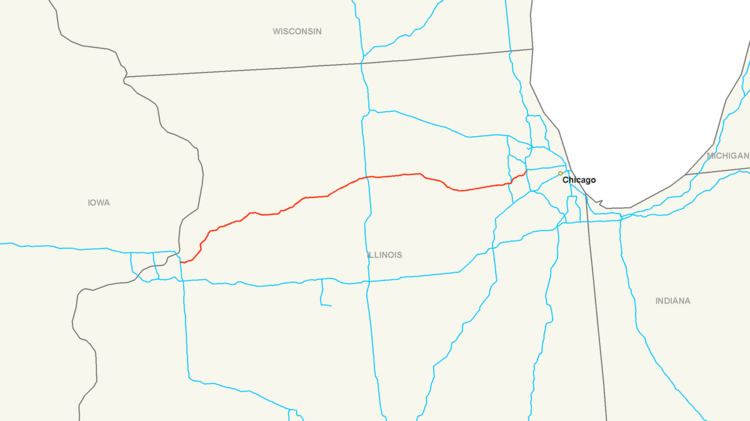 | ||
Interstate 88 (I-88) is a tolled Interstate Highway in the US state of Illinois that runs from an interchange with I-80 near Silvis and Moline to an interchange with I-290 and I-294 in Hillside, near Chicago. I-88 is 140.60 miles (226.27 km) long. This route is not contiguous to I-88 in New York. Since 2010, all of I-88 has been part of the Chicago–Kansas City Expressway. The highway also runs through the cities of Aurora, Naperville, DeKalb, and Dixon.
Contents
Map of I-88, Illinois, USA
History
Prior to its designation as an Interstate Highway, the route was known as IL 5, and before that, IL 190.
The reason for I-88's original designation and continued existence as an Interstate has to do with a technicality in the old National Maximum Speed Law (NMSL). Originally passed in 1973, NMSL was amended in 1987 to permit 65 mph (105 km/h) speed limits on rural stretches of Interstate Highways only. Even though IL 5 was fully up to Interstate standards, it still had to carry a 55 mph (90 km/h) limit because of this wording in NMSL. The Illinois Department of Transportation (IDOT) and Illinois State Toll Highway Authority (ISTHA) petitioned the American Association of State Highway and Transportation Officials (AASHTO) to re-designate IL 5 as an Interstate, and in 1987, AASHTO approved the request and assigned the Interstate 88 numbering to the highway. NMSL would be completely repealed only eight years later in 1995, but the I-88 shields remain up to this day, even though Illinois 110 shields are being posted throughout the entire Illinois I-88, since it is now part of the Chicago to Kansas City Expressway project, bannered with special "CKC" logos.
Ronald Reagan Memorial Tollway
The Ronald Reagan Memorial Tollway, originally known as the East-West Tollway, is a toll road in northern Illinois.
Opened November 21, 1958, it was initially designated as U.S. Route 30 Toll, and later Illinois Route 190. The original routing extended from the Interstate 294 interchange near Hillside to Illinois Route 47 near Sugar Grove. Illinois Route 56 was overlapped on the East-West Tollway between North Aurora and Sugar Grove in 1965.
When the East-West Tollway was extended to Dixon, Illinois in the 1970s, the Illinois 190 numbering was removed from the stretch between Aurora and Sugar Grove, making that section strictly Illinois 56. Once complete, the new routing of the combined tollway and freeway between Interstate 80 near the Quad Cities and Interstate 294 became designated as Illinois Route 5. In the late 1980s, it was renumbered as Interstate 88.
Officially, the tollway portion begins in Rock Falls, IL, starting at the intersection with U.S. Route 30 at mile marker 44, although the first toll plaza does not appear until after the Illinois Route 26 interchange in Dixon, making the section between US 30 and Illinois 26 technically a freeway. It continues as a tollway until its terminus in Hillside. West of U.S. 30 to Interstate 80, Interstate 88 is a freeway. The tollway portion is 96 miles (154 km) long.
After the death of Illinois native and former President Ronald Reagan in 2004, the Illinois State Toll Highway Authority voted to rename the toll roadway "Ronald Reagan Memorial Tollway" in his memory, as it passes near his birthplace of Tampico and grazes the south outskirts of his boyhood hometown of Dixon. The tollway portion of I-88 was previously known as the "East West Tollway" and is still displayed as such on some signs near Chicago.
There is no direct off-ramp access to U.S. Route 52, Illinois Route 23, Illinois Route 25, and Illinois Route 83 (northbound). In addition, I-88 merges with Illinois Route 56 for a short distance.
Although a federal law, 23 U.S.C. § 111, prohibits the operation of commercial rest areas constructed after January 1, 1960, on interstate highways, the DeKalb oasis was constructed at milepost 93 in 1975, prior to the route's designation as I-88 and remains in operation.
From 2005 lasting through 2012, ISTHA reconstructed and widened much of the original portion of I-88, between York Road and IL 56. Approximately $991.6 million was budgeted for I-88 over that period. Between 2005 and 2009, I-88 was reconstructed and widened to four lanes in each direction between IL 59 and York Road, with work progressing gradually from west to east. The project included a reconstruction and reconfiguration of the Naperville Road interchange. Between IL 56 and the Aurora Toll Plaza, I-88 was reconstructed and widened to three lanes, including the reconstruction of the IL 31 interchange and new bridges over the Fox River.
A $36 million interchange at Eola Road in Aurora opened on November 20, 2009, after approximately ten years of planning and less than one year of actual construction. Toll booths at this ramp accept only I-PASS, and have no provisions for accepting cash payments.