
- elevation 5,194 ft (1,583 m) | - elevation 8,380 ft (2,554 m) Length 110 km | |
 | ||
The North Fork of the Humboldt River is an approximately 70 miles (110 km) long tributary of the Humboldt River in northern Elko County, Nevada.
Contents
Map of North Fork Humboldt River, Nevada, USA
CourseEdit
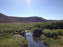
The river has its headwaters on the north slopes of McAfee Peak in the Independence Mountains of northeastern Nevada. It quickly exits the mountains and turns southward for approximately 25 miles (40 km), joining its waters with numerous other streams. Making a sharp bend to the east, it flows through a small gorge called Devil's Gap, and then combines with Beaver Creek before resuming its southward course. The river, often with no more than a trickle of water left after its long journey through the dry hills of north-central Elko County, finally flows into the main branch of the Humboldt River about 15 miles (24 km) northeast of the city of Elko.
HistoryEdit
The North Fork watershed is remote. Some mining activity in the area took place in about 1870, followed by cattle ranching, and later sheep ranching in the 1890s. Problems of overgrazing and erosion in the Independence Mountains, which form the headwaters of the North Fork, prompted the federal government to establish the Independence Forest Reserve in 1906. This reserve has since been incorporated into the Mountain City Ranger District of the Humboldt-Toiyabe National Forest.