
 | ||
Owyhee desert
The Owyhee Desert ecoregion, within the Deserts and xeric shrublands Biome, is in the Northwestern United States. The Owyhee Uplands Byway passes through the desert.
Contents
Map of Owyhee Desert, Nevada, USA
Geography
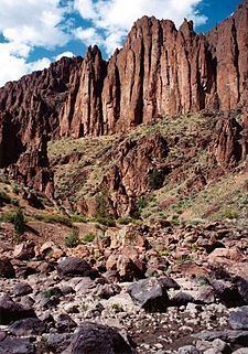
An arid region of canyons, volcanic rock, sagebrush and grass makes up the ~9,375 sq mi (24,280 km2) Owyhee Desert.
The desert is in northern Nevada, southwestern Idaho and southeastern Oregon. It is located on the south edge of the Columbia Plateau southwest of Boise, Idaho, stretching east from the Santa Rosa Range. It has a mean elevation of approximately 5,300 ft (1,600 m). The Owyhee Desert is primarily drained by the tributaries of the Bruneau River and Owyhee Rivers, which then flow into the Snake River.
Management
Most of the land in the desert is owned by the federal government and managed by the Bureau of Land Management. It is largely used as ranch land.
In 1999, the Desert Group submitted an alternative for Owyhee resource management.