
Country United States State | Population 117,240 (2013) Area 78.25 sq mi Mayor Eileen Weir | |
 | ||
Colleges and Universities Metropolitan Community College-Blue River Points of interest Harry S Truman Presidential Library and Museum, Harry S Truman National Historic Site, Community of Christ, Leilas Hair Museum, Nelson-Atkins Museum of Art | ||
Unemployment rate 7.4% (Feb 2015) | ||
Map of Independence, Missouri
Independence is the fifth-largest city in the state of Missouri. It lies within Jackson County, of which it is the county seat. Independence is a satellite city of Kansas City, Missouri, and is part of the Kansas City metropolitan area. In 2010, it had a total population of 116,830.
Contents
- Map of Independence Missouri
- Best trip to bass pro independence missouri
- The underground storage area in independence mo
- History
- Geography
- 2010 census
- 2000 census
- Top employers
- Schools
- Colleges and universities
- Churches
- Libraries
- Newspapers
- Television
- Culture
- Museums
- Sports
- Sister city
- Highways and roads
- Hospital
- Transportation
- Utilities
- Notable people
- References
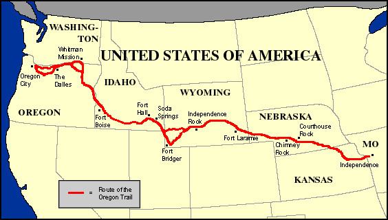
Independence is known as the "Queen City of the Trails" because it was a point of departure for the California, Oregon, and Santa Fe Trails. Independence was also the hometown of U.S. President Harry S. Truman; the Truman Presidential Library and Museum is located in the city, and Truman and First Lady Bess Truman are buried here. The city is also sacred to many Latter Day Saints, with Joseph Smith's 1831 Temple Lot being located here, as well as the headquarters of several Latter Day Saint factions.
Best trip to bass pro independence missouri
The underground storage area in independence mo
History
Independence was originally inhabited by Missouri and Osage Indians, followed by the Spanish and a brief French tenure. It became part of the United States with the Louisiana Purchase of 1803. Lewis and Clark recorded in their journals that they stopped in 1804 to pick plums, raspberries, and wild apples at a site that would later form part of the city.
Named after the Declaration of Independence, Independence was founded on March 29, 1827, and quickly became an important frontier town. Independence was the farthest point westward on the Missouri River where steamboats or other cargo vessels could travel, due to the convergence of the Kansas River with the Missouri River approximately six miles west of town, near the current Kansas-Missouri border. Independence immediately became a jumping-off point for the emerging fur trade, accommodating merchants and adventurers beginning the long trek westward on the Santa Fe Trail.
In 1831, members of the Latter Day Saint movement began moving to the Jackson County, Missouri area. Shortly thereafter, founder Joseph Smith declared a spot west of the Courthouse Square to be the place for his prophesied temple of the New Jerusalem, in expectation of the Second Coming of Christ. Tension grew with local Missourians until the Latter Day Saints were driven from the area in 1833, the beginning of a conflict which culminated in the 1838 Mormon War. Several branches of this movement gradually returned to the city beginning in 1867, with many making their headquarters there. These include the Community of Christ (formerly the Reorganized Church of Jesus Christ of Latter Day Saints), the Church of Christ (Temple Lot), the Church of Jesus Christ (Cutlerite) and the Restoration Branches.
Independence saw great prosperity from the late 1830s through the mid-1840s, while the business of outfitting pioneers boomed. Between 1848 and 1868, it was a hub of the California Trail. On March 8, 1849, the Missouri General Assembly granted a home-rule charter to the town and on July 18, 1849, William McCoy was elected as its first mayor. In the mid-19th century an Act of the United States Congress defined Independence as the start of the Oregon Trail.
Independence saw two important battles during the Civil War: the first on August 11, 1862, when Confederate soldiers took control of the town, and the second in October 1864, which also resulted in a Southern victory. The war took its toll on Independence and the town was never able to regain its previous prosperity, although a flurry of building activity took place soon after the war. The rise of nearby Kansas City also contributed to the town's relegation to a place of secondary prominence in Jackson County, though Independence has retained its position as county seat to the present day.
United States President Harry S. Truman grew up in Independence, and in 1922 was elected judge of the county Court of Jackson County, Missouri (an administrative, not judicial, post). Although he was defeated for reelection in 1924, he won back the office in 1926 and was reelected in 1930. Truman performed his duties diligently, and won personal acclaim for several popular public works projects, including an extensive series of fine roads for the growing use of automobiles, the building of a new County Court building in Independence, and a series of 12 Madonna of the Trail monuments to pioneer women dedicated across the country in 1928 and 1929. He would later return to the city after two terms as President. His wife, First Lady Bess Truman, was born and raised in Independence, and both are buried there. The Harry S. Truman National Historic Site (Truman's home) and the Harry S. Truman Presidential Library and Museum are both located in Independence, as is one of Truman's boyhood residences.
Geography
Independence is located at 39°4′47″N 94°24′24″W (39.079805, −94.406551). It lies on the south bank of the Missouri River, near the western edge of the state. According to the United States Census Bureau, the city has a total area of 78.25 square miles (202.67 km2), of which, 77.57 square miles (200.91 km2) is land and 0.68 square miles (1.76 km2) is water.
2010 census
As of the census of 2010, there were 116,830 people, 48,742 households, and 30,165 families residing in the city. The population density was 1,506.1 inhabitants per square mile (581.5/km2). There were 53,834 housing units at an average density of 694.0 per square mile (268.0/km2). The racial makeup of the city was 85.7% White, 5.6% African American, 0.6% Native American, 1.0% Asian, 0.7% Pacific Islander alone (1.0% Pacific Islander alone or in combination with one or more other races), 3.2% from other races, and 3.2% from two or more races. Hispanic or Latino of any race were 7.7% of the population. Non-Hispanic Whites were 82.2% of the population, down from 98.4% in 1970.
There were 48,742 households of which 29.3% had children under the age of 18 living with them, 42.5% were married couples living together, 13.9% had a female householder with no husband present, 5.4% had a male householder with no wife present, and 38.1% were non-families. 31.7% of all households were made up of individuals and 11.5% had someone living alone who was 65 years of age or older. The average household size was 2.37 and the average family size was 2.97.
The median age in the city was 39.4 years. 23% of residents were under the age of 18; 8.6% were between the ages of 18 and 24; 24.9% were from 25 to 44; 27.4% were from 45 to 64; and 16.1% were 65 years of age or older. The gender makeup of the city was 48.0% male and 52.0% female.
2000 census
As of the census of 2000, there were 113,288 people, 47,390 households, and 30,566 families residing in the city. The population density was 1,446.3 people per square mile (558.4/km²). There were 50,213 housing units at an average density of 641.1 per square mile (247.5/km²). Independence has a population of 111,806 in 1980 and 112,301 in 1990. The racial makeup of the city was 91.87% White, 2.59% African American, 0.70% Asian, 0.64% Native American, 0.46% Pacific Islander, 1.43% from other races, and 2.31% from two or more races. Hispanic or Latino of any race were 3.69% of the population.
There were 47,390 households out of which 28.1% had children under the age of 18 living with them, 47.9% were married couples living together, 12.3% had a female householder with no husband present, and 35.5% were non-families. 30.1% of all households were made up of individuals and 11.3% had someone living alone who was 65 years of age or older. The average household size was 2.37 and the average family size was 2.93.
In the city, the population was spread out with 23.9% under the age of 18, 8.7% from 18 to 24, 28.9% from 25 to 44, 23.0% from 45 to 64, and 15.5% who were 65 years of age or older. The median age was 38 years. For every 100 females there were 91.6 males. For every 100 females age 18 and over, there were 87.3 males.
The median income for a household in the city was $38,012, and the median income for a family was $45,876. Males had a median income of $34,138 versus $25,948 for females. The per capita income for the city was $19,384. About 6.4% of families and 8.6% of the population were below the poverty line, including 11.8% of those under age 18 and 6.7% of those age 65 or over.
Top employers
According to the town's 2016 Comprehensive Annual Financial Report, the top employers in the city are:
Schools
Four school districts have areas within the city: Independence, Blue Springs, Fort Osage Schools, and Raytown. Three public high schools are located within the city limits: Truman High School, Van Horn High School, and William Chrisman High School; and two private high schools, Center Place Restoration School and Family Christian Academy, are also. Fort Osage High School is adjacent to but not inside the city limits.
Prior to Fall 2008, parts of western Independence in the Van Horn feeder pattern resided in the Kansas City, Missouri School District, but all of these students are now part of the Independence school district.
Colleges and universities
Churches
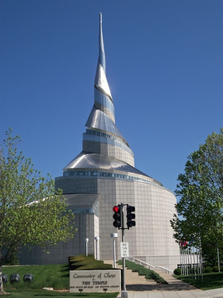
Independence played an important role in the early history of the Latter Day Saint movement, and is home to the headquarters of several separatist denominations of the Latter Day Saint movement, most notably the Community of Christ (formerly the Reorganized Church of Jesus Christ of Latter Day Saints), whose Temple is located there. Other Latter Day Saint denominations headquartered in the city include the Church of Christ (Temple Lot) and the Church of Jesus Christ (Cutlerite), among others. A number of Restoration Branches are also located in and around Independence, and The Church of Jesus Christ of Latter-day Saints maintains a visitor's center in the town.
The Community of Christ has built a temple in Independence, and also maintains a large auditorium and other buildings nearby. The Church of Jesus Christ of Latter-day Saints operates a sizable visitors' center adjacent to the Community of Christ Temple, and across the street from the original Temple Lot designated by Joseph Smith in 1830. The Lot itself is occupied by a small white-frame church building that serves as the headquarters and local meeting house for the Church of Christ (Temple Lot).
There are five Catholic churches and several Episcopal churches in Independence.
One of the oldest churches in Independence is the First Presbyterian Church, founded in 1826. It was here in 1890 that Harry Truman saw Elizabeth (Bess) Wallace. Truman eventually married her after his return from World War I in 1919.
Libraries
Newspapers
Television
Culture
Santa-Cali-Gon Days is an annual Labor Day festival held in Independence intermittently since 1940 and continuously since 1973, celebrating the city's heritage as a starting point of three major frontier trails: the Santa Fe, California and Oregon. Another popular annual festival is the Vaile Strawberry Festival, which is held on the first Saturday of June at the Vaile Mansion, 1500 N. Liberty, five blocks north of the historic Square. The Independence Heritage Festival is a celebration of the diverse culture that exist in Independence. The Independence town square features numerous family-owned shops surrounding the old main courthouse, which was modeled after Philadelphia's Independence Hall. This courthouse houses Harry S. Truman's former courtroom and office.
Museums
Sports
Blue River Community College features a soccer program with a men's team and women's team. The Trailblazers (men) went all the way to the NJCAA Region 16 semifinals before concluding their season. The Lady Trailblazers (women) finished as runners up in the region. The Independence Events Center is home of the Missouri Mavericks, a Central Hockey League mid-level professional hockey team. Independence Events Center also the home of Missouri Comets of the Major Arena Soccer League the top level of professional indoor soccer. Crysler Stadium is the home of the collegiate summer baseball Independence Veterans of the Mid-Plains League.
Local recreational sports teams include:
YMCA and Parks and Recreation have programs for various sports for all people.
Sister city
Independence has the following Sister city:
Highways and roads
Hospital
Transportation
Utilities
Independence Power & Light (IPL) is a local electric power plant owned and operated by the city. It was established in 1901 and has undergone many changes and upgrades. One change was moving from the old Dodgion Street plant (where the Roger T. Sermon Center stands now) to the Blue Valley Plant near Truman Rd. and MO-78/Lake City-Buckner Rd. IPL also draws power from other sources: the Missouri City Power Plant, and the Kansas City Power and Light Company (KCP&L), through several 69 and 161 kilovolt transmission interconnections. IPL has an "Out of Sight" power line burial program. After signing an agreement with TradeWind Energy in July, 2008, IPL will begin purchasing annually 15 megawatts of renewable energy from the Smoky Hills Wind Farm (a wind turbine facility) in Kansas.