
Country United States Elevation 21 ft (6.4 m) Population 2,081 (2013) Mayor A.D. (Zander) Guy, Jr | Incorporated (town) 1949 Time zone EST (UTC-5) Area code 910 Local time Saturday 3:19 AM | |
 | ||
Weather 15°C, Wind NW at 10 km/h, 65% Humidity | ||
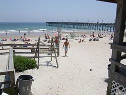
September surfing in surf city north carolina usa 2006
Surf City is a town in Pender and Onslow counties in the U.S. state of North Carolina. The population was 1,853 at the 2010 census. It is located on Topsail Island.
Contents
- September surfing in surf city north carolina usa 2006
- Map of Surf City NC USA
- Geography
- Demographics
- Piers from south to north
- References
Map of Surf City, NC, USA
The Pender County portion of Surf City is part of the Wilmington Metropolitan Statistical Area, while the Onslow County portion is part of the Jacksonville Metropolitan Statistical Area.
Geography
Surf City is located at 34°25′41″N 77°32′36″W (34.428137, -77.543198).
According to the United States Census Bureau, Surf City has a total area of 5.3 square miles (13.7 km²).4.2 square miles (10.9 km²) of it is land and 1.1 square miles (2.8 km²) of it (20.45%) is water.
Recent annexations have extended the Town Limits on the mainland west of Highway 17.
Demographics
As of the census of 2000 there were 1,393 people, 689 households, and 403 families residing in the town. The population density was 331.6 people per square mile (128.1/km²). There were 2,578 housing units at an average density of 613.7 per square mile (237.0/km²). The racial makeup of the town was 97.77% White, 0.43% African American, 0.07% Native American, 0.72% Asian, 0.14% Pacific Islander, 0.22% from other races, and 0.65% from two or more races. Hispanic or Latino of any race were 1.01% of the population.
There were 689 households out of which 12.6% had children under the age of 18 living with them, 51.5% were married couples living together, 4.9% had a female householder with no husband present, and 41.4% were non-families. 32.4% of all households were made up of individuals and 7.7% had someone living alone who was 65 years of age or older. The average household size was 2.02 and the average family size was 2.51.
In the town, the population was spread out with 12.6% under the age of 18, 6.2% from 18 to 24, 25.4% from 25 to 44, 39.6% from 45 to 64, and 16.3% who were 65 years of age or older. The median age was 48 years. For every 100 females there were 102.2 males. For every 100 females age 18 and over, there were 104.7 males.
The median income for a household in the town was $40,521, and the median income for a family was $48,854. Males had a median income of $36,600 versus $30,000 for females. The per capita income for the town was $25,242. About 9.9% of families and 15.4% of the population were below the poverty line, including 43.3% of those under age 18 and 3.9% of those age 65 or over.