
Formed August 12, 1950 Affected area Hawaii | Dissipated August 21, 1950 Highest winds 137 km/h Fatalities 1 | |
 | ||
Lowest pressure 982 mbar (hPa); 29 inHg Date 12 August 1950 – 21 August 1950 Similar Hurricane Nina, Hurricane Estelle, Hurricane Dot, 1987 Gulf Coast tropical st, Hurricane Flossie | ||
Hurricane Hiki was the wettest tropical cyclone on record in the United States. It was also considered the first official hurricane in the vicinity of the Hawaiian Islands. The fourth tropical cyclone of the 1950 Pacific hurricane season, Hiki formed as a tropical depression to the southeast of Hawaii on August 12. On the following day, the depression headed northwestward and intensified into Tropical Storm Hiki. While paralleling the Hawaiian Islands on August 16, Hiki strengthened into a hurricane. Around that time, the storm peaked with maximum sustained winds of 85 mph (140 km/h). The following day, Hiki curved southwestward on August 17. Two days later, the hurricane resumed moving northwestward and weakened to a tropical storm shortly thereafter. Around midday on August 21, Hiki weakened to a tropical depression and dissipated about six hours later.
Contents
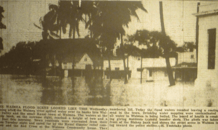
Although Hiki was a small tropical cyclone and bypassed Hawaii, heavy rainfall and strong winds were observed throughout the islands. At the Kanalohuluhulu Ranger Station on Kauai, 52 inches (1,300 mm) of precipitation was observed, which was the highest total associated with a tropical cyclone on record in the United States. The Waimea River overflowed, causing more than 200 residents to flee their homes. Many streets and several hundred acres of sugar cane fields were flooded. About $200,000 (1950 USD) in damage was reported due to flooding in the city of Waimea. In Kekaha, the powerhouse suffered severe damage. Throughout the islands, winds de-roofed several homes and downed power lines; one fatality occurred after a person came in contact with a live wire.
Meteorological history
According to ship reports during the summer, the Intertropical Convergence Zone was farther north than usual, which created favorable conditions for tropical cyclogenesis. Weather charts at the Honolulu International Airport, a tropical depression developed at 00:00 UTC on August 12, while located about 760 miles (1,220 km) southeast of the Big Island. Thereafter, the storm gradually intensified, becoming a tropical storm at 06:00 UTC on August 13. It was named Hiki, which is Hawaiian for Able. While situated east of Hilo, Hawaii, the system was described as an "immature storm", and had a very small diameter. Shortly thereafter, a reconnaissance aircraft flew into Hiki and estimated that sustained wind speeds between 50 and 60 mph (80 and 100 km/h). Further intensification continued and the system strengthened into a hurricane on August 16. Upon reaching hurricane intensity on August 16, Hiki simultaneously attained its maximum sustained wind speed of 85 mph (140 km/h). Despite this, the storm had remained small, with gale force winds extending less than 150 mi (240 km) from the center. Hiki remained between 100 and 200 mi (160 and 320 km) offshore while paralleling several Hawaiian Islands, including Hawaii, Maui, Molokai, Oahu, and Kauai.
As a high pressure ridge intensified, the northwestward movement of Hiki was blocked, causing the storm to briefly turn due west on August 17. The high pressure ridge eventually influenced the hurricane to re-curve southwestward. On August 18, a reconnaissance aircraft observed sustained winds of 90 mph (150 km/h) to the south of the center; a minimum barometric pressure of 982 mbar (29.0 inHg) was also observed. After the reconnaissance aircraft flight into the storm on August 18, residents of Kauai and Oahu were alerted of a possible cyclonic loop. However, later that day, the high pressure ridge weakened, causing Hiki to turned westward and pass south of French Frigate Shoals and Midway Island. Late on August 19, Hiki weakened to a tropical storm and then resumed its course to the northwest. By August 21, Hiki further weakened to a tropical depression, and dissipated six hours later.
The hurricane was also followed by the Air Weather Service, located on Guam, who assigned the name Salome from the Pacific typhoon naming lists.
Preparations and impact
Hiki was one of the strongest tropical cyclones to approach the Hawaiian Islands in at least 45 years and officially the first hurricane in the region. As Hiki approached, a United States Coast Guard station with 14 people in French Frigate Shoals was alerted. In addition, ships in the area were also advised to take caution. Hiki caused high waves on some of the Hawaiian Islands. Hawaii remained on the southern semicircle of Hiki, and as a result, light wind damage occurred. The highest reported winds from Hiki was at the Kilauea Lighthouse on Kauai, where gusts up to 68 mph (109 km/h) were observed. The islands of Niihau and Lanai also experienced tropical storm force winds, reaching 48 and 50 mph (77 and 80 km/h), respectively. As a result, several houses throughout the Hawaiian Islands lost their roof. In addition, a farmer in Kohala on Hawaii died after coming into contact with a live wire that was blown down from high winds.
Hiki was the wettest tropical cyclone in United States history, as rainfall of over 52 in (1,300 mm) observed at the Kanalohuluhulu Ranger Station on Kauai between August 14 and August 18. The rain gauge was capable of holding 24 inches (610 mm) of the rain and was emptied on August 15. However, less than 24 hours later, the same rain gauge was overflowing. Heavy precipitation was also recorded on other locations on that island, including 13 inches (330 mm) on Mount Waialeale. Few reports exist on rainfall totals on other Hawaiian Islands, with the only other island recording rainfall was Maui, with precipitation reaching 11.9 inches (300 mm) on August 15. This was the highest 24‑hour record for that island in the month of August. On Kauai, the Waimea River experienced one of the worst flood in its history, causing more than 200 residents in Waimea Valley to evacuate. The river also rose near the mouth of its tributary, the Makaweli River, flooding the town of Waimea, causing about $200,000 in damage. The streets on the island and hundreds of acres of sugar cane were flooded. Additionally, severe damage was reported at the Kekaha Powerhouse.